Bar nearby Harold House
Coronavirus disease (COVID-19) Situation
confirmed cases
1734582
deaths
9491
Ireland
Bar nearby Harold House
Harold House
Harold's Cross, 34-35 Clanbrassil Upper Street, Dublin Irland
contacts phone
:
+353
Latitude:
53.3300036
, Longitude:
-6.2752326
read more
nearest Bar
8 m
Harold House
34 Clanbrassil Street Upper, Dublin
Bar
read more
701 m
Peadar Browns
Lower Clanbrassil Street Clanbrassil Street Lower, Dublin
Bar
read more
724 m
Kavanaghs Of New Street
35 New Street South, Dublin 8
Bar
read more
764 m
POD
80 Dame Street, Dublin 2
Bar
read more
812 m
Bar i dublin
21 Harcourt Road, Saint Kevin's, Dublin
Bar
read more
813 m
McGowan's of Harold's Cross
174 Harold's Cross Road, Harold's Cross, Dublin
Bar
read more
895 m
Devitts Pub
78 Camden Street Lower, Dublin 2
Bar
read more
920 m
Planet Murphy's
84-, Camden Street Lower Camden Street Lower, Saint Kevin's, Dublin 2
Bar
read more
922 m
Elliots
5 Camden Row, Saint Kevin's, Dublin 7
Bar
read more
924 m
The Bowery
196 Rathmines Road Lower, Rathmines, Dublin
Bar
read more
928 m
Odeon
57 Harcourt Street, Dublin 2
Bar
read more
928 m
Odeon
Old Railway Station 2, 57 Harcourt Street, Dublin 2
Bar
read more
935 m
The Camden Sports Bar
84-87 Lwr Camden street d2, Dublin
Bar
read more
940 m
Botanical Garden Bar
13-14 Liberty Lane, Dublin 8
Bar
read more
942 m
Camden Bites & Brews
9 Camden Street Lower, Saint Kevin's, Dublin
Bar
read more
950 m
Ryan's of Camden St.
Camden Street Lower, Dublin 2
Bar
read more
954 m
D Two
60 Harcourt Street, Dublin 2
Bar
read more
977 m
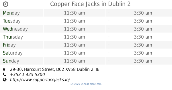
Copper Face Jacks
29-30 Harcourt Street, Dublin 2
Bar
read more
1.003 km
Bojos35
25 Harcourt Street, Dublin
Bar
read more
1.04 km
The Karma Stone Bar & Cafe
40 Wexford Street, Dublin
Bar
read more
1.083 km
Grace's
2 Rathgar Road, Dublin Southside, Rathmines
Bar
read more
1.086 km
Grace's Bar & Lounge
2 Rathgar Road, Dublin 6
Bar
read more
1.117 km
Club Chonradh na Gaeilge
6 Harcourt Street, Dublin
Bar
read more
1.154 km
The Green Hotel
1-5 Harcourt Street, Dublin 2
Bar
Lodging
Restaurant
Food
Point of interest
Establishment
read more
1.182 km
Rody Bolands
12-14 Rathmines Road Upper, Rathmines
Bar
read more
📑
all categories
Accounting
Administrative area level 1
Administrative area level 2
Airport
Amusement park
Aquarium
Art gallery
Atm
Bakery
Bank
Bar
Beauty salon
Bicycle store
Book store
Bowling alley
Bus station
Cafe
Campground
Car dealer
Car rental
Car repair
Car wash
Casino
Cemetery
Church
City hall
Clothing store
Colloquial area
Convenience store
Country
Courthouse
Dentist
Department store
Doctor
Electrician
Electronics store
Embassy
Establishment
Finance
Fire station
Florist
Food
Funeral home
Furniture store
Gas station
General contractor
Grocery or supermarket
Gym
Hair care
Hardware store
Health
Hindu Temple
Home goods store
Hospital
Insurance agency
Jewelry store
Laundry
Lawyer
Library
Light rail station
Liquor store
Local government office
Locality
Locksmith
Lodging
Meal delivery
Meal takeaway
Mosque
Movie rental
Movie theater
Moving company
Museum
Natural feature
Neighborhood
Night club
Painter
Park
Parking
Pet store
Pharmacy
Physiotherapist
Place of worship
Plumber
Point of interest
Police
Political
Post office
Premise
Real estate agency
Restaurant
Roofing contractor
Route
Rv park, camping
School
Shoe store
Shopping mall
Spa
Stadium
Storage
Store
Sublocality
Subpremise
Supermarket
Synagogue
Taxi stand
Train station
Transit station
Travel agency
University
Veterinary care
Zoo
sublocality level 1
↑