Bar nearby O'hagan's
Coronavirus disease (COVID-19) Situation
confirmed cases
1734582
deaths
9491
Ireland
Bar nearby O'hagan's
O'hagan's
Annies, Co. Louth, Irlandia
contacts phone
:
+353
Latitude:
54.0440322
, Longitude:
-6.4110368
larger map & directions
read more
nearest Bar
2.622 km
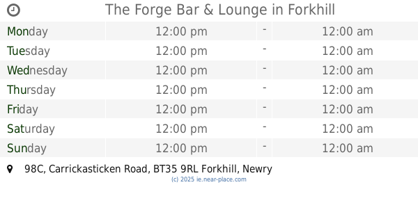
The Forge Bar & Lounge
98C Carrickasticken Road, Forkhill, Newry
Bar
read more
3.052 km
Talk of Dundalk Bar
137 Racecourse Road, Dundalk
Bar
read more
3.719 km
Harrys Bar
29 Bridge Street, Dundalk
Bar
read more
3.755 km
Mcalesters Pub
65 Bridge Street, Dundalk
Bar
read more
3.757 km
J & J McAlester
65 Bridge Street, Dundalk
Bar
read more
3.866 km
BODHRAN Bar
Bridge St Bridge Street, Townparks, Dundalk
Bar
read more
3.9 km
The Camelot Bar and Off Sales
1 Linenhall Street, Dundalk
Bar
read more
4.128 km
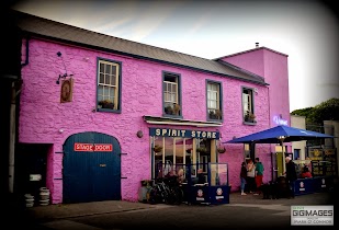
The Spirit Store
George's Quay, Dundalk
Bar
read more
4.269 km
Belles coffee boutique
6 Bachelors Walk, Dundalk
Bar
read more
4.314 km
McKeown's Bar & Lounge
16 Clanbrassil Street, Dundalk
Bar
read more
4.446 km
McGeough's Bar & Restaurant
Roden Place, Dundalk
Bar
read more
4.47 km
Greenore Railway Saloon
16 Quay Street, Dundalk
Bar
read more
4.553 km
Micheal McCourt
1 Francis Street, Dundalk
Bar
read more
4.576 km
The Bartender
12 Park St, Dundalk
Bar
read more
4.578 km
The Lounge-IMPERIAL
Park St Park Street, Townparks, Dundalk
Bar
read more
4.581 km
Parks bar
Park St Park Street, Townparks, Dundalk
Bar
read more
4.588 km
Punters Bar
Park Street, Dundalk
Bar
read more
4.671 km
Russell's Bar
Park Street, Dundalk
Bar
read more
4.704 km
Johnny Mason's Bar & Restaurant
Hagan House, The Ramparts, Dundalk
Bar
read more
4.824 km
McGuinness
27 Anne Street, Dundalk
Bar
read more
4.843 km
The Jockeys Bar
79 Anne Street, Dundalk
Bar
read more
4.863 km
The Wee House
20 Anne Street, Dundalk
Bar
read more
4.895 km
Kennedy's Bar
Dundalk
Bar
read more
4.979 km
Windsor Bar and Restaurant
Dublin Street, Dundalk
Bar
read more
5.56 km
Blue Anchor
Point
Bar
read more
📑
all categories
Accounting
Administrative area level 1
Administrative area level 2
Airport
Amusement park
Aquarium
Art gallery
Atm
Bakery
Bank
Bar
Beauty salon
Bicycle store
Book store
Bowling alley
Bus station
Cafe
Campground
Car dealer
Car rental
Car repair
Car wash
Casino
Cemetery
Church
City hall
Clothing store
Colloquial area
Convenience store
Country
Courthouse
Dentist
Department store
Doctor
Electrician
Electronics store
Embassy
Establishment
Finance
Fire station
Florist
Food
Funeral home
Furniture store
Gas station
General contractor
Grocery or supermarket
Gym
Hair care
Hardware store
Health
Hindu Temple
Home goods store
Hospital
Insurance agency
Jewelry store
Laundry
Lawyer
Library
Light rail station
Liquor store
Local government office
Locality
Locksmith
Lodging
Meal delivery
Meal takeaway
Mosque
Movie rental
Movie theater
Moving company
Museum
Natural feature
Neighborhood
Night club
Painter
Park
Parking
Pet store
Pharmacy
Physiotherapist
Place of worship
Plumber
Point of interest
Police
Political
Post office
Premise
Real estate agency
Restaurant
Roofing contractor
Route
Rv park, camping
School
Shoe store
Shopping mall
Spa
Stadium
Storage
Store
Sublocality
Subpremise
Supermarket
Synagogue
Taxi stand
Train station
Transit station
Travel agency
University
Veterinary care
Zoo
sublocality level 1
↑