Establishment nearby Funderland Dublin
Coronavirus disease (COVID-19) Situation
confirmed cases
1734582
deaths
9491
Ireland
Establishment nearby Funderland Dublin
Funderland Dublin
Simmonscourt Road, Dublin 4, IE Ireland
contacts phone
:
+353 1 283 8188
website:
www.funderland.com
Latitude:
53.3249155
, Longitude:
-6.2256699
larger map & directions
read more
nearest Establishment
97 m
Clayton Hotel Ballsbridge
Merrion Road, Dublin
Bar
Lodging
Restaurant
Food
Point of interest
Establishment
read more
530 m
Herbert Park Hotel
Ballsbridge, Dublin
Bar
Lodging
Restaurant
Food
Point of interest
Establishment
read more
801 m
€99 Teeth Whitening Dublin | White Smile Clinic
6 Donnybrook Road, Dublin 4
Dentist
Health
Point of interest
Establishment
read more
807 m
St. Michael’s College
Ailesbury Road, Dublin 4
School
University
Point of interest
Establishment
read more
867 m
Tesco Express
Units 5, 7 Donnybrook Court, Donnybrook
Supermarket
Convenience store
Grocery or supermarket
Store
Food
Point of interest
Establishment
read more
1.029 km
Tesco Superstore
Nutley Building, Merrion Centre, Merrion Road, Merrion
Supermarket
Convenience store
Grocery or supermarket
Store
Food
Point of interest
Establishment
read more
1.121 km
Tesco Metro
80 Sandymount Road, Sandymount
Supermarket
Convenience store
Grocery or supermarket
Store
Food
Point of interest
Establishment
read more
1.162 km
Estadio Aviva
Lansdowne Road, Dublin 4
Stadium
Point of interest
Establishment
read more
1.223 km
St Vincent's University Hospital
196 Merrion Road, Elm Park, Dublin
Hospital
Point of interest
Establishment
read more
1.253 km
ITW Dance Studio @ITWStudios
Terminus Mills, Bóthar Chluain Sceach, Ranelagh
University
Point of interest
Establishment
read more
1.287 km
O'Connor Golf Tours
127 Stillorgan Road, Stillorgan
Travel agency
Point of interest
Establishment
read more
1.415 km
Bank of Ireland
230 Merrion Road, Ballsbridge, Dublin 4
Bank
Atm
Finance
Point of interest
Establishment
read more
1.449 km
AIB Bank
52 Baggot Street Upper, Dublin
Bank
Finance
Point of interest
Establishment
read more
1.549 km
Burlington Dental Clinic
Burlington Dental Clinic, 16 Burlington Road, Ballsbridge, Dublin 4
Dentist
Health
Point of interest
Establishment
read more
1.682 km
Grand Canal Hotel
Grand Canal Street Upper, Dublin
Lodging
Point of interest
Establishment
read more
1.689 km
Tesco Express
113 - 115 Sandford Road, Ranelagh
Supermarket
Convenience store
Grocery or supermarket
Store
Food
Point of interest
Establishment
read more
1.838 km
Ringsend Post Office
Gordon House, Barrow Street, Ringsend, Dublin 4
Post office
Finance
Point of interest
Establishment
read more
1.86 km
AIB ATM Student Centre
University College Dublin, UCD Student Centre, Stillorgan Road, Belfield, Dublin
Atm
Bank
Finance
Point of interest
Establishment
read more
1.868 km
ITW at Beechwood Parish Community Centre
Beechwood Community Centre, Mountain View Road, Ranelagh
University
Point of interest
Establishment
read more
2.032 km
Network One
2 Fitzwilliam Place, Dublin
University
Point of interest
Establishment
read more
2.161 km
Il Valentino Bakery & Cafe
5 Gallery Quay, Grand Canal Harbour, Dublin 2
Bakery
Cafe
Store
Food
Point of interest
Establishment
read more
2.181 km
KC Peaches Catering & Café Pearse Street
10A, Trinity Enterprise Center, Pearse Street, Dublin
Cafe
Store
Restaurant
Food
Point of interest
Establishment
read more
2.372 km
Quintessentially
22 Ely Place, Dublin
Travel agency
Point of interest
Establishment
read more
2.444 km
American College Dublin
Merrion Square North, Dublin
University
Point of interest
Establishment
read more
2.467 km
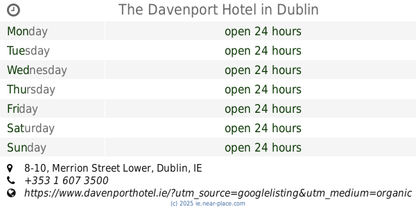
The Davenport Hotel
8-10 Merrion Street Lower, Dublin
Cafe
Bar
Lodging
Restaurant
Food
Point of interest
Establishment
read more
📑
all categories
Accounting
Administrative area level 1
Administrative area level 2
Airport
Amusement park
Aquarium
Art gallery
Atm
Bakery
Bank
Bar
Beauty salon
Bicycle store
Book store
Bowling alley
Bus station
Cafe
Campground
Car dealer
Car rental
Car repair
Car wash
Casino
Cemetery
Church
City hall
Clothing store
Colloquial area
Convenience store
Country
Courthouse
Dentist
Department store
Doctor
Electrician
Electronics store
Embassy
Establishment
Finance
Fire station
Florist
Food
Funeral home
Furniture store
Gas station
General contractor
Grocery or supermarket
Gym
Hair care
Hardware store
Health
Hindu Temple
Home goods store
Hospital
Insurance agency
Jewelry store
Laundry
Lawyer
Library
Light rail station
Liquor store
Local government office
Locality
Locksmith
Lodging
Meal delivery
Meal takeaway
Mosque
Movie rental
Movie theater
Moving company
Museum
Natural feature
Neighborhood
Night club
Painter
Park
Parking
Pet store
Pharmacy
Physiotherapist
Place of worship
Plumber
Point of interest
Police
Political
Post office
Premise
Real estate agency
Restaurant
Roofing contractor
Route
Rv park, camping
School
Shoe store
Shopping mall
Spa
Stadium
Storage
Store
Sublocality
Subpremise
Supermarket
Synagogue
Taxi stand
Train station
Transit station
Travel agency
University
Veterinary care
Zoo
sublocality level 1
↑