Park nearby Coffey's Field, Cork City Council Amenity.
Coronavirus disease (COVID-19) Situation
confirmed cases
1734582
deaths
9491
Ireland
Park nearby Coffey's Field, Cork City Council Amenity.
Coffey's Field, Cork City Council Amenity.
Sports Ground, Kinsale Road, Cork, Co. Cork, Ireland
contacts phone
:
+353
Latitude:
51.8753299
, Longitude:
-8.4932073
larger map & directions
read more
nearest Park
459 m
Neenan Park
Cork
Park
read more
613 m
Creedon's Dog Care
Unit 1 South Cork Industrial Estate Vicars Road, Pouladuff Rd, Cork
Park
read more
625 m
Clashduv Park
Dun Barra, 48 Riverview Estate, Glasheen
Park
read more
1.364 km
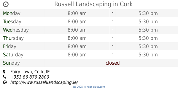
Russell Landscaping
Locmor, Fairy Lawn, The Lough, Cork
Park
read more
1.418 km
Lough Park
4 Fairy Ville Lawn, The Lough
Park
read more
1.508 km
Presentation Brothers College Sports Grounds
Cork
Park
read more
1.667 km
Tory Top Park
100 Lower Friars Walk, Ballyphehane
Park
read more
1.851 km
ucc community garden
College Road, Cork
Park
read more
2.064 km
Steeltech Garden Sheds (Bishopstown)
Bandon Road, Cork
Park
read more
2.183 km
Tramore Valley Park
Cork
Park
read more
2.275 km
Mardyke Sports Ground (UCC)
Cork
Park
read more
2.364 km
Cricket Ground
Cork
Park
read more
2.649 km
Sports Ground
Irland
Park
read more
2.649 km
Sports Ground
Irlandia
Park
read more
2.718 km
Bishop Lucey Park
Cork
Park
read more
2.755 km
The South Parish Walk Gran Parade Cork walks city centre
25 Grand Parade, Centre, Cork
Park
read more
2.81 km
St. Peter's Park - Historic Churchyard
17 Grattan Street, Centre, Cork
Park
read more
2.893 km
Lee Fields
County Cork
Park
read more
2.911 km
Portney's Lane Garden
44-45 Cornmarket Street, Centre, Cork
Park
read more
2.954 km
Curraheen Public Walk
Bishopstown, Cork
Park
read more
3.059 km
Playing Fields
Irland
Park
read more
3.147 km
Shandon Community Garden
Saint Rita's Villas, Cork
Park
read more
3.184 km
Shalom Park
Marina Terrace, Cork
Park
read more
3.184 km
Shalom Park
Cork
Park
read more
3.419 km
Kennedy Park
Baveno, 21 Victoria Road
Park
read more
📑
all categories
Accounting
Administrative area level 1
Administrative area level 2
Airport
Amusement park
Aquarium
Art gallery
Atm
Bakery
Bank
Bar
Beauty salon
Bicycle store
Book store
Bowling alley
Bus station
Cafe
Campground
Car dealer
Car rental
Car repair
Car wash
Casino
Cemetery
Church
City hall
Clothing store
Colloquial area
Convenience store
Country
Courthouse
Dentist
Department store
Doctor
Electrician
Electronics store
Embassy
Establishment
Finance
Fire station
Florist
Food
Funeral home
Furniture store
Gas station
General contractor
Grocery or supermarket
Gym
Hair care
Hardware store
Health
Hindu Temple
Home goods store
Hospital
Insurance agency
Jewelry store
Laundry
Lawyer
Library
Light rail station
Liquor store
Local government office
Locality
Locksmith
Lodging
Meal delivery
Meal takeaway
Mosque
Movie rental
Movie theater
Moving company
Museum
Natural feature
Neighborhood
Night club
Painter
Park
Parking
Pet store
Pharmacy
Physiotherapist
Place of worship
Plumber
Point of interest
Police
Political
Post office
Premise
Real estate agency
Restaurant
Roofing contractor
Route
Rv park, camping
School
Shoe store
Shopping mall
Spa
Stadium
Storage
Store
Sublocality
Subpremise
Supermarket
Synagogue
Taxi stand
Train station
Transit station
Travel agency
University
Veterinary care
Zoo
sublocality level 1
↑