School nearby Dromintee Primary School
Coronavirus disease (COVID-19) Situation
confirmed cases
1734582
deaths
9491
Ireland
School nearby Dromintee Primary School
Dromintee Primary School
8, Ballynamadda Road, BT35 8TD, Killeavy, Newry and Mourne, GB Wielka Brytania
contacts phone
:
+44 28 3088 8383
website:
www.drominteeps.com
Latitude:
54.0875134
, Longitude:
-6.4172913
larger map & directions
read more
nearest School
2.236 km
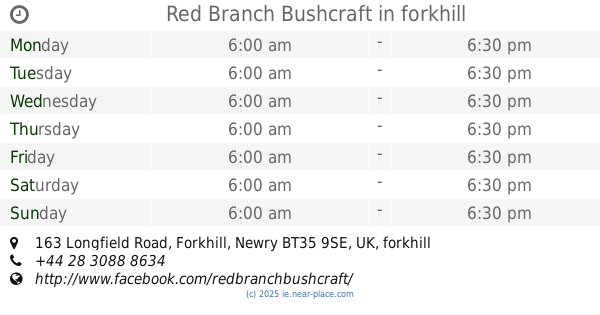
Red Branch Bushcraft
163 Longfield Road, Forkhill, Newry BT35 9SE, UK, forkhill
School
read more
2.669 km
St Oliver Plunkett's Primary School
2 Shean Road, Forkhill, Newry
School
read more
3.089 km
Jonesborough Primary School
54 The Village, Jonesborough, Newry
School
read more
3.176 km
Naiscoil Shliabh gCuilinn
02830848950 Newry BT35 8HP, UK
School
read more
4.388 km
Little Stars Day Nursery
1 Belmont Crescent, Mullaghbawn, Newry
School
read more
4.52 km
Rice School of Motoring
Raskeagh
School
read more
4.666 km
St. Mary's Primary School
17 Maphoner Road, Mullaghbawn, Newry
School
read more
4.685 km
St Joseph's Primary School Meigh
1 Seafin Road, Killeavy
School
read more
4.829 km
Scoil Phadraig Naofa
Kilcurry, Dundalk
School
read more
5.009 km
Scoil Beag Crèche and Childcare
Balriggan House, Barleyfield, Dundalk
School
read more
5.308 km
Killean Playgroup
2 Kellys Road, Killean, Newry
School
read more
5.77 km
Killean Primary School
29 Killeen School Road, Newry
School
read more
8.668 km
Saint Nicholas NS
97 Chapel Street, Dundalk
School
read more
8.92 km
CBS (Colegio ELENA)
18 Yorke Street, Dundalk
School
read more
9.137 km
Dundalk Municipal Technicial School
19 Chapel Street, Dundalk
School
read more
9.138 km
Coláiste Lú
1 Seatown, Dundalk
School
read more
10.319 km
First Steps Daycare Nursery
99-100 Upper Dromore Road, Warrenpoint, Newry
School
read more
10.778 km
Scoil Naomh Lorcan
Shore Road, Omeath
School
read more
10.823 km
Rathore School
23 Martins Lane, Newry
School
read more
11.554 km
Carrick Primary School
63 Ballydesland Road, Warrenpoint, Newry
School
read more
12.259 km
Yoga With Paddy
2 Craigmore Road, Newry
School
read more
12.457 km
The Mulberry Bush
24 Ashgrove Road, Newry
School
read more
13.765 km
Mullaglass Primary School
8 Goragh Road, Newry
School
read more
14.082 km
Blackrock National School
Saint Oliver Plunkett National School, Sandy Lane, Blackrock
School
read more
14.674 km
Scoil Cholmcille
Blackstaff National School, Carrickmacross
School
read more
📑
all categories
Accounting
Administrative area level 1
Administrative area level 2
Airport
Amusement park
Aquarium
Art gallery
Atm
Bakery
Bank
Bar
Beauty salon
Bicycle store
Book store
Bowling alley
Bus station
Cafe
Campground
Car dealer
Car rental
Car repair
Car wash
Casino
Cemetery
Church
City hall
Clothing store
Colloquial area
Convenience store
Country
Courthouse
Dentist
Department store
Doctor
Electrician
Electronics store
Embassy
Establishment
Finance
Fire station
Florist
Food
Funeral home
Furniture store
Gas station
General contractor
Grocery or supermarket
Gym
Hair care
Hardware store
Health
Hindu Temple
Home goods store
Hospital
Insurance agency
Jewelry store
Laundry
Lawyer
Library
Light rail station
Liquor store
Local government office
Locality
Locksmith
Lodging
Meal delivery
Meal takeaway
Mosque
Movie rental
Movie theater
Moving company
Museum
Natural feature
Neighborhood
Night club
Painter
Park
Parking
Pet store
Pharmacy
Physiotherapist
Place of worship
Plumber
Point of interest
Police
Political
Post office
Premise
Real estate agency
Restaurant
Roofing contractor
Route
Rv park, camping
School
Shoe store
Shopping mall
Spa
Stadium
Storage
Store
Sublocality
Subpremise
Supermarket
Synagogue
Taxi stand
Train station
Transit station
Travel agency
University
Veterinary care
Zoo
sublocality level 1
↑