School nearby Moneystown National School
Coronavirus disease (COVID-19) Situation
confirmed cases
1734582
deaths
9491
Ireland
School nearby Moneystown National School
Moneystown National School
Bray Ireland
contacts phone
:
+353
Latitude:
53.0035937
, Longitude:
-6.1991311
read more
nearest School
5.132 km
Nuns Cross National School
Ballinahinch
School
read more
5.15 km
Nuns Cross National School
Ashford
School
read more
5.709 km
The Little Farm Pre School
Laragh East, Glendalough
School
read more
6.28 km
Ashford Montessori School
R772
School
read more
7.119 km
Jennys Pre School
Moneystown Community Centre, Roundwood
School
read more
8.134 km
Tiny Tots Pre School
8A, Merrymeeting, Rathnew
School
read more
8.354 km
Paddy Power
29 Market Square, Rathdrum
School
read more
8.42 km
Butt Poo
7 Parnell Park, Rathdrum, Co. Wicklow, A67 NW58 Parnell Park, Rathdrum
School
read more
9.097 km
Coláiste Chill Mhantain
Burkeen
School
read more
9.339 km
Lilliput Childcare Rathdrum
Beechlawn, Corballis Upper, Rathdrum
School
read more
10.033 km
Naíonra Chill Mhantáin
1 Graham's Court, Wicklow
School
read more
10.079 km
Ashvale Creche
Ashvale House, Ballynerrin Upper, Wicklow
School
read more
10.323 km
Gaelscoil Chill Mhantain
Wicklow
School
read more
10.635 km
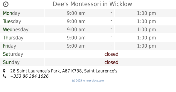
Dee's Montessori
28 Saint Laurence's Park, A67 K738 Saint Laurence's Park, Wicklow
School
read more
11.079 km
Dominican College
Wicklow
School
read more
11.095 km
Holy Rosary Secondary School
6 Crinion Park, Wicklow
School
read more
11.26 km
The Corner House Kindergarten
Old School House, Newtownmountkennedy
School
read more
11.305 km
Little Explorers Childcare
12 Mount kennedy town centre, Newtownmountkennedy
School
read more
11.614 km
Treasures' Montessori Preschool
Dunbur Road, Wicklow
School
read more
12.11 km
Smarties Pre-School
18 Glenvale Park, Wicklow
School
read more
12.859 km
Yur ma
K78 AE44, Newcastle Road
School
read more
15.1 km
Cole Potterspoint
Ballynacarrig
School
read more
15.427 km
Spruce Lodge
Ballyrogan Upper
School
read more
16.424 km
Just4keepers Wicklow
236 Charlesland Wood, Greystones
School
read more
16.829 km
Acorns Playschool
Mill Road, Greystones
School
read more
📑
all categories
Accounting
Administrative area level 1
Administrative area level 2
Airport
Amusement park
Aquarium
Art gallery
Atm
Bakery
Bank
Bar
Beauty salon
Bicycle store
Book store
Bowling alley
Bus station
Cafe
Campground
Car dealer
Car rental
Car repair
Car wash
Casino
Cemetery
Church
City hall
Clothing store
Colloquial area
Convenience store
Country
Courthouse
Dentist
Department store
Doctor
Electrician
Electronics store
Embassy
Establishment
Finance
Fire station
Florist
Food
Funeral home
Furniture store
Gas station
General contractor
Grocery or supermarket
Gym
Hair care
Hardware store
Health
Hindu Temple
Home goods store
Hospital
Insurance agency
Jewelry store
Laundry
Lawyer
Library
Light rail station
Liquor store
Local government office
Locality
Locksmith
Lodging
Meal delivery
Meal takeaway
Mosque
Movie rental
Movie theater
Moving company
Museum
Natural feature
Neighborhood
Night club
Painter
Park
Parking
Pet store
Pharmacy
Physiotherapist
Place of worship
Plumber
Point of interest
Police
Political
Post office
Premise
Real estate agency
Restaurant
Roofing contractor
Route
Rv park, camping
School
Shoe store
Shopping mall
Spa
Stadium
Storage
Store
Sublocality
Subpremise
Supermarket
Synagogue
Taxi stand
Train station
Transit station
Travel agency
University
Veterinary care
Zoo
sublocality level 1
↑