Atm nearby AIB ATM
Ireland
Atm nearby AIB ATM
AIB ATM
Mardyke Bowl, Mardyke Entertainment Complex, Sheares Street, Cork Ireland
contacts phone
:
+353
Latitude:
51.8981969
, Longitude:
-8.4814504
read more
nearest Atm
130 m
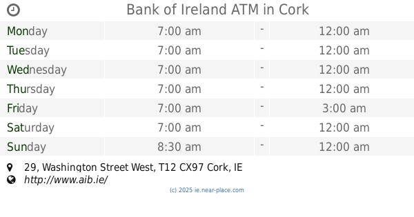
Bank of Ireland ATM
Centra, 29 Washington Street West, Cork
Atm
read more
274 m
AIB ATM
33 North Main Street, Cork
Atm
read more
321 m
Ulster Bank ATM
26 Washington Street, Cork
Atm
read more
385 m
Bank of Ireland ATM
Centra, 83 Grand Parade, Cork
Atm
read more
451 m
Bank of Ireland ATM
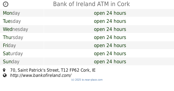
70 Saint Patrick's Street, Cork
Atm
read more
470 m
Ulster Bank ATM
29 Grand Parade, Cork
Atm
read more
472 m
ATM
R848, Centre, Cork
Atm
read more
487 m
Bank of Ireland ATM
4 Barrack Street, Cork
Atm
read more
495 m
Ulster Bank ATM
Tesco, Paul Street Shopping Centre, Paul Street, Cork
Atm
read more
595 m
Permanent TSB ATM
40/41 Saint Patrick's Street, Cork
Atm
read more
657 m
Bank of Ireland
32 S Mall, Cork
Atm
read more
659 m
AIB ATM
Marlboro Street, Cork
Atm
read more
676 m
Bank of Ireland ATM
Dunnes Stores, 105 Saint Patrick's Street, Cork
Atm
read more
691 m
AIB ATM
105 Saint Patrick's Street, Centre, Cork
Atm
read more
737 m
Ulster Bank ATM
16-17 Winthrop Street, Cork
Atm
read more
800 m
Bank of Ireland ATM
32 South Mall Street, Cork
Atm
read more
877 m
CashZone ATM
Leitrim Street, Cork
Atm
read more
883 m
ATM (Topaz)
Shandon
Atm
read more
939 m
AIB ATM
Centra, 10 Denroches Cross, Cork
Atm
read more
956 m
Bank of Ireland
University College, Cork
Atm
read more
993 m
ATM (Inside Spar)
48 MacCurtain Street, Cork
Atm
read more
993 m
ATM in Spar
48 MacCurtain Street, Cork
Atm
read more
1.013 km
YourMoneyKiosk ATM
SPAR, Cork, T23 DWN8, 48 MacCurtain Street, Montenotte, Cork
Atm
read more
1.04 km
Ulster Bank ATM
Spar, 17 Douglas Street, Centre, Cork
Atm
read more
1.104 km
ATM Daybreak
60 College Rd, The Lough, Cork, T12 HW58 College Road, The Lough, Cork
Atm
read more
📑
all categories
Accounting
Administrative area level 1
Administrative area level 2
Airport
Amusement park
Aquarium
Art gallery
Atm
Bakery
Bank
Bar
Beauty salon
Bicycle store
Book store
Bowling alley
Bus station
Cafe
Campground
Car dealer
Car rental
Car repair
Car wash
Casino
Cemetery
Church
City hall
Clothing store
Colloquial area
Convenience store
Country
Courthouse
Dentist
Department store
Doctor
Electrician
Electronics store
Embassy
Establishment
Finance
Fire station
Florist
Food
Funeral home
Furniture store
Gas station
General contractor
Grocery or supermarket
Gym
Hair care
Hardware store
Health
Hindu Temple
Home goods store
Hospital
Insurance agency
Jewelry store
Laundry
Lawyer
Library
Light rail station
Liquor store
Local government office
Locality
Locksmith
Lodging
Meal delivery
Meal takeaway
Mosque
Movie rental
Movie theater
Moving company
Museum
Natural feature
Neighborhood
Night club
Painter
Park
Parking
Pet store
Pharmacy
Physiotherapist
Place of worship
Plumber
Point of interest
Police
Political
Post office
Premise
Real estate agency
Restaurant
Roofing contractor
Route
Rv park, camping
School
Shoe store
Shopping mall
Spa
Stadium
Storage
Store
Sublocality
Subpremise
Supermarket
Synagogue
Taxi stand
Train station
Transit station
Travel agency
University
Veterinary care
Zoo
sublocality level 1
↑