Bank nearby Bank of Ireland
Ireland
Bank nearby Bank of Ireland
Bank of Ireland
1A, Main Street, P31 D521, Ballincollig, IE Irlanda
contacts phone
:
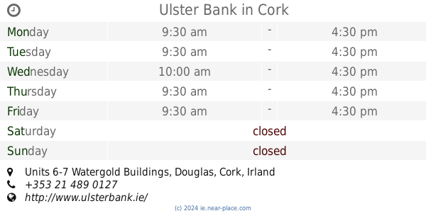
+353 21 487 1202
website:
personalbanking.bankofireland.com
Latitude:
51.8882055
, Longitude:
-8.5879849
larger map & directions
read more
nearest Bank
186 m
permanent tsb
17 Main Street, Ballincollig
Bank
read more
205 m
AIB Bank
9 Main Street, Ballincollig
Bank
read more
268 m
EBS
24 Main Street, Ballincollig
Bank
read more
3.609 km
Bank of Ireland
Cork Institute of Technology, Rossa Avenue, Bishopstown
Bank
read more
4.88 km
AIB
Bishopstown Road, Cork
Bank
read more
4.92 km
permanent tsb
1 Curraheen Road, Bishopstown, Cork
Bank
read more
5.159 km
AIB Bank
The Square, Blarney
Bank
read more
5.392 km
AIB
Western Road
Bank
read more
5.512 km
EBS
44, Wilton Shopping Centre, Wilton, Cork
Bank
read more
5.518 km
KBC Bank
43, Wilton, Co. Cork
Bank
read more
5.617 km
Bank of Ireland
Wilton Shopping Centre, Sarsfield Rd, Wilton, Cork
Bank
read more
6.424 km
AIB Bank
65 College Road, Cork
Bank
read more
7.955 km
Ulster Bank
88 Saint Patrick's Street, Cork
Bank
read more
8.038 km
AIB
66 South Mall, Cork
Bank
read more
8.084 km
AIB
26 Saint Patrick's Street, Cork
Bank
read more
8.248 km
AIB
Pearse Road, Ballyphehane, Cork
Bank
read more
8.384 km
St Gabriels Credit Union Limited
34/36 Saint Patrick's Quay, Cork
Bank
read more
8.435 km
Kbc Bank
4 Lapp's Quay, Cork
Bank
read more
8.574 km
Bank of Ireland
Blackpool Shopping Centre, Blackpool, Cork
Bank
read more
9.389 km
Finance Claims
Unit 5, Airport East Business & Technology Park, Rathmacullig West, Cork
Bank
read more
10.722 km
Ulster Bank
Units 6-7 Watergold Buildings, Douglas, Cork
Bank
read more
13.648 km
AIB
East Cliff Road
Bank
read more
13.903 km
Bank of Ireland
Hazelwood Centre, Riverstown, Glanmire
Bank
read more
15.83 km
Bank of Ireland
Main Street, Carrigaline
Bank
read more
18.054 km
Bank of Ireland
North Square, Macroom
Bank
read more
📑
all categories
Accounting
Administrative area level 1
Administrative area level 2
Airport
Amusement park
Aquarium
Art gallery
Atm
Bakery
Bank
Bar
Beauty salon
Bicycle store
Book store
Bowling alley
Bus station
Cafe
Campground
Car dealer
Car rental
Car repair
Car wash
Casino
Cemetery
Church
City hall
Clothing store
Colloquial area
Convenience store
Country
Courthouse
Dentist
Department store
Doctor
Electrician
Electronics store
Embassy
Establishment
Finance
Fire station
Florist
Food
Funeral home
Furniture store
Gas station
General contractor
Grocery or supermarket
Gym
Hair care
Hardware store
Health
Hindu Temple
Home goods store
Hospital
Insurance agency
Jewelry store
Laundry
Lawyer
Library
Light rail station
Liquor store
Local government office
Locality
Locksmith
Lodging
Meal delivery
Meal takeaway
Mosque
Movie rental
Movie theater
Moving company
Museum
Natural feature
Neighborhood
Night club
Painter
Park
Parking
Pet store
Pharmacy
Physiotherapist
Place of worship
Plumber
Point of interest
Police
Political
Post office
Premise
Real estate agency
Restaurant
Roofing contractor
Route
Rv park, camping
School
Shoe store
Shopping mall
Spa
Stadium
Storage
Store
Sublocality
Subpremise
Supermarket
Synagogue
Taxi stand
Train station
Transit station
Travel agency
University
Veterinary care
Zoo
sublocality level 1
↑