Bank nearby Santander
Ireland
Bank nearby Santander
Santander
67, Hill Street, BT34 1AF, Newry, Newry and Mourne, GB Reino Unido
contacts phone
:
+44 800 030 4321
website:
www.santander.co.uk
Latitude:
54.176004
, Longitude:
-6.3375915
larger map & directions
read more
nearest Bank
37 m
Newry Credit Union
County Down, 72 Hill Street, Newry
Bank
read more
59 m
Ulster Bank
86 Hill Street, Newry
Bank
read more
73 m
Danske Bank
58 Hill Street, Newry
Bank
read more
154 m
First Trust Bank
42-44 Hill Street, Newry
Bank
read more
203 m
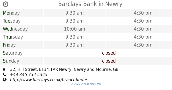
Barclays Bank
32 Hill Street, Newry
Bank
read more
332 m
Bank of Ireland
12 Trevor Hill, Newry
Bank
read more
569 m
Halifax
53a, Buttercrane Quay, Newry
Bank
read more
569 m
Halifax
53a, Buttercrane Shopping Centre, Buttercrane Quay, Newry
Bank
read more
2.913 km
First Trust Bank
Newry
Bank
read more
9.9 km
Ulster Bank
2 Charlotte Street, Warrenpoint, Newry
Bank
read more
17.836 km
AIB
Newry Street, Liberties of Carlingford, Carlingford
Bank
read more
17.989 km
AIB ATM Banklink
Carlingford
Bank
read more
19.347 km
Bank of Ireland
81 Clanbrassil Street, Dundalk
Bank
read more
19.496 km
AIB Bank
96 Clanbrassil Street, Dundalk
Bank
read more
19.499 km
permanent tsb
1-3 Clanbrassil Street, Dundalk
Bank
read more
19.515 km
Ulster Bank
100 Clanbrassil Street, Dundalk
Bank
read more
20.73 km
Bank of Ireland
53 Newry Road, Crossmaglen, Newry
Bank
read more
21.618 km
AIB Bank
Unit 1, Dundalk IT, Marshes Lower, Dundalk
Bank
read more
21.797 km
Allied Irish Banks Plc
Dundalk Institute of Technology, Dublin Road, Dundalk
Bank
read more
23.598 km
Blackrock Post Office
Centra, Main Street, Blackrock Village, Dundalk
Bank
read more
28.308 km
Danske Bank
45-48 High Street, Portadown, Craigavon
Bank
read more
33.312 km
Bank of Ireland
Main Street, Carrickmacross
Bank
read more
33.398 km
AIB Bank
31 Main Street, Carrickmacross
Bank
read more
45.166 km
Collon Credit Union
Collon
Bank
read more
61.078 km
Bank of Ireland
John Street, Kells
Bank
read more
📑
all categories
Accounting
Administrative area level 1
Administrative area level 2
Airport
Amusement park
Aquarium
Art gallery
Atm
Bakery
Bank
Bar
Beauty salon
Bicycle store
Book store
Bowling alley
Bus station
Cafe
Campground
Car dealer
Car rental
Car repair
Car wash
Casino
Cemetery
Church
City hall
Clothing store
Colloquial area
Convenience store
Country
Courthouse
Dentist
Department store
Doctor
Electrician
Electronics store
Embassy
Establishment
Finance
Fire station
Florist
Food
Funeral home
Furniture store
Gas station
General contractor
Grocery or supermarket
Gym
Hair care
Hardware store
Health
Hindu Temple
Home goods store
Hospital
Insurance agency
Jewelry store
Laundry
Lawyer
Library
Light rail station
Liquor store
Local government office
Locality
Locksmith
Lodging
Meal delivery
Meal takeaway
Mosque
Movie rental
Movie theater
Moving company
Museum
Natural feature
Neighborhood
Night club
Painter
Park
Parking
Pet store
Pharmacy
Physiotherapist
Place of worship
Plumber
Point of interest
Police
Political
Post office
Premise
Real estate agency
Restaurant
Roofing contractor
Route
Rv park, camping
School
Shoe store
Shopping mall
Spa
Stadium
Storage
Store
Sublocality
Subpremise
Supermarket
Synagogue
Taxi stand
Train station
Transit station
Travel agency
University
Veterinary care
Zoo
sublocality level 1
↑