Bar nearby Baggots Back Door
Ireland
Bar nearby Baggots Back Door
Baggots Back Door
The Square, Clara, IE Irlandia
contacts phone
:
+353 57 933 1239
website:
baggots-back-door.business.site
Latitude:
53.3439011
, Longitude:
-7.61394
larger map & directions
read more
nearest Bar
124 m
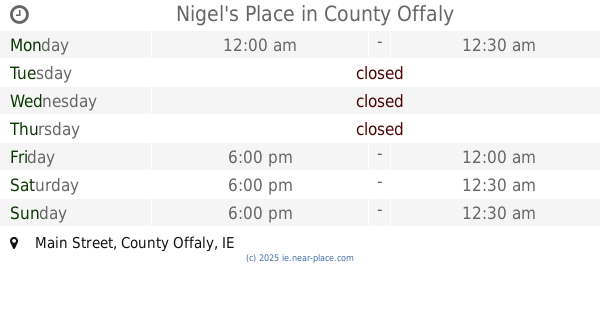
Nigel's Place
Main Street, Kilcoursey
Bar
read more
132 m
The Mill Bar & Restaurant
River Street, Clara
Bar
read more
264 m
Christy Cowens Pub
River Street, Clara
Bar
read more
4.845 km
Cat And Bagpipes Pub
Tober, Moate
Bar
read more
8.123 km
The Saddler's Inn
53°22'05.4"N 7°29'54.5"W
Bar
read more
8.272 km
McNamara's Lounge
53°22'03.8"N 7°29'45.0"W
Bar
read more
8.883 km
Dr Cuppaige's (The Tanyard) Pub
2-4 Main Street, Cartronkeel
Bar
read more
8.896 km
Don's Bar
2-4 Main Street, Cartronkeel
Bar
read more
8.929 km
Vincent Coghlan's Pub
3-5 R446, Cartronkeel
Bar
read more
8.964 km
Peadar's Bar
6 Main Street, Cartronkeel
Bar
read more
9.197 km
Egans
Main Street, Moate
Bar
read more
9.53 km
Carryout Off-Licence
Church Street, Moate
Bar
read more
9.545 km
The Gap House
Church Street, Moate
Bar
read more
9.65 km
The Pull Inn
53.278453, -7.709382
Bar
read more
10.81 km
The Lantern bar
7-, 9 Kilbride Street, Tullamore
Bar
read more
11.04 km
Bob Smyth's Bar
Patrick Street, Tullamore
Bar
read more
11.159 km
The Old Harbour Bar
Harbour Street, Tullamore
Bar
read more
11.171 km
Gallaghers Manor
Church Street, Tullamore
Bar
read more
11.19 km
Fergie's Bar and Lounge
Market Square, Tullamore
Bar
read more
11.215 km
The Townhouse Tullamore
High Street, Tullamore
Bar
read more
13.138 km
Maunsells Bar & Lounge
Cloncollig, Tullamore
Bar
read more
13.526 km
The Hazel Pub
New Rd
Bar
read more
13.901 km
Martin's Of Doon
Doon, Ballynahown
Bar
read more
14.118 km
Egans Pub
Mount Temple House, Moate
Bar
read more
18.106 km
Doyle's Pub
L2001
Bar
read more
📑
all categories
Accounting
Administrative area level 1
Administrative area level 2
Airport
Amusement park
Aquarium
Art gallery
Atm
Bakery
Bank
Bar
Beauty salon
Bicycle store
Book store
Bowling alley
Bus station
Cafe
Campground
Car dealer
Car rental
Car repair
Car wash
Casino
Cemetery
Church
City hall
Clothing store
Colloquial area
Convenience store
Country
Courthouse
Dentist
Department store
Doctor
Electrician
Electronics store
Embassy
Establishment
Finance
Fire station
Florist
Food
Funeral home
Furniture store
Gas station
General contractor
Grocery or supermarket
Gym
Hair care
Hardware store
Health
Hindu Temple
Home goods store
Hospital
Insurance agency
Jewelry store
Laundry
Lawyer
Library
Light rail station
Liquor store
Local government office
Locality
Locksmith
Lodging
Meal delivery
Meal takeaway
Mosque
Movie rental
Movie theater
Moving company
Museum
Natural feature
Neighborhood
Night club
Painter
Park
Parking
Pet store
Pharmacy
Physiotherapist
Place of worship
Plumber
Point of interest
Police
Political
Post office
Premise
Real estate agency
Restaurant
Roofing contractor
Route
Rv park, camping
School
Shoe store
Shopping mall
Spa
Stadium
Storage
Store
Sublocality
Subpremise
Supermarket
Synagogue
Taxi stand
Train station
Transit station
Travel agency
University
Veterinary care
Zoo
sublocality level 1
↑