Bar nearby Bennett's Bar & Lounge
Ireland
Bar nearby Bennett's Bar & Lounge
Bennett's Bar & Lounge
Ardcath Hall, Ardcath, Co. Meath, Irland
contacts phone
:
+353 1 835 4118
website:
www.facebook.com
Latitude:
53.6077187
, Longitude:
-6.392769
larger map & directions
read more
nearest Bar
2.995 km
Donnellys Pub
Unnamed Rd, Co.
Bar
read more
3.04 km
Donnellys Pub
Clogherstown, Clonalvy
Bar
read more
4.126 km
The Becks
Cushenstown, Garristown
Bar
read more
4.991 km
bellewstown inn
Unnamed Road, Collierstown
Bar
read more
4.993 km
the hill bar
Collierstown
Bar
read more
10.182 km
Coffee Court
Ashbourne Industrial Estate, Ashbourne
Bar
read more
10.534 km
Oldtown House
4 The Orchard, Oldtown
Bar
read more
10.565 km
Molly's Bar
Frederick Street, Ashbourne
Bar
read more
10.691 km
Mancinis Urban
Unit 1 Killegland House, Killegland Street, Ashbourne
Bar
read more
10.692 km
Mancinis Urban
1, 1 Killegland Court, Killegland, Ashbourne
Bar
read more
10.712 km
The Balscadden Inn
Commons (2nd Division)
Bar
read more
10.716 km
Swan Bar
Colvinstown
Bar
read more
10.853 km
Fogarty's Bar
6 Ashbourne Road, Bellewstown Bridge
Bar
read more
11.309 km
McKeever's Pub
Skerrymount House, Navan
Bar
read more
12.282 km
The Hamlet Pub
Castlemills Centre, Hamlet Lane, Balbriggan
Bar
read more
12.284 km
Donaghy's Bar
7 Trinity Street, Drogheda
Bar
read more
12.35 km
The Punt
51 Fair Street, Downtown Drogheda, Drogheda
Bar
read more
12.378 km
The Cross
10-, 20 George's Street, Drogheda
Bar
read more
12.414 km
Sarsfield's
97 east, 125 Cord Road, Drogheda
Bar
read more
12.487 km
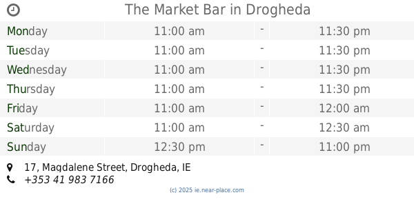
The Market Bar
17 Magdalene Street, Drogheda
Bar
read more
13.699 km
The Milestone
Drogheda Street, Balbriggan
Bar
read more
14.461 km
The Morning Star
Main Road, Tullyallen
Bar
read more
14.551 km
An Sibin
Main Street, Dunshaughlin
Bar
read more
14.678 km
Man o' War Bar and Restaurant
Courtlough, Balbriggan
Bar
read more
16.61 km
The 19th Bar
Baltray
Bar
read more
📑
all categories
Accounting
Administrative area level 1
Administrative area level 2
Airport
Amusement park
Aquarium
Art gallery
Atm
Bakery
Bank
Bar
Beauty salon
Bicycle store
Book store
Bowling alley
Bus station
Cafe
Campground
Car dealer
Car rental
Car repair
Car wash
Casino
Cemetery
Church
City hall
Clothing store
Colloquial area
Convenience store
Country
Courthouse
Dentist
Department store
Doctor
Electrician
Electronics store
Embassy
Establishment
Finance
Fire station
Florist
Food
Funeral home
Furniture store
Gas station
General contractor
Grocery or supermarket
Gym
Hair care
Hardware store
Health
Hindu Temple
Home goods store
Hospital
Insurance agency
Jewelry store
Laundry
Lawyer
Library
Light rail station
Liquor store
Local government office
Locality
Locksmith
Lodging
Meal delivery
Meal takeaway
Mosque
Movie rental
Movie theater
Moving company
Museum
Natural feature
Neighborhood
Night club
Painter
Park
Parking
Pet store
Pharmacy
Physiotherapist
Place of worship
Plumber
Point of interest
Police
Political
Post office
Premise
Real estate agency
Restaurant
Roofing contractor
Route
Rv park, camping
School
Shoe store
Shopping mall
Spa
Stadium
Storage
Store
Sublocality
Subpremise
Supermarket
Synagogue
Taxi stand
Train station
Transit station
Travel agency
University
Veterinary care
Zoo
sublocality level 1
↑