Bar nearby JP Clarke's
Ireland
Bar nearby JP Clarke's
JP Clarke's
Old Bunratty Road, V94 KD73, Bunratty, IE Irland
contacts phone
:
+353 61 363 363
website:
www.jpclarkes.ie
Latitude:
52.699187
, Longitude:
-8.815838
larger map & directions
read more
nearest Bar
328 m
The Creamery Bar
1 Castle Gardens, Bunratty
Bar
read more
346 m
The Creamery Bar
Old Bunratty Road, Bunratty
Bar
read more
409 m
The Original Durty Nelly's
Bunratty
Bar
read more
409 m
Durty Nelly's
Bunratty
Bar
read more
3.717 km
The Goalpost
4 Gleann An Oir, Tullyvarraga, Shannon
Bar
read more
3.935 km
Setrights Tavern
Laghile
Bar
read more
4.528 km
Shannon Knights
Shannon Town Centre, Shannon
Bar
read more
5.371 km
Crossroads Tavern
Drumgeely, Shannon
Bar
read more
5.403 km
McGregors Bar & Bistro
Sixmilebridge
Bar
read more
5.511 km
Gillys Bar
17 Church Street, Sixmilebridge
Bar
read more
5.526 km
Caseys Bar
Main Street, Sixmilebridge
Bar
read more
5.567 km
Old House Pub
The Square,, Sixmilebridge
Bar
read more
5.702 km
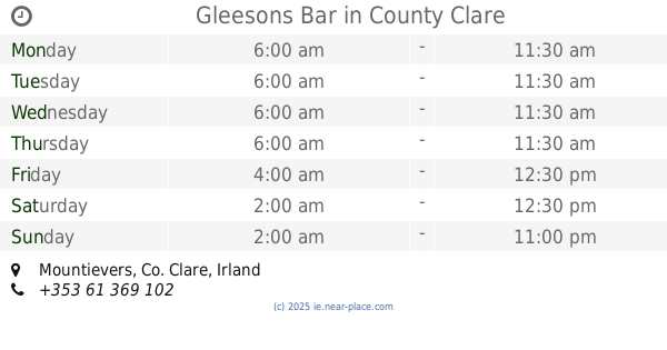
Gleesons Bar
Mountievers
Bar
read more
12.965 km
South Court Hotel
Raheen Roundabout, Raheen, Limerick
Bar
Lodging
Restaurant
Food
Point of interest
Establishment
read more
12.966 km
South Court Hotel
Raheen, Limerick
Bar
read more
13.164 km
South's Pub
4 Quinlan Street, Limerick
Bar
read more
13.217 km
Pharmacia
8 Sarsfield Street, Limerick
Bar
read more
13.355 km
Tom Collins
34 Cecil Street, Limerick
Bar
read more
13.411 km
The Dark Horse Bar
Main st Barnakyle Patrickswell Co. Limerick IE V94HW9H, Main Street, Patrickswell
Bar
read more
13.448 km
Clohessy's Bar
Denmark Street, Limerick
Bar
read more
13.54 km
Nancy Blakes
19 Upper Denmark Street, Limerick
Bar
read more
13.824 km
The Grove Gastro Pub
corbally centre, Corbally Road, Limerick
Bar
read more
13.914 km
The Horse and Hound Bar
1 Mulgrave Street, Limerick
Bar
read more
17.059 km
Danny's Bar
Main Street, Broadford
Bar
read more
18.349 km
Halfway House
Clare Road, Ennis
Bar
read more
📑
all categories
Accounting
Administrative area level 1
Administrative area level 2
Airport
Amusement park
Aquarium
Art gallery
Atm
Bakery
Bank
Bar
Beauty salon
Bicycle store
Book store
Bowling alley
Bus station
Cafe
Campground
Car dealer
Car rental
Car repair
Car wash
Casino
Cemetery
Church
City hall
Clothing store
Colloquial area
Convenience store
Country
Courthouse
Dentist
Department store
Doctor
Electrician
Electronics store
Embassy
Establishment
Finance
Fire station
Florist
Food
Funeral home
Furniture store
Gas station
General contractor
Grocery or supermarket
Gym
Hair care
Hardware store
Health
Hindu Temple
Home goods store
Hospital
Insurance agency
Jewelry store
Laundry
Lawyer
Library
Light rail station
Liquor store
Local government office
Locality
Locksmith
Lodging
Meal delivery
Meal takeaway
Mosque
Movie rental
Movie theater
Moving company
Museum
Natural feature
Neighborhood
Night club
Painter
Park
Parking
Pet store
Pharmacy
Physiotherapist
Place of worship
Plumber
Point of interest
Police
Political
Post office
Premise
Real estate agency
Restaurant
Roofing contractor
Route
Rv park, camping
School
Shoe store
Shopping mall
Spa
Stadium
Storage
Store
Sublocality
Subpremise
Supermarket
Synagogue
Taxi stand
Train station
Transit station
Travel agency
University
Veterinary care
Zoo
sublocality level 1
↑