Bar nearby Preachers Pub
Ireland
Bar nearby Preachers Pub
Preachers Pub
6-10, O'Connell Street, V95 PX64, Ennis, IE Ireland
contacts phone
:
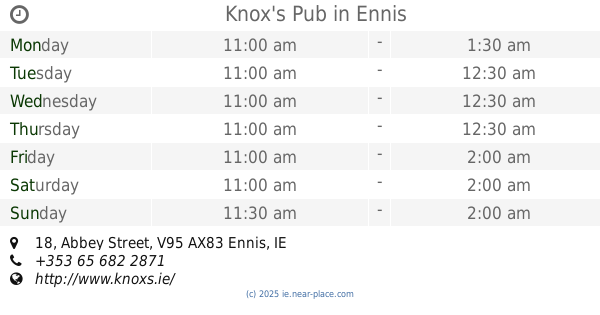
+353 65 682 3300
website:
www.templegatehotel.com
Latitude:
52.8437023
, Longitude:
-8.9816517
larger map & directions
read more
nearest Bar
98 m
The Diamond Bar
25 O'Connell Street, Ennis
Bar
read more
144 m
Paddy Quinn
36 Lower Market St, Clonroad Beg, Ennis, Co. Clare, V95 HW72 Lower Market Street, Clonroad Beg, Ennis
Bar
read more
146 m
Knox's Pub
18 Abbey Street, Ennis
Bar
read more
148 m
Quinns
7 Lower Market Street, Ennis
Bar
read more
158 m
Nora Culligans
26 Abbey St, Ennis, Co. Clare, V95 T446 Abbey Street, Ennis
Bar
read more
160 m
Moroney's Bar
9 Lower Market Street, Ennis
Bar
read more
167 m
Ciaran's Bar
2 Francis Street, Lifford, Ennis
Bar
read more
171 m
The market
3 Merchants Square, Clonroad Beg, Ennis
Bar
read more
172 m
Brian Kelly's Bar
11A Lower Market Street, Ennis
Bar
read more
181 m
Faffa Considines
15 Parnell Street, Ennis
Bar
read more
187 m
Queens Hotel
Abbey Street, Ennis
Bar
read more
208 m
Yolo Bar & Restaurant
42 Abbey Street, Ennis
Bar
read more
215 m
Fawls Bar
69 O'Connell Street, Ennis
Bar
read more
267 m
O' Deas
64 O'Connell Street, Ennis
Bar
read more
271 m
O' Deas
66 O'Connell Street, Clonroad Beg, Ennis
Bar
read more
273 m
Taylors Bar
Lower Market Street, Clonroad Beg, Ennis
Bar
read more
286 m
Griffin's Bar
60 Parnell Street, Ennis
Bar
read more
353 m
Lucas Bar
74 Parnell Street, Ennis
Bar
read more
381 m
McHugh's Bar
78 Parnell Street, Ennis
Bar
read more
415 m
Kellys
5 Carmody Street, Ennis
Bar
read more
439 m
The Local
1 Newbridge Road, Lifford, Ennis
Bar
read more
456 m
Tom Steele's Bar
Lifford, Ennis
Bar
read more
481 m
James O'Keefe's
Lifford, Ennis
Bar
read more
518 m
Copper Jug
Courtview, Lifford, Ennis
Bar
read more
763 m
Gleeson's Bar
Turnpike Road, County Clare
Bar
read more
📑
all categories
Accounting
Administrative area level 1
Administrative area level 2
Airport
Amusement park
Aquarium
Art gallery
Atm
Bakery
Bank
Bar
Beauty salon
Bicycle store
Book store
Bowling alley
Bus station
Cafe
Campground
Car dealer
Car rental
Car repair
Car wash
Casino
Cemetery
Church
City hall
Clothing store
Colloquial area
Convenience store
Country
Courthouse
Dentist
Department store
Doctor
Electrician
Electronics store
Embassy
Establishment
Finance
Fire station
Florist
Food
Funeral home
Furniture store
Gas station
General contractor
Grocery or supermarket
Gym
Hair care
Hardware store
Health
Hindu Temple
Home goods store
Hospital
Insurance agency
Jewelry store
Laundry
Lawyer
Library
Light rail station
Liquor store
Local government office
Locality
Locksmith
Lodging
Meal delivery
Meal takeaway
Mosque
Movie rental
Movie theater
Moving company
Museum
Natural feature
Neighborhood
Night club
Painter
Park
Parking
Pet store
Pharmacy
Physiotherapist
Place of worship
Plumber
Point of interest
Police
Political
Post office
Premise
Real estate agency
Restaurant
Roofing contractor
Route
Rv park, camping
School
Shoe store
Shopping mall
Spa
Stadium
Storage
Store
Sublocality
Subpremise
Supermarket
Synagogue
Taxi stand
Train station
Transit station
Travel agency
University
Veterinary care
Zoo
sublocality level 1
↑