Bar nearby The Fields Bar
Ireland
Bar nearby The Fields Bar
The Fields Bar
Old Church Street, Athenry Irlandia
contacts phone
:
+353
Latitude:
53.2979853
, Longitude:
-8.7489928
read more
nearest Bar
119 m
J Glynns
Old Church Street, Athenry
Bar
read more
131 m
The Square Inn
Cross Street, Athenry
Bar
read more
149 m
The Hop Inn
Gorteenacra
Bar
read more
175 m
Ray Glenn'sPub
Davis Street, Athenry
Bar
read more
206 m
Dan's Bar
North Gate Street, Athenry
Bar
read more
234 m
Dowling's Pub
North Gate Street, Athenry
Bar
read more
5.67 km
Lafferty's Pub
Cahertymore, Athenry
Bar
read more
7.764 km
Mary Wards Pub
Clogharevaun
Bar
read more
10.71 km
The Shebeen
Clarinbridge Business Park, Clarinbridge
Bar
read more
11.67 km
Fallons Bar Turloughmore
Turloughmore Common
Bar
read more
12.324 km
Glynn's Bar
Dublin Road, Oranmore
Bar
read more
12.393 km
The Thatch / McDonaghs
Main Street, Oranmore
Bar
read more
12.709 km
O'Donoghues Bar & B&B
Tyrone Avenue
Bar
read more
13.16 km
Mitchells Bar
Gurteen Post Office, Ballinasloe
Bar
read more
13.571 km
Burkes Bar
Colemanstown, Cuddoo
Bar
read more
13.881 km
Claregalway Hotel
Claregalway
Bar
Lodging
Restaurant
Point of interest
Food
Establishment
read more
16.14 km
An Síbín
25-, Dunkellin St Dunkellin Street, Loughrea
Bar
read more
16.24 km
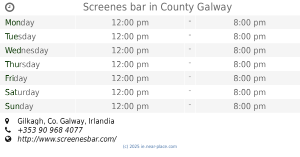
Screenes bar
Gilkagh
Bar
read more
16.31 km
Whiskey Joe's
12 Main Street, Loughrea
Bar
read more
16.317 km
Keary’s Bar
Main Street, Loughrea, Galway
Bar
read more
16.342 km
Charlies Bar
Main Street, Loughrea
Bar
read more
16.372 km
The Auld Triangle
Barrack Street, Loughrea
Bar
read more
16.459 km
McNamee's
H62 XW92, 12 Bride Street, Loughrea
Bar
read more
16.463 km
Arch Bar
Barrack Street, Loughrea
Bar
read more
17.623 km
Peggys Bar and Restaurant
Aucloggeen, Claregalway
Bar
read more
📑
all categories
Accounting
Administrative area level 1
Administrative area level 2
Airport
Amusement park
Aquarium
Art gallery
Atm
Bakery
Bank
Bar
Beauty salon
Bicycle store
Book store
Bowling alley
Bus station
Cafe
Campground
Car dealer
Car rental
Car repair
Car wash
Casino
Cemetery
Church
City hall
Clothing store
Colloquial area
Convenience store
Country
Courthouse
Dentist
Department store
Doctor
Electrician
Electronics store
Embassy
Establishment
Finance
Fire station
Florist
Food
Funeral home
Furniture store
Gas station
General contractor
Grocery or supermarket
Gym
Hair care
Hardware store
Health
Hindu Temple
Home goods store
Hospital
Insurance agency
Jewelry store
Laundry
Lawyer
Library
Light rail station
Liquor store
Local government office
Locality
Locksmith
Lodging
Meal delivery
Meal takeaway
Mosque
Movie rental
Movie theater
Moving company
Museum
Natural feature
Neighborhood
Night club
Painter
Park
Parking
Pet store
Pharmacy
Physiotherapist
Place of worship
Plumber
Point of interest
Police
Political
Post office
Premise
Real estate agency
Restaurant
Roofing contractor
Route
Rv park, camping
School
Shoe store
Shopping mall
Spa
Stadium
Storage
Store
Sublocality
Subpremise
Supermarket
Synagogue
Taxi stand
Train station
Transit station
Travel agency
University
Veterinary care
Zoo
sublocality level 1
↑