Bar nearby The Firhouse Inn
Ireland
Bar nearby The Firhouse Inn
The Firhouse Inn
The Firhouse Inn, Firhouse Road, Dublin 24 Irlandia
contacts phone
:
+353
Latitude:
53.2866918
, Longitude:
-6.3319844
read more
nearest Bar
266 m
Delaney's Public House
Knocklyon
Bar
read more
267 m
The Knocklyon Inn
Knocklyon Road, Dublin
Bar
read more
554 m
Peach Tree
Tallaght Road, Dublin
Bar
read more
803 m
The Speaker Connolly
Firhouse Road, Firhouse
Bar
read more
921 m
D'Arcy McGees
Wellington Ln, Templeogue, Dublin 6W
Bar
read more
1.204 km
Penny Black Taverns
Castletymon Road, Tymon North, Dublin
Bar
read more
1.208 km
The Penny Black
Castletymon Road, Dublin
Bar
read more
1.567 km
Scholars Pub
Oldcourt Shopping Centre, Parklands Road, Dublin 24
Bar
read more
1.744 km
The Blue Haven
1 Ballyroan Road, Rathfarnham, Dublin
Bar
read more
1.824 km
The Station at Molloy's
Village Green, Tallaght, Dublin
Bar
read more
1.836 km
Molloys Bar & Grill
24 Main Street, Tallaght, Dublin
Bar
read more
1.955 km
The Old Mill Bar
Old Bawn Road, Tallaght, Dublin 24
Bar
read more
1.999 km
Ahernes
Old Bawn Road, Dublin
Bar
read more
2.281 km
The Traders
Saint James's Road, Dublin
Bar
read more
2.329 km
Orchard Cabs
The Old Orchard Pub, Butterfield Avenue, Rathfranham, Dublin 14
Bar
read more
2.33 km
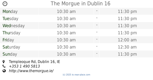
The Morgue
Templeogue Rd, Templeogue, Dublin 16
Bar
read more
2.354 km
Grumpy McClaffertys
The Plaza Complex, Belgard Square South, Dublin
Bar
read more
2.382 km
Mc Claffertys
Plaza Hotel, Tallaght, Dublin
Bar
read more
2.453 km
The Pines
Whitehall Road, Dublin
Bar
read more
2.49 km
The Laurels Perrystown
186 Whitehall Road West, Perrystown, Dublin 12
Bar
read more
2.601 km
Glenville Pitch and Putt Club
Kiltipper Road, Killininny, Dublin
Bar
read more
2.922 km
Rorys House of Pain
174 Whitecliff, Rathfarnham, Dublin 16
Bar
read more
3.027 km
Calmount
Greenhills
Bar
read more
3.305 km
The Kingswood Lodge
Ballymount Road, Dublin
Bar
read more
3.404 km
The Merry Ploughboy
463-619 Edmondstown Road, Newtown
Bar
read more
📑
all categories
Accounting
Administrative area level 1
Administrative area level 2
Airport
Amusement park
Aquarium
Art gallery
Atm
Bakery
Bank
Bar
Beauty salon
Bicycle store
Book store
Bowling alley
Bus station
Cafe
Campground
Car dealer
Car rental
Car repair
Car wash
Casino
Cemetery
Church
City hall
Clothing store
Colloquial area
Convenience store
Country
Courthouse
Dentist
Department store
Doctor
Electrician
Electronics store
Embassy
Establishment
Finance
Fire station
Florist
Food
Funeral home
Furniture store
Gas station
General contractor
Grocery or supermarket
Gym
Hair care
Hardware store
Health
Hindu Temple
Home goods store
Hospital
Insurance agency
Jewelry store
Laundry
Lawyer
Library
Light rail station
Liquor store
Local government office
Locality
Locksmith
Lodging
Meal delivery
Meal takeaway
Mosque
Movie rental
Movie theater
Moving company
Museum
Natural feature
Neighborhood
Night club
Painter
Park
Parking
Pet store
Pharmacy
Physiotherapist
Place of worship
Plumber
Point of interest
Police
Political
Post office
Premise
Real estate agency
Restaurant
Roofing contractor
Route
Rv park, camping
School
Shoe store
Shopping mall
Spa
Stadium
Storage
Store
Sublocality
Subpremise
Supermarket
Synagogue
Taxi stand
Train station
Transit station
Travel agency
University
Veterinary care
Zoo
sublocality level 1
↑