Bar nearby The Greyhound Bar
Ireland
Bar nearby The Greyhound Bar
The Greyhound Bar
Main Street, County Meath, IE Ireland
contacts phone
:
+353
Latitude:
53.6544303
, Longitude:
-6.4175887
larger map & directions
read more
nearest Bar
2.27 km
Carranstown Lodge
Drogheda Rd, Duleek
Bar
read more
4.212 km
Dalys Inn
Staleen Road
Bar
read more
4.728 km
bellewstown inn
Unnamed Road, Collierstown
Bar
read more
4.741 km
the hill bar
Collierstown
Bar
read more
5.56 km
Harvest Distilling and Brewing
Platin Road, Drogheda
Bar
read more
7.718 km
McKeever's Pub
Skerrymount House, Navan
Bar
read more
7.877 km
D'Vine Bistro & Tapas Bar
Distillery House, Dyer Street, Drogheda
Bar
read more
7.916 km
Donaghy's Bar
7 Trinity Street, Drogheda
Bar
read more
7.933 km
JB's
80-81 West Street, Ballsgrove, Drogheda
Bar
read more
8.021 km
The Cross
10-, 20 George's Street, Drogheda
Bar
read more
8.031 km
The Punt
51 Fair Street, Downtown Drogheda, Drogheda
Bar
read more
8.093 km
Eastern Seaboard Bar & Grill
Bryanstown Cross Route, Bryanstown, Drogheda
Bar
read more
8.236 km
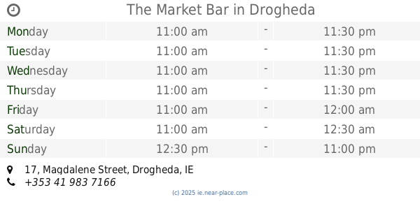
The Market Bar
17 Magdalene Street, Drogheda
Bar
read more
8.285 km
Sarsfield's
97 east, 125 Cord Road, Drogheda
Bar
read more
9.165 km
The Morning Star
Main Road, Tullyallen
Bar
read more
11.542 km
Morans Pub
Church Road, Mornington, Donacarney
Bar
read more
12.067 km
Swan Bar
Colvinstown
Bar
read more
12.13 km
Coast Tavern
3 Strand Road, Corballis, Laytown
Bar
read more
12.171 km
McDonough's Bar
Bettystown
Bar
read more
12.419 km
Reddans Bar and B&B
Coast Road, Bettystown
Bar
read more
12.932 km
The Balscadden Inn
Commons (2nd Division)
Bar
read more
13.51 km
The 19th Bar
Baltray
Bar
read more
13.811 km
Whelans-Keoghs
Tullyard
Bar
read more
14.621 km
The Hamlet Pub
Castlemills Centre, Hamlet Lane, Balbriggan
Bar
read more
15.904 km
Oldtown House
4 The Orchard, Oldtown
Bar
read more
📑
all categories
Accounting
Administrative area level 1
Administrative area level 2
Airport
Amusement park
Aquarium
Art gallery
Atm
Bakery
Bank
Bar
Beauty salon
Bicycle store
Book store
Bowling alley
Bus station
Cafe
Campground
Car dealer
Car rental
Car repair
Car wash
Casino
Cemetery
Church
City hall
Clothing store
Colloquial area
Convenience store
Country
Courthouse
Dentist
Department store
Doctor
Electrician
Electronics store
Embassy
Establishment
Finance
Fire station
Florist
Food
Funeral home
Furniture store
Gas station
General contractor
Grocery or supermarket
Gym
Hair care
Hardware store
Health
Hindu Temple
Home goods store
Hospital
Insurance agency
Jewelry store
Laundry
Lawyer
Library
Light rail station
Liquor store
Local government office
Locality
Locksmith
Lodging
Meal delivery
Meal takeaway
Mosque
Movie rental
Movie theater
Moving company
Museum
Natural feature
Neighborhood
Night club
Painter
Park
Parking
Pet store
Pharmacy
Physiotherapist
Place of worship
Plumber
Point of interest
Police
Political
Post office
Premise
Real estate agency
Restaurant
Roofing contractor
Route
Rv park, camping
School
Shoe store
Shopping mall
Spa
Stadium
Storage
Store
Sublocality
Subpremise
Supermarket
Synagogue
Taxi stand
Train station
Transit station
Travel agency
University
Veterinary care
Zoo
sublocality level 1
↑