Bar nearby The Hill Pub
Ireland
Bar nearby The Hill Pub
The Hill Pub
1 Old Mountpleasant, Dublin 6 Irland
contacts phone
:
+353
Latitude:
53.3266768
, Longitude:
-6.258303
read more
nearest Bar
481 m
Smyths of Ranelagh
75-77 Ranelagh, Dublin 6
Bar
read more
524 m
La Bodega
93 Ranelagh, Dublin 6
Bar
read more
548 m
The Bowery
196 Rathmines Road Lower, Rathmines, Dublin
Bar
read more
672 m
The Leeson Lounge
148 Leeson Street Upper, Dublin
Bar
read more
750 m
Voici Crêperie & Wine Bar
1A Rathgar Road Dublin 6
Bar
read more
759 m
Grace's
2 Rathgar Road, Dublin Southside, Rathmines
Bar
read more
760 m
Bar i dublin
21 Harcourt Road, Saint Kevin's, Dublin
Bar
read more
768 m
Grace's Bar & Lounge
2 Rathgar Road, Dublin 6
Bar
read more
775 m
Rody Bolands
12-14 Rathmines Road Upper, Rathmines
Bar
read more
795 m
Mother Reillys
26-30 Upper Rathmines Rd, Rathmines, Dublin 6
Bar
read more
801 m
Odeon
Old Railway Station 2, 57 Harcourt Street, Dublin 2
Bar
read more
801 m
Odeon
57 Harcourt Street, Dublin 2
Bar
read more
839 m
The Stone Leaf
67 Leeson Street Lower, Dublin 2
Bar
read more
845 m
House Dublin
27 Leeson Street Lower, Dublin 2
Bar
read more
866 m
The Amber Rooms Bar & Club
Leeson Street Lower, Dublin
Bar
read more
871 m
Bleeding Horse (The)
24-25 Camden Street Upper, Dublin 2
Bar
read more
871 m
The Bleeding Horse
24-25 Camden Street Upper, Dublin 2
Bar
read more
897 m
D Two
60 Harcourt Street, Dublin 2
Bar
read more
911 m
Lemuel's
Earlsfort Terrace, Dublin 2
Bar
read more
957 m
Sitting Room at Delahunt
39 Camden Street Lower, Saint Kevin's, Dublin
Bar
read more
1.029 km
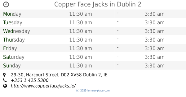
Copper Face Jacks
29-30 Harcourt Street, Dublin 2
Bar
read more
1.056 km
Mespil Hotel
50-60 Mespil Road, Dublin 4
Bar
read more
1.094 km
Devitts Pub
78 Camden Street Lower, Dublin 2
Bar
read more
1.234 km
Saba
22 Baggot Street Upper, Dublin 4
Bar
read more
1.337 km
Smyths Pub
10 Haddington Road, Dublin 4
Bar
read more
📑
all categories
Accounting
Administrative area level 1
Administrative area level 2
Airport
Amusement park
Aquarium
Art gallery
Atm
Bakery
Bank
Bar
Beauty salon
Bicycle store
Book store
Bowling alley
Bus station
Cafe
Campground
Car dealer
Car rental
Car repair
Car wash
Casino
Cemetery
Church
City hall
Clothing store
Colloquial area
Convenience store
Country
Courthouse
Dentist
Department store
Doctor
Electrician
Electronics store
Embassy
Establishment
Finance
Fire station
Florist
Food
Funeral home
Furniture store
Gas station
General contractor
Grocery or supermarket
Gym
Hair care
Hardware store
Health
Hindu Temple
Home goods store
Hospital
Insurance agency
Jewelry store
Laundry
Lawyer
Library
Light rail station
Liquor store
Local government office
Locality
Locksmith
Lodging
Meal delivery
Meal takeaway
Mosque
Movie rental
Movie theater
Moving company
Museum
Natural feature
Neighborhood
Night club
Painter
Park
Parking
Pet store
Pharmacy
Physiotherapist
Place of worship
Plumber
Point of interest
Police
Political
Post office
Premise
Real estate agency
Restaurant
Roofing contractor
Route
Rv park, camping
School
Shoe store
Shopping mall
Spa
Stadium
Storage
Store
Sublocality
Subpremise
Supermarket
Synagogue
Taxi stand
Train station
Transit station
Travel agency
University
Veterinary care
Zoo
sublocality level 1
↑