Bar nearby Walsh's Bar & Grocery
Ireland
Bar nearby Walsh's Bar & Grocery
Walsh's Bar & Grocery
72 Connaught Street, Athlone Ireland
contacts phone
:
+353
Latitude:
53.4224257
, Longitude:
-7.9489805
read more
nearest Bar
18 m
McNeills Bar
65 Connaught Street, Athlone
Bar
read more
195 m
Maguire's
10 Connaught Street, Athlone
Bar
read more
303 m
The Fiddlers
3 O'Connell Street, Athlone
Bar
read more
339 m
Seery's Bar Athlone
Barrack Street, Athlone
Bar
read more
416 m
The Snug Bar
Main Street, Athlone
Bar
read more
424 m
The Castle Inn
1 Main Street, Athlone
Bar
read more
441 m
Sean's Bar, Ireland's oldest pub
13 Main Street, Athlone
Bar
read more
599 m
Gertie Browne
9 Costume Place, Barnett Street, Athlone
Bar
read more
599 m
Gertie Browne's
9 Costume Place, Barnett Street, Athlone
Bar
read more
672 m
Ricks Cafe Bar
21 Church Street, Athlone
Bar
read more
725 m
THE PRINCE BAR
Church Street, Athlone
Bar
read more
749 m
The Malt House
Dublin Gate Street, Loughanaskin, Athlone
Bar
read more
773 m
The Piano Bar
9-11 Dublin Gate Street, Athlone
Bar
read more
775 m
The Piano Bar
9 Dublin Gate Street, Athlone
Bar
read more
799 m
The Bottleneck
Dublin Gate Street, Loughanaskin, Athlone
Bar
read more
802 m
The Local
Dublin Gate Street, Loughanaskin, Athlone
Bar
read more
819 m
Nuts Corner
Mardyke Street, Loughanaskin, Athlone
Bar
read more
845 m
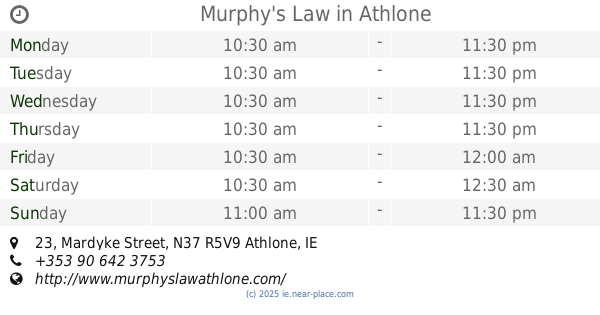
Murphy's Law
23 Mardyke Street, Athlone
Bar
read more
915 m
Flannery's Bar
4 Sean Costello Street, Athlone
Bar
read more
928 m
Grove bar,carryout off licence
Bellaugh, Athlone
Bar
read more
934 m
Carey's Tavern
38 Mardyke Street, Athlone
Bar
read more
978 m
The Junction Beer and Wings House
18 Sean Costello Street, Loughanaskin, Athlone
Bar
read more
1.029 km
YakiSoba Asian Street Food
Belhavel, Golden Island, Athlone
Bar
read more
1.101 km
Potters Bar Athlone
Sean Costello Street, Athlone, Ireland., Athlone
Bar
read more
1.668 km
The Olive Bar
Ballymahon Road, Athlone
Bar
read more
📑
all categories
Accounting
Administrative area level 1
Administrative area level 2
Airport
Amusement park
Aquarium
Art gallery
Atm
Bakery
Bank
Bar
Beauty salon
Bicycle store
Book store
Bowling alley
Bus station
Cafe
Campground
Car dealer
Car rental
Car repair
Car wash
Casino
Cemetery
Church
City hall
Clothing store
Colloquial area
Convenience store
Country
Courthouse
Dentist
Department store
Doctor
Electrician
Electronics store
Embassy
Establishment
Finance
Fire station
Florist
Food
Funeral home
Furniture store
Gas station
General contractor
Grocery or supermarket
Gym
Hair care
Hardware store
Health
Hindu Temple
Home goods store
Hospital
Insurance agency
Jewelry store
Laundry
Lawyer
Library
Light rail station
Liquor store
Local government office
Locality
Locksmith
Lodging
Meal delivery
Meal takeaway
Mosque
Movie rental
Movie theater
Moving company
Museum
Natural feature
Neighborhood
Night club
Painter
Park
Parking
Pet store
Pharmacy
Physiotherapist
Place of worship
Plumber
Point of interest
Police
Political
Post office
Premise
Real estate agency
Restaurant
Roofing contractor
Route
Rv park, camping
School
Shoe store
Shopping mall
Spa
Stadium
Storage
Store
Sublocality
Subpremise
Supermarket
Synagogue
Taxi stand
Train station
Transit station
Travel agency
University
Veterinary care
Zoo
sublocality level 1
↑