Food nearby Haggard Stores Ltd
Ireland
Food nearby Haggard Stores Ltd
Haggard Stores Ltd
Haggard Stores Ltd, Newtown, Garristown Irland
contacts phone
:
+353
Latitude:
53.567249
, Longitude:
-6.419804
read more
nearest Food
2.281 km
Bill Ryan Ltd
The Green, Garristown
Food
read more
2.393 km
Bounce World
Garristown
Food
read more
2.576 km
Foleys Precision Farming
Newtown, Garristown
Food
read more
3.997 km
Largo Foods
Kilbrew, Ashbourne
Food
read more
4.038 km
Barry's Bakery
Stonelodge, Ballymadun, Garristown
Food
read more
4.108 km
Hammondtown Farm
Hammondtown Farm, Hammondtown, Ashbourne
Food
read more
4.748 km
Catering Supreme
Sutherland, Ratoath
Food
read more
4.973 km
Mcguinness Marquees
Tankardstown, Clonalvy
Food
read more
5.126 km
Boyne Valley Meats
Unnamed Rd, Co.
Food
read more
5.899 km
Caterzone Limited
Ashbourne Business Centre, Ballybin Road, Ashbourne
Food
read more
6.423 km
Nicholas Lynch Ltd
Unit 5, Ashbourne Retail Park, 13 Ballybin Road, Ashbourne
Food
read more
6.947 km
Pitchcare Ireland
West Curragh, Naul
Food
read more
11.105 km
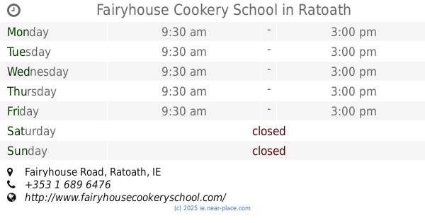
Fairyhouse Cookery School
Fairyhouse Road, Ratoath
Food
read more
11.476 km
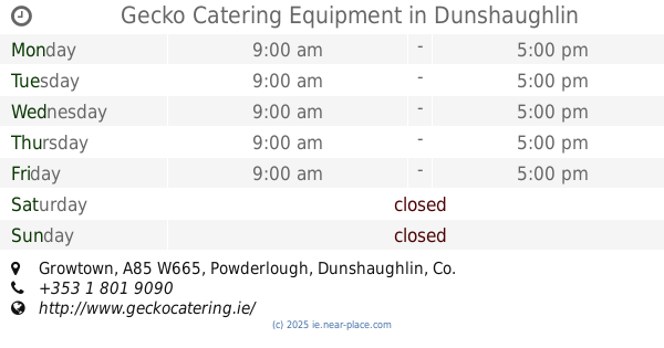
Gecko Catering Equipment
Growtown, A85 W665, Dunshaughlin
Food
read more
12.574 km
Rabbite catering
Unnamed Road Co.
Food
read more
14.466 km
Oceanstone Ltd
Jordanstown
Food
read more
16.103 km
K&K Packs Ltd
Broghan
Food
read more
16.618 km
Boyne Valley Seafoods
Unit 11A Southgate Shopping Centre, Dublin Road,, Drogheda
Food
read more
17.028 km
Magic Slush
Unit 7, Turvey Business Centre, Turvey, Donabate
Food
read more
17.066 km
Irritec Limited
Unit 22, Turvey Business Centre, Turvey Road, Donabate
Food
read more
17.286 km
Designerwine
Castlefarm, Swords
Food
read more
17.31 km
Inland Fisheries Ireland
Swords Business Campus, Balheary Road, Swords
Food
read more
17.451 km
Rapitalia Foods Ltd
Swords Food Park,, Lissenhall, Swords
Food
read more
18.257 km
Total Produce
Swords Business Park, Greenfields, Swords
Food
read more
19.677 km
Kals Bouncies
Holywell Way, Swords
Food
read more
📑
all categories
Accounting
Administrative area level 1
Administrative area level 2
Airport
Amusement park
Aquarium
Art gallery
Atm
Bakery
Bank
Bar
Beauty salon
Bicycle store
Book store
Bowling alley
Bus station
Cafe
Campground
Car dealer
Car rental
Car repair
Car wash
Casino
Cemetery
Church
City hall
Clothing store
Colloquial area
Convenience store
Country
Courthouse
Dentist
Department store
Doctor
Electrician
Electronics store
Embassy
Establishment
Finance
Fire station
Florist
Food
Funeral home
Furniture store
Gas station
General contractor
Grocery or supermarket
Gym
Hair care
Hardware store
Health
Hindu Temple
Home goods store
Hospital
Insurance agency
Jewelry store
Laundry
Lawyer
Library
Light rail station
Liquor store
Local government office
Locality
Locksmith
Lodging
Meal delivery
Meal takeaway
Mosque
Movie rental
Movie theater
Moving company
Museum
Natural feature
Neighborhood
Night club
Painter
Park
Parking
Pet store
Pharmacy
Physiotherapist
Place of worship
Plumber
Point of interest
Police
Political
Post office
Premise
Real estate agency
Restaurant
Roofing contractor
Route
Rv park, camping
School
Shoe store
Shopping mall
Spa
Stadium
Storage
Store
Sublocality
Subpremise
Supermarket
Synagogue
Taxi stand
Train station
Transit station
Travel agency
University
Veterinary care
Zoo
sublocality level 1
↑