Gas station nearby BP
Ireland
Gas station nearby BP
BP
285 Bridge Street, Craigavon Ireland
contacts phone
:
+353
Latitude:
54.4302401
, Longitude:
-6.4305261
read more
nearest Gas station
15 m
Shell A27
285 Bridge Street, Portadown, Craigavon
Gas station
read more
26 m
Bridge Filling Station - BP/Spar
285 Bridge Street, Portadown, Craigavon
Gas station
read more
335 m
Asda Petrol
24 Eden Manor, Portadown, Craigavon
Gas station
read more
465 m
Asda Petrol Station, Car Charging Station
128 Bridge Street, Portadown, Craigavon
Gas station
read more
997 m
Seagoe Filling Station
52 Lurgan Road, Portadown, Craigavon
Gas station
read more
1.006 km
BP
52 Lurgan Road, Craigavon
Gas station
read more
1.121 km
Woodside Post Office
139 Garvaghy Road, Portadown, Craigavon
Gas station
read more
1.13 km
Star
135 Garvaghy Road, Portadown, Craigavon
Gas station
read more
1.141 km
Costcutter Service Station
139 Garvaghy Road, Portadown, Craigavon
Gas station
read more
1.628 km
Dev Oil
146 Obins Street, Portadown, Craigavon
Gas station
read more
1.828 km
Laverys Filling Station
256 Obin Street, Craigavon
Gas station
read more
1.969 km
EUROSPAR P&G
11 Brownstown Road, Craigavon
Gas station
read more
2.09 km
GO Pay @ Pump
41 Armagh Road, Portadown, Craigavon
Gas station
read more
2.152 km
Maxol A4
Craigavon
Gas station
read more
2.172 km
Texaco Loughgall Road
Craigavon
Gas station
read more
2.277 km
Maxol Service Station, Litter's
24 Dungannon Road, Portadown, Craigavon
Gas station
read more
2.297 km
Dungannon Road Filling Station
24 Dungannon Road, Portadown, Craigavon
Gas station
read more
4.365 km
Top
Dobbin Road, Portadown, Craigavon
Gas station
read more
23.395 km
Whitecross Filling Station
15 Kingsmill Road, Armagh
Gas station
read more
24.048 km
Texaco Granemore Road
Armagh
Gas station
read more
27.413 km
Emo Oil - Gregorys Service Station
109 Camlough Road, Bessbrook, Newry
Gas station
read more
27.808 km
Central filling station Camlough
32 Main Street, Newry
Gas station
read more
28.044 km
T.H.Jenkinson
3 Hanslough Road, Middletown, Armagh
Gas station
read more
40.195 km
Top Oil
Main St The Crossroads, Omeath
Gas station
read more
47.678 km
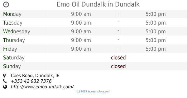
Emo Oil Dundalk
Coes Road, Dundalk
Gas station
read more
📑
all categories
Accounting
Administrative area level 1
Administrative area level 2
Airport
Amusement park
Aquarium
Art gallery
Atm
Bakery
Bank
Bar
Beauty salon
Bicycle store
Book store
Bowling alley
Bus station
Cafe
Campground
Car dealer
Car rental
Car repair
Car wash
Casino
Cemetery
Church
City hall
Clothing store
Colloquial area
Convenience store
Country
Courthouse
Dentist
Department store
Doctor
Electrician
Electronics store
Embassy
Establishment
Finance
Fire station
Florist
Food
Funeral home
Furniture store
Gas station
General contractor
Grocery or supermarket
Gym
Hair care
Hardware store
Health
Hindu Temple
Home goods store
Hospital
Insurance agency
Jewelry store
Laundry
Lawyer
Library
Light rail station
Liquor store
Local government office
Locality
Locksmith
Lodging
Meal delivery
Meal takeaway
Mosque
Movie rental
Movie theater
Moving company
Museum
Natural feature
Neighborhood
Night club
Painter
Park
Parking
Pet store
Pharmacy
Physiotherapist
Place of worship
Plumber
Point of interest
Police
Political
Post office
Premise
Real estate agency
Restaurant
Roofing contractor
Route
Rv park, camping
School
Shoe store
Shopping mall
Spa
Stadium
Storage
Store
Sublocality
Subpremise
Supermarket
Synagogue
Taxi stand
Train station
Transit station
Travel agency
University
Veterinary care
Zoo
sublocality level 1
↑