Gas station nearby Cherry Orchard Service Station
Coronavirus disease (COVID-19) Situation
confirmed cases
1734582
deaths
9491
Ireland
Gas station nearby Cherry Orchard Service Station
Cherry Orchard Service Station
Ballyfermot Road, D10 NX33, Dublin, IE Ireland
contacts phone
:
+353 1 626 6170
Latitude:
53.3438504
, Longitude:
-6.3705066
larger map & directions
read more
nearest Gas station
3 m
Applegreen
372 Ballyfermot Road, Dublin
Gas station
read more
795 m
Kennelsfort Filling Station
Dublin
Gas station
read more
798 m
Topaz
Kennelsfort Road Upper, Dublin
Gas station
read more
798 m
Circle K
Kennelsfort Road Upper, Dublin
Gas station
read more
1.104 km
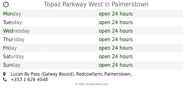
Topaz Parkway West
Lucan By Pass (Galway Bound), Palmerstown
Gas station
read more
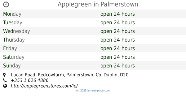
1.149 km
Applegreen
Lucan Road, Palmerstown
Gas station
read more
1.375 km
Topaz
Lucan-By-Pass (Dublin Bound), Palmerstown, Dublin 20, Co. Dublin, Palmerstown, Dublin
Gas station
read more
1.375 km
Circle K
Lucan-By-Pass (Dublin Bound), Palmerstown, Dublin 20, Co. Dublin, Palmerstown, Dublin
Gas station
read more
1.388 km
Topaz
The Hill, Chapelizod-By-Pass, Palmerstown, Dublin 20, Co. Dublin, Palmerstown, Dublin
Gas station
read more
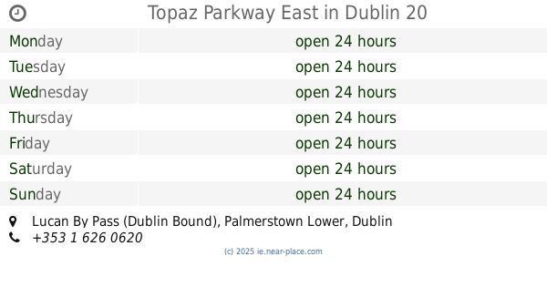
1.408 km
Topaz Parkway East
Lucan By Pass (Dublin Bound), Dublin 20
Gas station
read more
2.331 km
Top Oil
John F Kennedy Ave Unit 10, John F Kennedy Industrial Estate, Dublin
Gas station
read more
2.345 km
Top Oil
John F Kennedy Drive, Dublin
Gas station
read more
2.36 km
GO service station Gala Shop
286 Kylemore Road, Inchicore, Dublin 10
Gas station
read more
2.409 km
Esso
22 Ninth Lock Road, Dublin 22
Gas station
read more
2.409 km
Ninth Lock Service Station
22 Ninth Lock Road, Dublin
Gas station
read more
2.412 km
Spălătorie + Go Peco
Kylemore Rd Kylemore Road, Inchicore, Dublin 10
Gas station
read more
2.424 km
Applegreen
250-252 Sarsfield Road, Dublin
Gas station
read more
2.434 km
Sarsfield Service Station
Ballyfermot Road, Kilmainham, Dublin 10
Gas station
read more
2.438 km
Topaz Ninth Lock
Ninth Lock, Ninth Lock Road, Clondalkin, Dublin 22, Co. Dublin
Gas station
read more
2.505 km
Topaz
Westway Service Station, Kylemore Road, Ballyfermot, Dublin 12, Co. Dublin
Gas station
read more
2.508 km
Westway Station
Bluebell, Dublin
Gas station
read more
2.636 km
Topaz Service Station
880 Naas Road, Dublin
Gas station
read more
2.636 km
Topaz Service Station
Cranley Motor Centre, Naas Road, Dublin
Gas station
read more
2.637 km
Topaz
Naas Road, Dublin
Gas station
read more
3.037 km
Maxol Service Station, Walkinstown Avenue
Walkinstown Avenue, Walkinstown
Gas station
read more
📑
all categories
Accounting
Administrative area level 1
Administrative area level 2
Airport
Amusement park
Aquarium
Art gallery
Atm
Bakery
Bank
Bar
Beauty salon
Bicycle store
Book store
Bowling alley
Bus station
Cafe
Campground
Car dealer
Car rental
Car repair
Car wash
Casino
Cemetery
Church
City hall
Clothing store
Colloquial area
Convenience store
Country
Courthouse
Dentist
Department store
Doctor
Electrician
Electronics store
Embassy
Establishment
Finance
Fire station
Florist
Food
Funeral home
Furniture store
Gas station
General contractor
Grocery or supermarket
Gym
Hair care
Hardware store
Health
Hindu Temple
Home goods store
Hospital
Insurance agency
Jewelry store
Laundry
Lawyer
Library
Light rail station
Liquor store
Local government office
Locality
Locksmith
Lodging
Meal delivery
Meal takeaway
Mosque
Movie rental
Movie theater
Moving company
Museum
Natural feature
Neighborhood
Night club
Painter
Park
Parking
Pet store
Pharmacy
Physiotherapist
Place of worship
Plumber
Point of interest
Police
Political
Post office
Premise
Real estate agency
Restaurant
Roofing contractor
Route
Rv park, camping
School
Shoe store
Shopping mall
Spa
Stadium
Storage
Store
Sublocality
Subpremise
Supermarket
Synagogue
Taxi stand
Train station
Transit station
Travel agency
University
Veterinary care
Zoo
sublocality level 1
↑