Gas station nearby Crowes ministers cross
Ireland
Gas station nearby Crowes ministers cross
Crowes ministers cross
Unnamed Road Ireland
contacts phone
:
+353
Latitude:
52.7203023
, Longitude:
-8.8130207
read more
nearest Gas station
18 m
Maxol Service Station, Crowe's
Sixmilebridge
Gas station
read more
2.363 km
Independent
Shannon Road, Bunratty
Gas station
read more
2.386 km
Spar Express Bunratty
Old Bunratty Road, Bunratty West, Bunratty
Gas station
read more
4.293 km
Topaz
Tullyvaraga, Shannon, Co. Clare
Gas station
read more
4.523 km
TEXACO Station Shannon
Airport Road N19, 1st roundabout le, Shannon
Gas station
read more
6.598 km
Top Oil
N19, Shannon
Gas station
read more
11.244 km
O'Neill Service Station
Ballybrown, Wexford
Gas station
read more
11.325 km
Topaz Shell Ennis Road
Ennis Road, Limerick
Gas station
read more
12.966 km
Esso Spar O'Brien Kelly
Ennis Road, Limerick
Gas station
read more
12.972 km
Premier Service Station Topaz
Ennis Rd, Limerick
Gas station
read more
13.14 km
Topaz
Thomondgate, Limerick, Co. Limerick
Gas station
read more
13.726 km
Top N69
Limerick
Gas station
read more
14.311 km
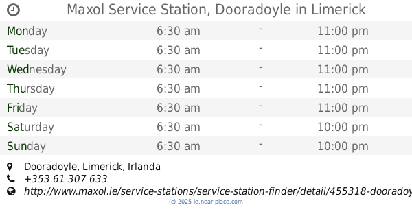
Maxol Service Station, Dooradoyle
Dooradoyle, Limerick
Gas station
read more
14.468 km
Top Oil
Doora, Ennis
Gas station
read more
14.545 km
Topaz Service Station Mughal's
Corbally Road, Cloonoughter, Limerick
Gas station
read more
15.12 km
GreatGas express 24/7
Dublin Road, Limerick
Gas station
read more
15.311 km
Emo Fuelcard Site, Sercom,
Raheen Industrial Estate, Limerick
Gas station
read more
15.342 km
Applegreen
Main Street, Patrickwell
Gas station
read more
15.377 km
Topaz R509
Limerick
Gas station
read more
15.381 km
Bennets Of Roxboro
Limerick
Gas station
read more
15.569 km
Maxol Service Station, Garryowen
Dublin Road, Garryowen
Gas station
read more
15.736 km
Clarecastle Service Station
Inis Cláir, Kildysart Road, Clarecastle
Gas station
read more
16.626 km
Top Oil
Quin Road, Ennis
Gas station
read more
17.137 km
Applegreen
Limerick Road, Ennis
Gas station
read more
18.485 km
Parkeren
2-32 Cloughleigh Road, Cloughleigh, Ennis
Gas station
read more
📑
all categories
Accounting
Administrative area level 1
Administrative area level 2
Airport
Amusement park
Aquarium
Art gallery
Atm
Bakery
Bank
Bar
Beauty salon
Bicycle store
Book store
Bowling alley
Bus station
Cafe
Campground
Car dealer
Car rental
Car repair
Car wash
Casino
Cemetery
Church
City hall
Clothing store
Colloquial area
Convenience store
Country
Courthouse
Dentist
Department store
Doctor
Electrician
Electronics store
Embassy
Establishment
Finance
Fire station
Florist
Food
Funeral home
Furniture store
Gas station
General contractor
Grocery or supermarket
Gym
Hair care
Hardware store
Health
Hindu Temple
Home goods store
Hospital
Insurance agency
Jewelry store
Laundry
Lawyer
Library
Light rail station
Liquor store
Local government office
Locality
Locksmith
Lodging
Meal delivery
Meal takeaway
Mosque
Movie rental
Movie theater
Moving company
Museum
Natural feature
Neighborhood
Night club
Painter
Park
Parking
Pet store
Pharmacy
Physiotherapist
Place of worship
Plumber
Point of interest
Police
Political
Post office
Premise
Real estate agency
Restaurant
Roofing contractor
Route
Rv park, camping
School
Shoe store
Shopping mall
Spa
Stadium
Storage
Store
Sublocality
Subpremise
Supermarket
Synagogue
Taxi stand
Train station
Transit station
Travel agency
University
Veterinary care
Zoo
sublocality level 1
↑