Gas station nearby Morris Oil
Ireland
Gas station nearby Morris Oil
Morris Oil
Waterford Road, Carrick-On-Suir Ireland
contacts phone
:
+353
Latitude:
52.3424549
, Longitude:
-7.4095207
read more
nearest Gas station
777 m
Texaco Spar Carrick-On-Suir
Carrick-On-Suir
Gas station
read more
777 m
Texaco Spar Carrick-On-Suir (Apache Pizza)
Carrick-On-Suir
Gas station
read more
879 m
Texaco Spar Carrick-On-Suir (Apache Pizza)
John Street, Carrick-On-Suir
Gas station
read more
1.463 km
Applegreen
Ballylynch, Carrick On Suir
Gas station
read more
11.655 km
Morris Oil N24
County Tipperary
Gas station
read more
12.067 km
Emo Oil- Mooncoin Stores
Main Street, Mooncoin
Gas station
read more
12.067 km
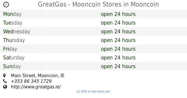
GreatGas - Mooncoin Stores
Main Street, Mooncoin
Gas station
read more
16.469 km
Swift Oil - Gala Kilmeaden Service Station
Main Street, Kilmeaden
Gas station
read more
16.471 km
Swift (East Cork Oil) Kilmeaden Services
R680, Kilmeadan, Kilmeaden
Gas station
read more
16.574 km
GreatGas - Gala Kilmeaden Service Station
Main Street, Kilmeaden
Gas station
read more
16.574 km
Gala Kilmeaden Service Station
Main Street, Kilmeaden
Gas station
read more
17.133 km
Circle K
Old Waterford Road, Clonmel
Gas station
read more
17.612 km
Strang Motors Limited
Old Waterford Road, Clonmel
Gas station
read more
18.335 km
VV-Tech LPG Ltd - Inter Auto
Coleville Road, Clonmel
Gas station
read more
19.94 km
Boherduff Service Station
Boherduff Service Station, Fethard Road
Gas station
read more
20.513 km
Top Oil
Cashel Road, Clonmel
Gas station
read more
20.571 km
Applegreen
Cleaboy Road, Waterford
Gas station
read more
21.078 km
Amber
Waterford
Gas station
read more
21.178 km
Esso R680
Waterford
Gas station
read more
21.877 km
Texaco Service Station
Jacksons Cross House, Cherrymount, Clonmel
Gas station
read more
22.172 km
Top Oil
Dock Road R711
Gas station
read more
22.177 km
Ferrybank Service Station
Ross Road, Waterford
Gas station
read more
22.546 km
Fuel station
R699
Gas station
read more
24.765 km
Waterford fast charger
Unnamed Road
Gas station
read more
26.39 km
Applegreen
Waterford Road, Tramore
Gas station
read more
📑
all categories
Accounting
Administrative area level 1
Administrative area level 2
Airport
Amusement park
Aquarium
Art gallery
Atm
Bakery
Bank
Bar
Beauty salon
Bicycle store
Book store
Bowling alley
Bus station
Cafe
Campground
Car dealer
Car rental
Car repair
Car wash
Casino
Cemetery
Church
City hall
Clothing store
Colloquial area
Convenience store
Country
Courthouse
Dentist
Department store
Doctor
Electrician
Electronics store
Embassy
Establishment
Finance
Fire station
Florist
Food
Funeral home
Furniture store
Gas station
General contractor
Grocery or supermarket
Gym
Hair care
Hardware store
Health
Hindu Temple
Home goods store
Hospital
Insurance agency
Jewelry store
Laundry
Lawyer
Library
Light rail station
Liquor store
Local government office
Locality
Locksmith
Lodging
Meal delivery
Meal takeaway
Mosque
Movie rental
Movie theater
Moving company
Museum
Natural feature
Neighborhood
Night club
Painter
Park
Parking
Pet store
Pharmacy
Physiotherapist
Place of worship
Plumber
Point of interest
Police
Political
Post office
Premise
Real estate agency
Restaurant
Roofing contractor
Route
Rv park, camping
School
Shoe store
Shopping mall
Spa
Stadium
Storage
Store
Sublocality
Subpremise
Supermarket
Synagogue
Taxi stand
Train station
Transit station
Travel agency
University
Veterinary care
Zoo
sublocality level 1
↑