Gas station nearby Topaz Ashbourne
Ireland
Gas station nearby Topaz Ashbourne
Topaz Ashbourne
Dunreagh, Ashbourne, Co. Meath, Ireland
contacts phone
:
+353
Latitude:
53.518775
, Longitude:
-6.409227
larger map & directions
read more
nearest Gas station
16 m
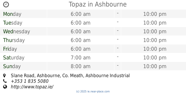
Topaz
Slane Road, Ashbourne, Co. Meath, Ashbourne
Gas station
read more
660 m
Applegreen
The Rath, Ashbourne
Gas station
read more
1.153 km
Topaz Ashbourne
Ashbourne Town Centre, Ashbourne
Gas station
read more
1.979 km
Campus Ashbourne
Ashbourne
Gas station
read more
1.986 km
Campus Garage
Milltown, Ashbourne
Gas station
read more
2.745 km
Gala/ Gulf
Baltrasna
Gas station
read more
2.753 km
Topaz
R125, Baltrasna
Gas station
read more
3.731 km
Brady's Garage Station
Main Street, Ratoath
Gas station
read more
4.187 km
Ashbourne Service Station
Derry Road - N2, Ashbourne
Gas station
read more
4.187 km
Topaz Coolfore
Ashbourne Town, Ashbourne, Co. Meath
Gas station
read more
4.358 km
Maxol
Fairyhouse Road, Rathoath, Ratoath
Gas station
read more
4.359 km
Conway's Filling Station
Ratoath
Gas station
read more
4.395 km
Top Oil
M4, Ashbourne
Gas station
read more
4.409 km
Top Oil
Lima, Kilbrew, Ashbourne
Gas station
read more
5.108 km
Great Gas Derry Road Ashbourne
The Green, Ashbourne
Gas station
read more
5.109 km
GreatGas 24/7 Ashbourne
Dublin Road, Ashbourne
Gas station
read more
5.284 km
Fairyhouse Motors
Fairyhouse Road, Ratoath
Gas station
read more
5.295 km
Topaz
Fairyhouse Road, Ratoath
Gas station
read more
5.667 km
serega servis
Masspool
Gas station
read more
10.333 km
Bracetown Service Station
R147, Clonee
Gas station
read more
12.992 km
Mulhuddart Self Service
Dublin
Gas station
read more
13.368 km
Top Oil
M1 Top Truckstop Lusk M1 Southbound Lusk
Gas station
read more
13.576 km
Alltyres
Unnamed Road, Cappoge, Dublin
Gas station
read more
14.354 km
Junction 4 Turvey
Turvey Business Park, Staffordstown, Swords
Gas station
read more
14.355 km
Topaz Blanchardstown
Main Street, Blanchardstown, Dublin
Gas station
read more
📑
all categories
Accounting
Administrative area level 1
Administrative area level 2
Airport
Amusement park
Aquarium
Art gallery
Atm
Bakery
Bank
Bar
Beauty salon
Bicycle store
Book store
Bowling alley
Bus station
Cafe
Campground
Car dealer
Car rental
Car repair
Car wash
Casino
Cemetery
Church
City hall
Clothing store
Colloquial area
Convenience store
Country
Courthouse
Dentist
Department store
Doctor
Electrician
Electronics store
Embassy
Establishment
Finance
Fire station
Florist
Food
Funeral home
Furniture store
Gas station
General contractor
Grocery or supermarket
Gym
Hair care
Hardware store
Health
Hindu Temple
Home goods store
Hospital
Insurance agency
Jewelry store
Laundry
Lawyer
Library
Light rail station
Liquor store
Local government office
Locality
Locksmith
Lodging
Meal delivery
Meal takeaway
Mosque
Movie rental
Movie theater
Moving company
Museum
Natural feature
Neighborhood
Night club
Painter
Park
Parking
Pet store
Pharmacy
Physiotherapist
Place of worship
Plumber
Point of interest
Police
Political
Post office
Premise
Real estate agency
Restaurant
Roofing contractor
Route
Rv park, camping
School
Shoe store
Shopping mall
Spa
Stadium
Storage
Store
Sublocality
Subpremise
Supermarket
Synagogue
Taxi stand
Train station
Transit station
Travel agency
University
Veterinary care
Zoo
sublocality level 1
↑