Gas station nearby Topaz
Ireland
Gas station nearby Topaz
Topaz
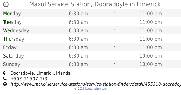
Roxboro, Limerick, V94 WFX2, Ireland
contacts phone
:
+353 61 312 033
website:
www.topaz.ie
Latitude:
52.6489013
, Longitude:
-8.6178093
larger map & directions
read more
nearest Gas station
13 m
Topaz R509
Limerick
Gas station
read more
13 m
Topaz Roxboro
Limerick
Gas station
read more
231 m
Top Oil
Roxboro Road, Limerick
Gas station
read more
250 m
Bennets Of Roxboro
Limerick
Gas station
read more
1.085 km
Inver
Ballysimon Road, Limerick
Gas station
read more
1.318 km
Inver
Punches Cross, Ballinacurra
Gas station
read more
1.661 km
Topaz N24
Limerick
Gas station
read more
1.679 km
Topaz Ballysimon Road
Ballysimon Road, Limerick
Gas station
read more
1.705 km
Stacja Ładowania
R527
Gas station
read more
1.708 km
Mount Kennett
Dock Road, Limerick
Gas station
read more
1.713 km
Topaz
Mount Kenneth, Dock Road, Limerick
Gas station
read more
1.722 km
Top N69
Limerick
Gas station
read more
1.811 km
Topaz
Dock Road, Limerick
Gas station
read more
1.863 km
GreatGas express 24/7
Dublin Road, Limerick
Gas station
read more
1.969 km
Amber Limerick
Kilmallock Road, Limerick
Gas station
read more
2.04 km
Maxol Service Station, Garryowen
Dublin Road, Garryowen
Gas station
read more
2.113 km
Caseys Londis & Topaz Service Station
Dock Road, Limerick
Gas station
read more
2.113 km
Caseys Londis Dock Road
Upper, Dock Road
Gas station
read more
2.564 km
Premier Service Station Topaz
Ennis Rd, Limerick
Gas station
read more
2.574 km
Esso Spar O'Brien Kelly
Ennis Road, Limerick
Gas station
read more
2.79 km
Topaz
Thomondgate, Limerick, Co. Limerick
Gas station
read more
2.798 km
Topaz
Dooradoyle, Limerick
Gas station
read more
2.967 km
Topaz
Dublin Road, Castletroy, Co. Limerick
Gas station
read more
3.169 km
Maxol Service Station, Dooradoyle
Dooradoyle, Limerick
Gas station
read more
3.559 km
Applegreen
Ennis Road, Limerick
Gas station
read more
📑
all categories
Accounting
Administrative area level 1
Administrative area level 2
Airport
Amusement park
Aquarium
Art gallery
Atm
Bakery
Bank
Bar
Beauty salon
Bicycle store
Book store
Bowling alley
Bus station
Cafe
Campground
Car dealer
Car rental
Car repair
Car wash
Casino
Cemetery
Church
City hall
Clothing store
Colloquial area
Convenience store
Country
Courthouse
Dentist
Department store
Doctor
Electrician
Electronics store
Embassy
Establishment
Finance
Fire station
Florist
Food
Funeral home
Furniture store
Gas station
General contractor
Grocery or supermarket
Gym
Hair care
Hardware store
Health
Hindu Temple
Home goods store
Hospital
Insurance agency
Jewelry store
Laundry
Lawyer
Library
Light rail station
Liquor store
Local government office
Locality
Locksmith
Lodging
Meal delivery
Meal takeaway
Mosque
Movie rental
Movie theater
Moving company
Museum
Natural feature
Neighborhood
Night club
Painter
Park
Parking
Pet store
Pharmacy
Physiotherapist
Place of worship
Plumber
Point of interest
Police
Political
Post office
Premise
Real estate agency
Restaurant
Roofing contractor
Route
Rv park, camping
School
Shoe store
Shopping mall
Spa
Stadium
Storage
Store
Sublocality
Subpremise
Supermarket
Synagogue
Taxi stand
Train station
Transit station
Travel agency
University
Veterinary care
Zoo
sublocality level 1
↑