Gas station nearby Topaz
Ireland
Gas station nearby Topaz
Topaz
Malahide, Co. Dublin, Irland
contacts phone
:
+353
Latitude:
53.4507238
, Longitude:
-6.1519709
larger map & directions
read more
nearest Gas station
10 m
Island Service Station
3 Main Street, Malahide
Gas station
read more
3.434 km
Applewood Mountgorry
Mountgorry
Gas station
read more
3.439 km
Costa Coffee
Mountgorry, Swords
Gas station
read more
3.44 km
Applegreen
Mountgorry, Swords
Gas station
read more
3.449 km
Applegreens
Swords Road, Malahide
Gas station
read more
3.449 km
Applegreen
Swords Road, Malahide
Gas station
read more
3.554 km
Texaco
Strand Road, Portmarnock
Gas station
read more
3.74 km
Maxol Service Station, Hearse Road
Hearse Road, Donabate
Gas station
read more
3.834 km
Applegreen
Malahide Road, Kinsealy
Gas station
read more
3.893 km
Applegreen Kinsealy
County Dublin
Gas station
read more
4.576 km
Applegreen
North Street, Swords
Gas station
read more
4.793 km
Swords Service Station
Dublin Road, Dublin
Gas station
read more
4.816 km
Circle K
Milton Fields Service Station, Dublin Road, Swords
Gas station
read more
4.816 km
Topaz
Milton Fields Service Station, Dublin Road, Swords
Gas station
read more
5.024 km
Topaz Restore Westview
Lissenhall, Swords
Gas station
read more
5.516 km
Junction 4 Turvey
Turvey Business Park, Staffordstown, Swords
Gas station
read more
6.035 km
Topaz
Clonshaugh Road, Swords, Dublin 17
Gas station
read more
6.139 km
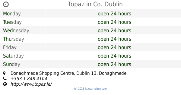
Topaz
Donaghmede Shopping Centre, Dublin 13, Co. Dublin
Gas station
read more
7.295 km
Texaco
Dublin Road, Dublin
Gas station
read more
10.669 km
Top Oil
M1 Top Truckstop Lusk M1 Southbound Lusk
Gas station
read more
11.219 km
Toms Garage
Balseskin
Gas station
read more
14.038 km
Alltyres
Unnamed Road, Cappoge, Dublin
Gas station
read more
14.412 km
Maxol
4 Mespil Road, Dublin
Gas station
read more
15.478 km
Ashtown Service Station
Navan Road, Dublin
Gas station
read more
15.899 km
Applegreen
Parnell Rd, Dublin
Gas station
read more
📑
all categories
Accounting
Administrative area level 1
Administrative area level 2
Airport
Amusement park
Aquarium
Art gallery
Atm
Bakery
Bank
Bar
Beauty salon
Bicycle store
Book store
Bowling alley
Bus station
Cafe
Campground
Car dealer
Car rental
Car repair
Car wash
Casino
Cemetery
Church
City hall
Clothing store
Colloquial area
Convenience store
Country
Courthouse
Dentist
Department store
Doctor
Electrician
Electronics store
Embassy
Establishment
Finance
Fire station
Florist
Food
Funeral home
Furniture store
Gas station
General contractor
Grocery or supermarket
Gym
Hair care
Hardware store
Health
Hindu Temple
Home goods store
Hospital
Insurance agency
Jewelry store
Laundry
Lawyer
Library
Light rail station
Liquor store
Local government office
Locality
Locksmith
Lodging
Meal delivery
Meal takeaway
Mosque
Movie rental
Movie theater
Moving company
Museum
Natural feature
Neighborhood
Night club
Painter
Park
Parking
Pet store
Pharmacy
Physiotherapist
Place of worship
Plumber
Point of interest
Police
Political
Post office
Premise
Real estate agency
Restaurant
Roofing contractor
Route
Rv park, camping
School
Shoe store
Shopping mall
Spa
Stadium
Storage
Store
Sublocality
Subpremise
Supermarket
Synagogue
Taxi stand
Train station
Transit station
Travel agency
University
Veterinary care
Zoo
sublocality level 1
↑