Health nearby Mullingar Primary Care Centre
Ireland
Health nearby Mullingar Primary Care Centre
Mullingar Primary Care Centre
Commons, Mullingar Irland
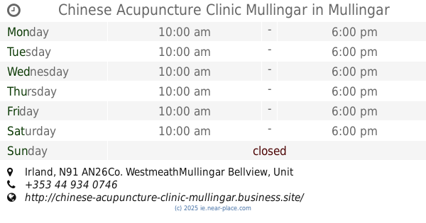
contacts phone
:
+353
Latitude:
53.532136
, Longitude:
-7.3451382
read more
nearest Health
334 m
LighterLife Counsellor - Katrina Tansley
Harbour Street, Mullingar
Health
read more
540 m
Saint Mary's Care Centre
Saint Mary's Hospital, Longford Road, Mullingar
Health
read more
615 m
Aine Connaire Counselling and Psychotherapy
Unit 17, The Enterprise Centre, Bishop's Gate Street, Mullingar
Health
read more
636 m
Ancient Wisdom - Chinese Medical Clinics
Bishop's Gate Street, Mullingar
Health
read more
695 m
Chinese Acupuncture Clinic Mullingar
MullingarUnit 5, Castle street
Health
read more
737 m
Therapeutic Treats
38 Pearse Street, Mullingar
Health
read more
830 m
121 Safety Ltd.
Coole, Mullingar
Health
read more
851 m
Medilink mullingar base
Robinstown (Levinge), Mullingar
Health
read more
856 m
The Healthy Weigh
The Healthy Weigh, Midlands Mental Health Clinic,, Permanent House,, Austin Friars Street, mullingar
Health
read more
861 m
Midlands Mental Health Clinic - Mullingar
Transformative College, Austin Friars Street, Mullingar
Health
read more
866 m
Lice Clinics of Ireland - Westmeath Longford Offaly
6 St John's Terrace, Blackhall Street, Commons, Mullingar
Health
read more
890 m
Motivation Weight Management Clinic
3 Columb Drive, Mullingar
Health
read more
891 m
Irish Karate Kyokushinkai
Parish Community Centre, Bishop's Gate Street, Mullingar
Health
read more
912 m
Fit with Ann
46 Austin Friars Street, Bellview, Mullingar
Health
read more
1.029 km
Martial Arts Mullingar
Shogun.ie West Meath, Austin Friars Street, Mullingar
Health
read more
📑
all categories
Accounting
Administrative area level 1
Administrative area level 2
Airport
Amusement park
Aquarium
Art gallery
Atm
Bakery
Bank
Bar
Beauty salon
Bicycle store
Book store
Bowling alley
Bus station
Cafe
Campground
Car dealer
Car rental
Car repair
Car wash
Casino
Cemetery
Church
City hall
Clothing store
Colloquial area
Convenience store
Country
Courthouse
Dentist
Department store
Doctor
Electrician
Electronics store
Embassy
Establishment
Finance
Fire station
Florist
Food
Funeral home
Furniture store
Gas station
General contractor
Grocery or supermarket
Gym
Hair care
Hardware store
Health
Hindu Temple
Home goods store
Hospital
Insurance agency
Jewelry store
Laundry
Lawyer
Library
Light rail station
Liquor store
Local government office
Locality
Locksmith
Lodging
Meal delivery
Meal takeaway
Mosque
Movie rental
Movie theater
Moving company
Museum
Natural feature
Neighborhood
Night club
Painter
Park
Parking
Pet store
Pharmacy
Physiotherapist
Place of worship
Plumber
Point of interest
Police
Political
Post office
Premise
Real estate agency
Restaurant
Roofing contractor
Route
Rv park, camping
School
Shoe store
Shopping mall
Spa
Stadium
Storage
Store
Sublocality
Subpremise
Supermarket
Synagogue
Taxi stand
Train station
Transit station
Travel agency
University
Veterinary care
Zoo
sublocality level 1
↑