Lodging nearby Gateway
Ireland
Lodging nearby Gateway
Gateway
Unnamed Road, Silloge Irlanda
contacts phone
:
+353
Latitude:
53.7656035
, Longitude:
-6.3926811
read more
nearest Lodging
3.386 km
Broadleaf Manor
Allen Wood, Nursery Cross
Lodging
read more
3.632 km
Downey furniture
R168
Lodging
read more
4.046 km
Listoke House
Whitethorn House, Ballymakenny Road, Listoke, Drogheda
Lodging
read more
4.668 km
An Dun Orga
An Dun Orga, Drogheda
Lodging
read more
4.963 km
Windsor Lodge B&B Hotel
1 The, North Road, Drogheda
Lodging
read more
4.963 km
WINDSOR LODGE
1 The, North Road, Drogheda
Lodging
read more
4.963 km
Windsor Lodge Guest House
1 The, North Road, Drogheda
Lodging
read more
4.963 km
Windsor Lodge B&B
1 The, North Road, Drogheda
Lodging
read more
5.13 km
Mcardle green
113 Moneymore, Drogheda
Lodging
read more
5.454 km
Townleyhall Appartments
Unnamed Road Slane, Battle of the Boyne Visitor Centre
Lodging
read more
5.454 km
Townley Hall Apartments
Townleyhall, Drogheda
Lodging
read more
5.582 km
Jomi B&B
6 Flaxmill Court, Drogheda
Lodging
read more
5.824 km
The Old Cottage
Newtownstalaban
Lodging
read more
6.325 km
CASTLE GANDOLFO
4, The Cornstore, Constitution Hill, East Drogheda, Drogheda
Lodging
read more
8.079 km
Boyne Valley Hotel
Boyne Valley Hotel Lodge, Dublin Road, Drogheda
Lodging
read more
8.417 km
Hawthorn Cottage
9 Drogheda Road
Lodging
read more
9.765 km
Port Oriel Caravan Park
Ganderstown, Clogherhead
Lodging
read more
11.122 km
Duleek Guesthouse
Station Road, Duleek
Lodging
read more
12.008 km
Castleview House B&B
Saint Erc's Terrace, Slane
Lodging
read more
12.167 km
Mc Donaghs Caravan Park Bettystown
Triton Road
Lodging
read more
13.912 km
Beach Park Home
Laytown
Lodging
read more
13.927 km
Tara Guest House
Laytown Road, Laytown
Lodging
read more
14.236 km
Castle View B&B
Castle Court, Dublin Road, Castlebellingham
Lodging
read more
14.608 km
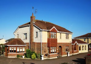
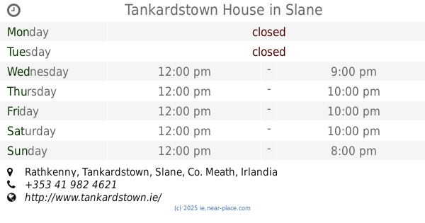
Tankardstown House
Rathkenny, Slane
Lodging
read more
16.28 km
James' House
Stamullin
Lodging
read more
📑
all categories
Accounting
Administrative area level 1
Administrative area level 2
Airport
Amusement park
Aquarium
Art gallery
Atm
Bakery
Bank
Bar
Beauty salon
Bicycle store
Book store
Bowling alley
Bus station
Cafe
Campground
Car dealer
Car rental
Car repair
Car wash
Casino
Cemetery
Church
City hall
Clothing store
Colloquial area
Convenience store
Country
Courthouse
Dentist
Department store
Doctor
Electrician
Electronics store
Embassy
Establishment
Finance
Fire station
Florist
Food
Funeral home
Furniture store
Gas station
General contractor
Grocery or supermarket
Gym
Hair care
Hardware store
Health
Hindu Temple
Home goods store
Hospital
Insurance agency
Jewelry store
Laundry
Lawyer
Library
Light rail station
Liquor store
Local government office
Locality
Locksmith
Lodging
Meal delivery
Meal takeaway
Mosque
Movie rental
Movie theater
Moving company
Museum
Natural feature
Neighborhood
Night club
Painter
Park
Parking
Pet store
Pharmacy
Physiotherapist
Place of worship
Plumber
Point of interest
Police
Political
Post office
Premise
Real estate agency
Restaurant
Roofing contractor
Route
Rv park, camping
School
Shoe store
Shopping mall
Spa
Stadium
Storage
Store
Sublocality
Subpremise
Supermarket
Synagogue
Taxi stand
Train station
Transit station
Travel agency
University
Veterinary care
Zoo
sublocality level 1
↑