Lodging nearby Lougher Farm B&B
Ireland
Lodging nearby Lougher Farm B&B
Lougher Farm B&B
Lougher, Duleek Ireland
contacts phone
:
+353
Latitude:
53.6767629
, Longitude:
-6.4795491
read more
nearest Lodging
1.809 km
Rossnaree House
Slane Parochial Hall, 3 Chapel Street, Slane
Lodging
read more
3.126 km
Newgrange Lodge
Staleen Road, Donore
Lodging
read more
3.482 km
Weston House
R150, Duleek
Lodging
read more
3.699 km
Netterville Manor
Dowth
Lodging
read more
4.183 km
Duleek Guesthouse
Station Road, Duleek
Lodging
read more
4.304 km
Hawthorn Cottage
9 Drogheda Road
Lodging
read more
4.487 km
The Old Dispensary Holiday Home
2 Staleen Road
Lodging
read more
4.617 km
Mc Govern Family Res
Flemingstown
Lodging
read more
4.929 km
Newtown Lodge
14 R150, Duleek
Lodging
read more
5.405 km
The Cherith Lea House Experience
Gaskinstown Lane, The Deenes, Duleek
Lodging
read more
5.424 km
Cosy Slane Accomodation
Ledwidge Hall
Lodging
read more
5.481 km
San Giovanni House B&B
Dublin Road, Slane
Lodging
read more
5.552 km
B&B C.U. In Slane
Chapel Street
Lodging
read more
5.561 km
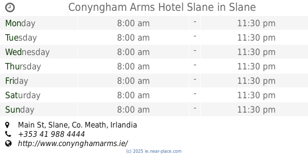
Conyngham Arms Hotel Slane
Main Street, Slane
Lodging
read more
5.561 km
Conyngham Arms Hotel Slane
Main St, Slane
Lodging
read more
5.581 km
The Three Bears Cottage
Unnamed Road, Co.
Lodging
read more
5.644 km
Boyne House Slane
Chapel Street, Slane
Lodging
read more
5.83 km
Sheephouse Country Courtyard
Sheephouse
Lodging
read more
5.867 km
The Fǻilte B&B
Castle Hill, Slane
Lodging
read more
5.874 km
The Failte B&B
Main Street, Slane
Lodging
read more
5.894 km
Castleview House B&B
Saint Erc's Terrace, Slane
Lodging
read more
8.626 km
The Saddle Room
Riverstown
Lodging
read more
9.78 km
CASTLE GANDOLFO
4, The Cornstore, Constitution Hill, East Drogheda, Drogheda
Lodging
read more
10.799 km
Boyne Valley Hotel
Boyne Valley Hotel Lodge, Dublin Road, Drogheda
Lodging
read more
11.208 km
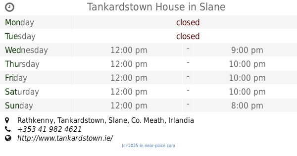
Tankardstown House
Rathkenny, Slane
Lodging
read more
📑
all categories
Accounting
Administrative area level 1
Administrative area level 2
Airport
Amusement park
Aquarium
Art gallery
Atm
Bakery
Bank
Bar
Beauty salon
Bicycle store
Book store
Bowling alley
Bus station
Cafe
Campground
Car dealer
Car rental
Car repair
Car wash
Casino
Cemetery
Church
City hall
Clothing store
Colloquial area
Convenience store
Country
Courthouse
Dentist
Department store
Doctor
Electrician
Electronics store
Embassy
Establishment
Finance
Fire station
Florist
Food
Funeral home
Furniture store
Gas station
General contractor
Grocery or supermarket
Gym
Hair care
Hardware store
Health
Hindu Temple
Home goods store
Hospital
Insurance agency
Jewelry store
Laundry
Lawyer
Library
Light rail station
Liquor store
Local government office
Locality
Locksmith
Lodging
Meal delivery
Meal takeaway
Mosque
Movie rental
Movie theater
Moving company
Museum
Natural feature
Neighborhood
Night club
Painter
Park
Parking
Pet store
Pharmacy
Physiotherapist
Place of worship
Plumber
Point of interest
Police
Political
Post office
Premise
Real estate agency
Restaurant
Roofing contractor
Route
Rv park, camping
School
Shoe store
Shopping mall
Spa
Stadium
Storage
Store
Sublocality
Subpremise
Supermarket
Synagogue
Taxi stand
Train station
Transit station
Travel agency
University
Veterinary care
Zoo
sublocality level 1
↑