Lodging nearby Major's Cove
Ireland
Lodging nearby Major's Cove
Major's Cove
Corporation Murragh, Co. Wicklow, Irland
contacts phone
:
+353
Latitude:
52.9896399
, Longitude:
-6.046069
larger map & directions
read more
nearest Lodging
818 m
River Lodge Bed & Breakfast
Church Hill, Wicklow
Lodging
read more
948 m
Halpin's Town House Bed & Breakfast
1-3 Bachelor's Walk, Wicklow
Lodging
read more
997 m
The Grand Hotel
Abbey Street, Wicklow
Lodging
read more
1.305 km
KILMANTIN HILL
10 Kilmantin Hill, Wicklow
Lodging
read more
1.568 km
Luxury Lodge Tinakilly
Luxury Lodge Tinakilly, Rathnew
Lodging
read more
1.57 km
Tinakilly Country House
Tinakilly, Rathnew
Lodging
read more
1.576 km
Hilltop Seaview Apartment
12, Keatingstown, Wicklow
Lodging
read more
1.706 km
Knockrobin Glamping
Rathnew, Wicklow
Lodging
read more
2.17 km
Drom Ard B&B
Lower Ballynerrin, Wicklow
Lodging
read more
2.395 km
Glen Na Smole B&B
Marlton Road, Wicklow
Lodging
read more
2.399 km
Glen Na Smole Bed & Breakfast
Ireland
Lodging
read more
2.4 km
Glen Na Smole
Ashtown Lane, Wicklow
Lodging
read more
2.4 km
Glen Na Smole
Ashtown Lane, Marlton Road, Wicklow
Lodging
read more
3.048 km
Dunbur Lodge
Dunbur Road, Wicklow
Lodging
read more
3.323 km
Rospark B&B
Rospark, Dunbur lower, Wicklow Town
Lodging
read more
4.028 km
Ashford Self Catering Holiday Homes
Rossana Farm, Ashford
Lodging
read more
4.122 km
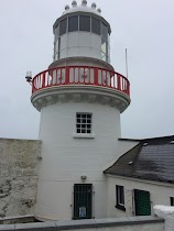
Wicklow Head Lighthouse
County Wicklow
Lodging
read more
4.66 km
Mount Usher View B&B
Ashford
Lodging
read more
4.67 km
Silverstrand
Dunbur Upper
Lodging
read more
4.781 km
Devlin's cottage
Ashford
Lodging
read more
4.781 km
Woodview Ashford
Ashford
Lodging
read more
5.091 km
Pallas Lodge B&B
Ireland
Lodging
read more
5.091 km
Pallas Lodge B&B
Mont Alto, Ashford
Lodging
read more
5.635 km
Rathmore Country House and Holiday Village
Rathmore, Ashford
Lodging
read more
5.742 km
Carriglen B&B
Ballinahinch, Ashford
Lodging
read more
📑
all categories
Accounting
Administrative area level 1
Administrative area level 2
Airport
Amusement park
Aquarium
Art gallery
Atm
Bakery
Bank
Bar
Beauty salon
Bicycle store
Book store
Bowling alley
Bus station
Cafe
Campground
Car dealer
Car rental
Car repair
Car wash
Casino
Cemetery
Church
City hall
Clothing store
Colloquial area
Convenience store
Country
Courthouse
Dentist
Department store
Doctor
Electrician
Electronics store
Embassy
Establishment
Finance
Fire station
Florist
Food
Funeral home
Furniture store
Gas station
General contractor
Grocery or supermarket
Gym
Hair care
Hardware store
Health
Hindu Temple
Home goods store
Hospital
Insurance agency
Jewelry store
Laundry
Lawyer
Library
Light rail station
Liquor store
Local government office
Locality
Locksmith
Lodging
Meal delivery
Meal takeaway
Mosque
Movie rental
Movie theater
Moving company
Museum
Natural feature
Neighborhood
Night club
Painter
Park
Parking
Pet store
Pharmacy
Physiotherapist
Place of worship
Plumber
Point of interest
Police
Political
Post office
Premise
Real estate agency
Restaurant
Roofing contractor
Route
Rv park, camping
School
Shoe store
Shopping mall
Spa
Stadium
Storage
Store
Sublocality
Subpremise
Supermarket
Synagogue
Taxi stand
Train station
Transit station
Travel agency
University
Veterinary care
Zoo
sublocality level 1
↑