Lodging nearby The Granary
Ireland
Lodging nearby The Granary
The Granary
Julianstown Ireland
contacts phone
:
+353
Latitude:
53.8121483
, Longitude:
-6.6851408
read more
nearest Lodging
2.865 km
Curtis Pad
Possextown
Lodging
read more
4.726 km
Quoinstone and Arch Court Self Catering
Slane Road, Navan
Lodging
read more
6.466 km
Mandistown Farmhouse
Mandistown, Drumconrath
Lodging
read more
7.391 km
Darley Grange
parliament cross, Balrath, Drumconrath
Lodging
read more
8.477 km
Drakestown
L1264, Kilpatrick
Lodging
read more
9.3 km
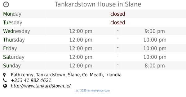
Tankardstown House
Rathkenny, Slane
Lodging
read more
10.914 km
Grangeclare Paddocks B&B
Oristown
Lodging
read more
10.942 km
Woodview B&B
Ardee Co.Louth 041 6853672, Rahanna
Lodging
read more
12.719 km
Cabra Castle Hotel
Kingscourt
Lodging
read more
12.837 km
Teach T-Mac
Dublin Road, Lisanisky, Kingscourt
Lodging
read more
12.944 km
Dun A Ri House Hotel/McMahons Cafe Bar
Cavan
Lodging
read more
13.964 km
Broomfield House Bed and Breakfast
Broomfield, Collon
Lodging
read more
14.177 km
The Old Mill B&B Slane
The Old Mill, Higginstown, Slane
Lodging
read more
14.446 km
Castleview House B&B
Saint Erc's Terrace, Slane
Lodging
read more
14.45 km
The Fǻilte B&B
Castle Hill, Slane
Lodging
read more
14.451 km
The Failte B&B
Main Street, Slane
Lodging
read more
14.753 km
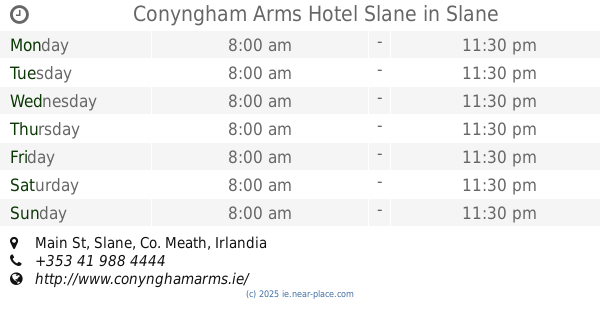
Conyngham Arms Hotel Slane
Main St, Slane
Lodging
read more
14.826 km
San Giovanni House B&B
Dublin Road, Slane
Lodging
read more
15.018 km
Louth Arms B&B
Tallanstown, Co.
Lodging
read more
15.073 km
Tallanstown House
2 Glyde Road, Rathbrist, Tallanstown
Lodging
read more
15.442 km
Janetta
2 Headford Road, Kells
Lodging
read more
15.482 km
headford Park
11 Headfort Park, Kells
Lodging
read more
16.479 km
Birchwood B&B
Balrath Road, Kells
Lodging
read more
18.574 km
Birchwood B&B
Balrath Rd, Barfordstown Balrath kells, Kells
Lodging
read more
18.593 km
Birchwood B&B
Birvhwood B&B, Barfordstown, Kells
Lodging
read more
📑
all categories
Accounting
Administrative area level 1
Administrative area level 2
Airport
Amusement park
Aquarium
Art gallery
Atm
Bakery
Bank
Bar
Beauty salon
Bicycle store
Book store
Bowling alley
Bus station
Cafe
Campground
Car dealer
Car rental
Car repair
Car wash
Casino
Cemetery
Church
City hall
Clothing store
Colloquial area
Convenience store
Country
Courthouse
Dentist
Department store
Doctor
Electrician
Electronics store
Embassy
Establishment
Finance
Fire station
Florist
Food
Funeral home
Furniture store
Gas station
General contractor
Grocery or supermarket
Gym
Hair care
Hardware store
Health
Hindu Temple
Home goods store
Hospital
Insurance agency
Jewelry store
Laundry
Lawyer
Library
Light rail station
Liquor store
Local government office
Locality
Locksmith
Lodging
Meal delivery
Meal takeaway
Mosque
Movie rental
Movie theater
Moving company
Museum
Natural feature
Neighborhood
Night club
Painter
Park
Parking
Pet store
Pharmacy
Physiotherapist
Place of worship
Plumber
Point of interest
Police
Political
Post office
Premise
Real estate agency
Restaurant
Roofing contractor
Route
Rv park, camping
School
Shoe store
Shopping mall
Spa
Stadium
Storage
Store
Sublocality
Subpremise
Supermarket
Synagogue
Taxi stand
Train station
Transit station
Travel agency
University
Veterinary care
Zoo
sublocality level 1
↑