Museum nearby Church of Ireland
Ireland
Museum nearby Church of Ireland
Church of Ireland
R493 Irlandia
contacts phone
:
+353
Latitude:
52.9737788
, Longitude:
-8.2407123
read more
nearest Museum
779 m
Tullaun Castle
Carrigagown North
Museum
read more
1.892 km
Annagh Castle
Annagh
Museum
read more
12.315 km
Nenagh Heritage Centre
Nenagh North, Nenagh
Museum
read more
13.573 km
The Woodford Heritage Centre
Woodford
Museum
read more
22.459 km
Rathcabbin Tertiary Chapel
Graigue
Museum
read more
22.834 km
Brian Boru Heritage Centre
Lough House, The Bridge, Killaloe
Museum
read more
24.193 km
St Oran's (St Odhran) Holy Well
Oatfield
Museum
read more
25.629 km
Irish Game and Country Fair
Birr Castle, Castle Street, Birr
Museum
read more
33.072 km
Clonfert Museum
Barrack Street, Loughrea
Museum
read more
33.139 km
Monaincha Abbey Crannog
Gurteen
Museum
read more
36.314 km
Tourist Office
Raghra
Museum
read more
36.924 km
Battle of Aughrim Interpretative Centre
Aughrim
Museum
read more
37.05 km
Bullaun National School
Gortcam
Museum
read more
38.945 km
CastleRuins - Casteltroy
Castletroy
Museum
read more
40.882 km
Kiltartan Gregory Museum & Millennium Park
Kiltartan Cross, Kiltartan, Gort
Museum
read more
42.433 km
St Patrick's Well Statue
22-44 Well Field, Limerick
Museum
read more
42.5 km
Lock Quay Bridge
Unnamed Road
Museum
read more
43.147 km
Clonmacnoise House
Clonmacnoise
Museum
read more
43.147 km
Theb Nun's Church, Clonmacnois
Clonmacnoise
Museum
read more
43.726 km
Frank McCourt Museum
Hartstonge Street, Limerick
Museum
read more
44.022 km
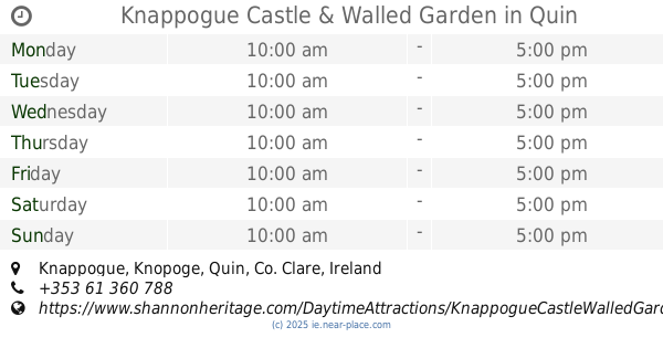
Knappogue Castle & Walled Garden
Knappogue, Quin
Museum
read more
48.823 km
Ирландия
Galway
Museum
read more
51.745 km
Clare Museum
Lifford, Ennis
Museum
read more
56.294 km
LiosLough
7A Lios Na Cri, Oranmore
Museum
read more
61.758 km
Lackagh Museum & Heritage Centre
Lackagh, Carnoneen
Museum
read more
📑
all categories
Accounting
Administrative area level 1
Administrative area level 2
Airport
Amusement park
Aquarium
Art gallery
Atm
Bakery
Bank
Bar
Beauty salon
Bicycle store
Book store
Bowling alley
Bus station
Cafe
Campground
Car dealer
Car rental
Car repair
Car wash
Casino
Cemetery
Church
City hall
Clothing store
Colloquial area
Convenience store
Country
Courthouse
Dentist
Department store
Doctor
Electrician
Electronics store
Embassy
Establishment
Finance
Fire station
Florist
Food
Funeral home
Furniture store
Gas station
General contractor
Grocery or supermarket
Gym
Hair care
Hardware store
Health
Hindu Temple
Home goods store
Hospital
Insurance agency
Jewelry store
Laundry
Lawyer
Library
Light rail station
Liquor store
Local government office
Locality
Locksmith
Lodging
Meal delivery
Meal takeaway
Mosque
Movie rental
Movie theater
Moving company
Museum
Natural feature
Neighborhood
Night club
Painter
Park
Parking
Pet store
Pharmacy
Physiotherapist
Place of worship
Plumber
Point of interest
Police
Political
Post office
Premise
Real estate agency
Restaurant
Roofing contractor
Route
Rv park, camping
School
Shoe store
Shopping mall
Spa
Stadium
Storage
Store
Sublocality
Subpremise
Supermarket
Synagogue
Taxi stand
Train station
Transit station
Travel agency
University
Veterinary care
Zoo
sublocality level 1
↑