Night club nearby SG1 Club
Ireland
Night club nearby SG1 Club
SG1 Club
Ashe Quay, Rath-Healy, Fermoy Irland
contacts phone
:
+353
Latitude:
52.1383842
, Longitude:
-8.2765164
read more
nearest Night club
23 m
SGI Club
Ashe Quay, Rath-Healy, Fermoy
Night club
read more
74 m
Synergy Stocktaking
Apt 2, Waterside Apts,, Ashe Quay, Fermoy
Night club
read more
15.227 km
Island View House
The View, Glengarriff
Night club
read more
23.418 km
Beatz Disco
R616, Ballinvriskig
Night club
read more
23.418 km
upper Glanmire Beatz Disco
R616, Ballinvriskig
Night club
read more
25.733 km
Lynn's Place
Crawford Woods, Poulacurry South
Night club
read more
29.747 km
Savoy Club and Venue
107-108 Saint Patrick's Street, Cork
Night club
read more
29.781 km
Cyprus Avenue
Caroline Street, Cork
Night club
read more
29.878 km
Dali
13 Carey's Lane, Centre, Cork
Night club
read more
30.021 km
Voodoo Rooms
74 Oliver Plunkett Street, Cork
Night club
read more
30.025 km
Parken Cork
1 Market Lane, Centre, Cork
Night club
read more
30.032 km
The Roxy Night Club
3 South Main Street, Cork
Night club
read more
30.124 km
The Bowery
21 Tuckey Street, Cork
Night club
read more
30.127 km
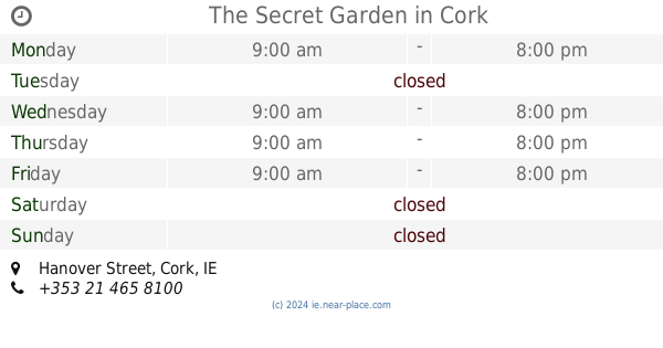
The Secret Garden
Hanover Street, Cork
Night club
read more
30.131 km
Havana Browns
5 Hanover Street, Cork
Night club
read more
30.14 km
TipTop
21 Tuckey Street, Cork
Night club
read more
30.164 km
CUBE
18 Hanover St, Centre, Cork, T12 P2HY Hanover Street, Centre, Cork
Night club
read more
35.27 km
Jack Lynch Business Lounge
Kinsale Road, Cork
Night club
read more
35.273 km
Aspire Lounge
Cork airport, Kinsale Road, Cork
Night club
read more
37.454 km
Charleville Park Hotel
Limerick Road, Charleville
Night club
Gym
Cafe
Bar
Health
Lodging
Food
Point of interest
Establishment
read more
40.035 km
Lee Valley Night Club
Mullaghroe
Night club
read more
45.076 km
Waves Nightclub & Murphy's Bar
Davitts Quay, Dungarvan
Night club
read more
45.389 km
Minnies & Club Creation
Strandside Roundabout, Abbeyside, Dungarvan
Night club
read more
46.815 km
Knockavilla Cemetry
Knockavilla, Knockgorm
Night club
read more
53.749 km
The Park
Cloghcarrigeen East
Night club
read more
📑
all categories
Accounting
Administrative area level 1
Administrative area level 2
Airport
Amusement park
Aquarium
Art gallery
Atm
Bakery
Bank
Bar
Beauty salon
Bicycle store
Book store
Bowling alley
Bus station
Cafe
Campground
Car dealer
Car rental
Car repair
Car wash
Casino
Cemetery
Church
City hall
Clothing store
Colloquial area
Convenience store
Country
Courthouse
Dentist
Department store
Doctor
Electrician
Electronics store
Embassy
Establishment
Finance
Fire station
Florist
Food
Funeral home
Furniture store
Gas station
General contractor
Grocery or supermarket
Gym
Hair care
Hardware store
Health
Hindu Temple
Home goods store
Hospital
Insurance agency
Jewelry store
Laundry
Lawyer
Library
Light rail station
Liquor store
Local government office
Locality
Locksmith
Lodging
Meal delivery
Meal takeaway
Mosque
Movie rental
Movie theater
Moving company
Museum
Natural feature
Neighborhood
Night club
Painter
Park
Parking
Pet store
Pharmacy
Physiotherapist
Place of worship
Plumber
Point of interest
Police
Political
Post office
Premise
Real estate agency
Restaurant
Roofing contractor
Route
Rv park, camping
School
Shoe store
Shopping mall
Spa
Stadium
Storage
Store
Sublocality
Subpremise
Supermarket
Synagogue
Taxi stand
Train station
Transit station
Travel agency
University
Veterinary care
Zoo
sublocality level 1
↑