Park nearby Ballynafagh Lake
Coronavirus disease (COVID-19) Situation
confirmed cases
1734582
deaths
9491
Ireland
Park nearby Ballynafagh Lake
Ballynafagh Lake
Ballynafagh Irlandia
contacts phone
:
+353
Latitude:
53.3040467
, Longitude:
-6.785739
read more
nearest Park
3.851 km
Somerton Stud
R409, Naas
Park
read more
4.645 km
Coolcarrigan House & Gardens
Coill Dubh, Naas
Park
read more
7.484 km
Woodview Plants
Ballyteague, Kilmeague, Naas
Park
read more
7.524 km
Garden Direct
Ballyteague, Kilmeague, Naas
Park
read more
7.551 km
Dunfierth Wetland & Eco Park
Cloona
Park
read more
8.726 km
Drehid Landfill
Killinagh Upper, Carbury
Park
read more
10.75 km
Volvo Roundabout
Millenium, Millennium Park
Park
read more
11.558 km
An Choill
Cloona
Park
read more
11.631 km
Naas Park
27 Kerdiff Close, Naas
Park
read more
11.71 km
Monread Park
15 Oldtown Close, Naas
Park
read more
12.348 km
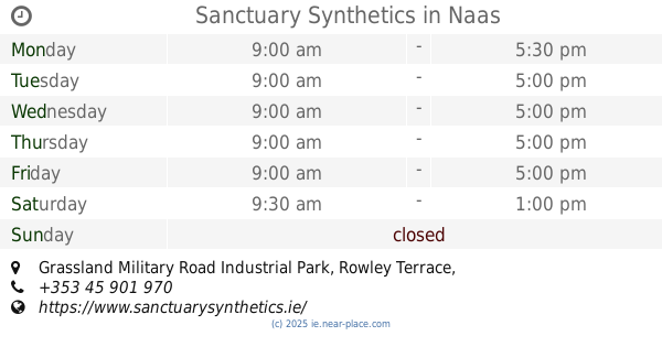
Sanctuary Synthetics
Grassland Military Road Industrial Park, Rowley Terrace, Newbridge Road, W91 PP93, Naas
Park
read more
12.448 km
The Hidbin Limited
Beaufort, Sallins Road, Naas
Park
read more
12.722 km
Common West Playground
Ireland
Park
read more
12.722 km
Common West Playground
Irlanda
Park
read more
12.722 km
Common West Playground
Irland
Park
read more
12.92 km
Fair Green
6 Railway Terrace, Naas
Park
read more
12.96 km
K & M Nurseries Ltd
Ballyhagan
Park
read more
13.207 km
Naas Old Railway Walk
27 Lakelands Naas East Naas Co. Kildare, W91 DR6Y Lakelands, Naas East, Naas
Park
read more
13.6 km
Rose lawn Stud
Roselawn House, Posseckstown, Celbridge
Park
read more
14.032 km
Ryston Sports and Social Club
Ireland
Park
read more
14.979 km
Bicentenary Garden
Maynooth
Park
read more
15.105 km
St. Joseph’s Square
Maynooth
Park
read more
15.119 km
Kilgar House Gardens
Ferrans
Park
read more
16.013 km
Killinthomas Wood
2, Woodlands, Rathangan
Park
read more
19.045 km
garden4veg.com
Knavinstown, Kildare
Park
read more
📑
all categories
Accounting
Administrative area level 1
Administrative area level 2
Airport
Amusement park
Aquarium
Art gallery
Atm
Bakery
Bank
Bar
Beauty salon
Bicycle store
Book store
Bowling alley
Bus station
Cafe
Campground
Car dealer
Car rental
Car repair
Car wash
Casino
Cemetery
Church
City hall
Clothing store
Colloquial area
Convenience store
Country
Courthouse
Dentist
Department store
Doctor
Electrician
Electronics store
Embassy
Establishment
Finance
Fire station
Florist
Food
Funeral home
Furniture store
Gas station
General contractor
Grocery or supermarket
Gym
Hair care
Hardware store
Health
Hindu Temple
Home goods store
Hospital
Insurance agency
Jewelry store
Laundry
Lawyer
Library
Light rail station
Liquor store
Local government office
Locality
Locksmith
Lodging
Meal delivery
Meal takeaway
Mosque
Movie rental
Movie theater
Moving company
Museum
Natural feature
Neighborhood
Night club
Painter
Park
Parking
Pet store
Pharmacy
Physiotherapist
Place of worship
Plumber
Point of interest
Police
Political
Post office
Premise
Real estate agency
Restaurant
Roofing contractor
Route
Rv park, camping
School
Shoe store
Shopping mall
Spa
Stadium
Storage
Store
Sublocality
Subpremise
Supermarket
Synagogue
Taxi stand
Train station
Transit station
Travel agency
University
Veterinary care
Zoo
sublocality level 1
↑