Park nearby Long Hill Esker
Ireland
Park nearby Long Hill Esker
Long Hill Esker
Newtownlow, Co. Westmeath, Irland
contacts phone
:
+353
Latitude:
53.3740316
, Longitude:
-7.4274307
larger map & directions
read more
nearest Park
1.852 km
Ardan Wood
Sonnagh
Park
read more
8.891 km
Anto's Extreme Clean
13 Castlepark, Rochfortbridge
Park
read more
11.221 km
Old Rail Trail Castletown Geoghegan
R389, Conranstown
Park
read more
11.221 km
Old Rail Trail Castletown Station
R389, Conranstown
Park
read more
11.875 km
Pearse Park
Tullamore
Park
read more
12.101 km
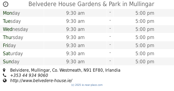
Belvedere House Gardens & Park
Mullingar
Park
read more
12.237 km
Town Park
Tullamore
Park
read more
12.294 km
Sutherland Park
Cappanageeragh
Park
read more
12.295 km
Tullamore Town Park
7-, 9 Cormac Street, Tullamore
Park
read more
12.636 km
Tullamore Tidy Towns Wild Garden
Kilcruttin, Tullamore
Park
read more
12.95 km
Doory woods
Doory, Silverbrook
Park
read more
13.004 km
Avonduv
Spollanstown Road, Tullamore
Park
read more
14.466 km
Clara Boardwalk
Nature Reserve Broadwalk
Park
read more
14.7 km
Clara Bog Nature Reserve
Ballycumber Road, Clara
Park
read more
15.038 km
4 Teach Na Greine
4 Teach Na Greine, Lynn Road, Mullingar
Park
read more
17.257 km
Mullingar Harriers Athletic Club
Mullingar
Park
read more
17.737 km
Whitefield Stables
Killowen
Park
read more
19.417 km
Saint Lomans Sports Ground
Irlanda
Park
read more
19.417 km
Saint Lomans Sports Ground
Ireland
Park
read more
19.417 km
Saint Lomans Sports Ground
Irland
Park
read more
22.863 km
The Offaly Way
Saint Manchan's Estate, Derrynagun, Ballycumber
Park
read more
26.241 km
Lough Boora Discovery Park
Boora Leabeg, Tullamore
Park
read more
26.406 km
Bird Watching Hut
53°13'01. 7°43'32., 4 Boora Avenue, Monamolin
Park
read more
28.245 km
River Barrow Walk
11-1 Spa Street, Droughill, Portarlington
Park
read more
28.776 km
Newcastle Wood
4 Newcastle Road, Cloonkeen
Park
read more
📑
all categories
Accounting
Administrative area level 1
Administrative area level 2
Airport
Amusement park
Aquarium
Art gallery
Atm
Bakery
Bank
Bar
Beauty salon
Bicycle store
Book store
Bowling alley
Bus station
Cafe
Campground
Car dealer
Car rental
Car repair
Car wash
Casino
Cemetery
Church
City hall
Clothing store
Colloquial area
Convenience store
Country
Courthouse
Dentist
Department store
Doctor
Electrician
Electronics store
Embassy
Establishment
Finance
Fire station
Florist
Food
Funeral home
Furniture store
Gas station
General contractor
Grocery or supermarket
Gym
Hair care
Hardware store
Health
Hindu Temple
Home goods store
Hospital
Insurance agency
Jewelry store
Laundry
Lawyer
Library
Light rail station
Liquor store
Local government office
Locality
Locksmith
Lodging
Meal delivery
Meal takeaway
Mosque
Movie rental
Movie theater
Moving company
Museum
Natural feature
Neighborhood
Night club
Painter
Park
Parking
Pet store
Pharmacy
Physiotherapist
Place of worship
Plumber
Point of interest
Police
Political
Post office
Premise
Real estate agency
Restaurant
Roofing contractor
Route
Rv park, camping
School
Shoe store
Shopping mall
Spa
Stadium
Storage
Store
Sublocality
Subpremise
Supermarket
Synagogue
Taxi stand
Train station
Transit station
Travel agency
University
Veterinary care
Zoo
sublocality level 1
↑