Parking nearby Island Road Car Park
Ireland
Parking nearby Island Road Car Park
Island Road Car Park
Island Road, Enniscorthy, IE Irlandia
contacts phone
:
+353
Latitude:
52.5053389
, Longitude:
-6.5696663
larger map & directions
read more
nearest Parking
341 m
Duffry Gate Car Park
Duffry Gate, Enniscorthy
Parking
read more
643 m
Cemetery Carpark
Blackstoops
Parking
read more
18.466 km
Carpark
1 Castlehill Bungalows, Ballinesker, Curracloe, Co. Wexford, Y21 FX27 Castlehill Bungalows, Ballinesker, Curracloe
Parking
read more
18.978 km
37 Glenbrook Parking
37 Glenbrook, Waterford
Parking
read more
19.249 km
Redmond Road Car Park
Redmond Road, Wexford
Parking
read more
19.348 km
Hill Street Car Park
Hill Street, Wexford
Parking
read more
19.371 km
Euro Car Parks
Ferrybank South, Wexford
Parking
read more
19.49 km
Redmond Square Car Park
Redmond Road, Wexford
Parking
read more
19.559 km
Ferrybank Car Park
Ferrybank
Parking
read more
19.628 km
Belvedere Car Park
Belvedere Road, Wexford
Parking
read more
19.844 km
Euro Car Parks
Common Quay Street, Wexford Town
Parking
read more
19.864 km
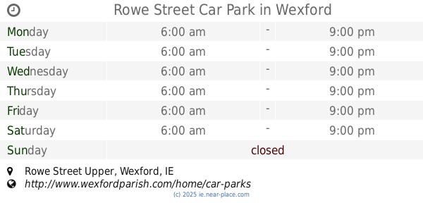
Rowe Street Car Park
Church of the Immaculate Conception, Rowe Street Upper, Wexford
Parking
read more
20.033 km
Crescent Quay Car Park
Wexford
Parking
read more
20.038 km
High Street Car Park
High Street, Wexford
Parking
read more
20.251 km
Euro Car Parks
Paul Quay, Wexford
Parking
read more
20.329 km
South Main Street Car Park
Oyster Lane, Wexford
Parking
read more
20.354 km
Talbot Hotel Car Park R730
The Quay, The Gap
Parking
read more
20.368 km
Bride Street Car Park
Church of the Assumption, Bride Street, Wexford
Parking
read more
21.534 km
Parking for Rocklands Crag
Mulgannon Road, Mulgannon, Wexford
Parking
read more
22.281 km
Morriscastle Public Car Park
Tinnacree
Parking
read more
23.761 km
Johnstown Castle Car Park
Johnstown Castle Estate
Parking
read more
25.198 km
Borris Viaduct Car Park
Clashganny
Parking
read more
26.006 km
Monaseed Car Park
Unnamed Road, Monaseed Demesne
Parking
read more
26.303 km
15 Railway Rd Parking
15 Railway Rd, Enniskerry
Parking
read more
26.311 km
Civic Centre car park
34 The Avenue, Gorey corporation lands
Parking
read more
📑
all categories
Accounting
Administrative area level 1
Administrative area level 2
Airport
Amusement park
Aquarium
Art gallery
Atm
Bakery
Bank
Bar
Beauty salon
Bicycle store
Book store
Bowling alley
Bus station
Cafe
Campground
Car dealer
Car rental
Car repair
Car wash
Casino
Cemetery
Church
City hall
Clothing store
Colloquial area
Convenience store
Country
Courthouse
Dentist
Department store
Doctor
Electrician
Electronics store
Embassy
Establishment
Finance
Fire station
Florist
Food
Funeral home
Furniture store
Gas station
General contractor
Grocery or supermarket
Gym
Hair care
Hardware store
Health
Hindu Temple
Home goods store
Hospital
Insurance agency
Jewelry store
Laundry
Lawyer
Library
Light rail station
Liquor store
Local government office
Locality
Locksmith
Lodging
Meal delivery
Meal takeaway
Mosque
Movie rental
Movie theater
Moving company
Museum
Natural feature
Neighborhood
Night club
Painter
Park
Parking
Pet store
Pharmacy
Physiotherapist
Place of worship
Plumber
Point of interest
Police
Political
Post office
Premise
Real estate agency
Restaurant
Roofing contractor
Route
Rv park, camping
School
Shoe store
Shopping mall
Spa
Stadium
Storage
Store
Sublocality
Subpremise
Supermarket
Synagogue
Taxi stand
Train station
Transit station
Travel agency
University
Veterinary care
Zoo
sublocality level 1
↑