Pharmacy nearby Ward Pharmacy
Coronavirus disease (COVID-19) Situation
confirmed cases
1734582
deaths
9491
Ireland
Pharmacy nearby Ward Pharmacy
Ward Pharmacy
53 Pearse Street, Ballina Ireland
contacts phone
:
+353
Latitude:
54.1136376
, Longitude:
-9.1551848
read more
nearest Pharmacy
42 m
Mc Kane's Pharmacy
O'Rahilly Street, Ballina
Pharmacy
read more
107 m
Quinns Life Pharmacy
Pearse Street, Mayo
Pharmacy
read more
185 m
Foody's Pharmacy
Market Square, Ballina
Pharmacy
read more
191 m
Molloys Lifestyle Pharmacy
Garden St, Ballina
Pharmacy
read more
271 m
McLoughlins Pharmacy
Humbert Street, Ballina
Pharmacy
read more
332 m
Mulligans Pharmacy
Kevin Barry Street, Ballina
Pharmacy
read more
1.003 km
Molloy's Lifestyle Pharmacy
Bunree Road, Ballina
Pharmacy
read more
3.014 km
Quinns Veterinary Surgery
3 Killala Road, Ballina
Pharmacy
read more
10.762 km
Geraghty's Pharmacy & Healthstore
Main Street, Crossmolina
Pharmacy
read more
10.84 km
Quinn's Chemist
Bridge Street, Crossmolina
Pharmacy
read more
23.135 km
O'Connells Pharmacy
16 Main Street
Pharmacy
read more
23.182 km
O'Donnell's Pharmacy
Market Street, Swineford
Pharmacy
read more
29.788 km
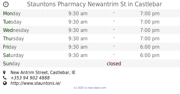
Stauntons Pharmacy Newantrim St
New Antrim Street, Castlebar
Pharmacy
read more
30.129 km
Rowlands Pharmacy
Main Street, Castlebar
Pharmacy
read more
31.061 km
Heneghans Pharmacy
Main Street, Kiltimagh
Pharmacy
read more
34.677 km
Life Pharmacy Balla
The Health Centre, Main Street, Balla
Pharmacy
read more
34.698 km
Life Pharmacy Balla
Main Street, Balla
Pharmacy
read more
42.395 km
Goldens Pharmacy
Bridge Street, Westport
Pharmacy
read more
44.5 km
Boots the Chemist
Clare
Pharmacy
read more
44.5 km
Boots
Clare
Pharmacy
read more
45 km
FLYNN'S PHARMACY
The Square, Claremorris
Pharmacy
read more
46.464 km
LotusWorks
LotusWorks Building 3, Finisklin Business Park, Sligo
Pharmacy
read more
47.749 km
Higgins Pharmacy
Teeling Street, Sligo
Pharmacy
read more
47.943 km
Markievicz Pharmacy
Holborn Hill, Sligo
Pharmacy
read more
49.402 km
Total Health Pharmacy
Riverstown
Pharmacy
read more
📑
all categories
Accounting
Administrative area level 1
Administrative area level 2
Airport
Amusement park
Aquarium
Art gallery
Atm
Bakery
Bank
Bar
Beauty salon
Bicycle store
Book store
Bowling alley
Bus station
Cafe
Campground
Car dealer
Car rental
Car repair
Car wash
Casino
Cemetery
Church
City hall
Clothing store
Colloquial area
Convenience store
Country
Courthouse
Dentist
Department store
Doctor
Electrician
Electronics store
Embassy
Establishment
Finance
Fire station
Florist
Food
Funeral home
Furniture store
Gas station
General contractor
Grocery or supermarket
Gym
Hair care
Hardware store
Health
Hindu Temple
Home goods store
Hospital
Insurance agency
Jewelry store
Laundry
Lawyer
Library
Light rail station
Liquor store
Local government office
Locality
Locksmith
Lodging
Meal delivery
Meal takeaway
Mosque
Movie rental
Movie theater
Moving company
Museum
Natural feature
Neighborhood
Night club
Painter
Park
Parking
Pet store
Pharmacy
Physiotherapist
Place of worship
Plumber
Point of interest
Police
Political
Post office
Premise
Real estate agency
Restaurant
Roofing contractor
Route
Rv park, camping
School
Shoe store
Shopping mall
Spa
Stadium
Storage
Store
Sublocality
Subpremise
Supermarket
Synagogue
Taxi stand
Train station
Transit station
Travel agency
University
Veterinary care
Zoo
sublocality level 1
↑