Point of interest nearby Fallon Marguees
Ireland
Point of interest nearby Fallon Marguees
Fallon Marguees
44 Athenry Road, Tuam Irlandia
contacts phone
:
+353
Latitude:
53.5073783
, Longitude:
-8.8435531
read more
nearest Point of interest
547 m
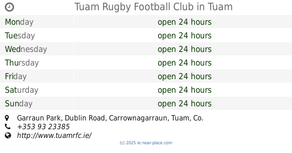
Tuam Rugby Football Club
Garraun Park, Dublin Road, Tuam
Point of interest
read more
587 m
Irish Wheelchair Association
Dublin Road, Tuam
Point of interest
read more
754 m
Daniel G. McGrath Solicitors
7 Dublin Road, Tuam
Point of interest
read more
855 m
Elite Service Station XL
Dublin Road, Tuam
Point of interest
read more
865 m
Geraghty Fashions
Bishop Street, Tuam
Point of interest
read more
885 m
The Sportsman's Inn
Vicar Street, Tuam
Point of interest
read more
885 m
Western Traveller & Intercultural Development
Church View, Vicar Street, Tuam
Point of interest
read more
908 m
Garveys Bakery
The Mall, Tuam
Point of interest
read more
1.006 km
Tuam Employment Services Office
High Street, Tuam
Point of interest
read more
1.013 km
McDonald Walsh & Company Chartered Accountants
Central House, Shop Street, Tuam
Point of interest
read more
1.033 km
Leaf and Bean Cafe
Bishop Street, Tuam
Cafe
Store
Restaurant
Point of interest
Food
Establishment
read more
1.058 km
Vincent Costello Agricultural Consultancy LTD
High Street, Tuam
Point of interest
read more
1.062 km
High Cross Pharmacy
High Street, Tuam
Point of interest
read more
1.106 km
Tuam Photo Studio
Temple Jarlath Court, High Street, Tuam
Point of interest
read more
1.145 km
BrainTech
Kiosk 2, Tuam shopping centre, Trinity court,, Tuam
Point of interest
read more
📑
all categories
Accounting
Administrative area level 1
Administrative area level 2
Airport
Amusement park
Aquarium
Art gallery
Atm
Bakery
Bank
Bar
Beauty salon
Bicycle store
Book store
Bowling alley
Bus station
Cafe
Campground
Car dealer
Car rental
Car repair
Car wash
Casino
Cemetery
Church
City hall
Clothing store
Colloquial area
Convenience store
Country
Courthouse
Dentist
Department store
Doctor
Electrician
Electronics store
Embassy
Establishment
Finance
Fire station
Florist
Food
Funeral home
Furniture store
Gas station
General contractor
Grocery or supermarket
Gym
Hair care
Hardware store
Health
Hindu Temple
Home goods store
Hospital
Insurance agency
Jewelry store
Laundry
Lawyer
Library
Light rail station
Liquor store
Local government office
Locality
Locksmith
Lodging
Meal delivery
Meal takeaway
Mosque
Movie rental
Movie theater
Moving company
Museum
Natural feature
Neighborhood
Night club
Painter
Park
Parking
Pet store
Pharmacy
Physiotherapist
Place of worship
Plumber
Point of interest
Police
Political
Post office
Premise
Real estate agency
Restaurant
Roofing contractor
Route
Rv park, camping
School
Shoe store
Shopping mall
Spa
Stadium
Storage
Store
Sublocality
Subpremise
Supermarket
Synagogue
Taxi stand
Train station
Transit station
Travel agency
University
Veterinary care
Zoo
sublocality level 1
↑