School nearby Annaghdown School
Ireland
School nearby Annaghdown School
Annaghdown School
Unnamed Rd, Irlanda
contacts phone
:
+353
Latitude:
53.3868176
, Longitude:
-9.0665823
read more
nearest School
4.983 km
Old Girls' School
Carrowbeg South, Corrandulla
School
read more
10.216 km
Dealers4Dealers
26 Maigh Riocaird, Galway
School
read more
10.847 km
Recess School
N59
School
read more
10.894 km
Scallywags Montessori & After School Child Care Centre
42 Tirellan Heights, Galway
School
read more
11.912 km
Laura's Laugh 'N' Learn Creche
Rosscahill
School
read more
12.129 km
St Annins School
Rosscahill
School
read more
12.18 km
Lakeview School
Renmore, Galway
School
read more
12.198 km
Holy Trinity National School
Mervue, Galway
School
read more
12.4 km
Yeats College
The Grammar School Building, College Road, Galway
School
read more
12.476 km
Naíonra Cháit
Bhuaile Beag N.S, Barna
School
read more
12.497 km
Celtic Hair College
1st floor, 4 Eyre Square, Galway
School
read more
12.675 km
Scoil Chaitríona, Renmore
Renmore, Ballyloughane Strand
School
read more
12.713 km
adult education nuigalway
Nun's Island, Galway
School
read more
12.715 km
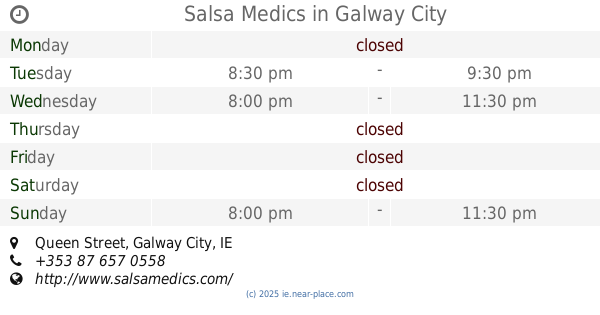
Salsa Medics
Victoria Hotel, Queen Street, Galway City
School
read more
12.73 km
Montessori &After School
47 Dun Na Mara, Galway
School
read more
12.835 km
scuola douguska
42 Túr Uisce, Doughiska
School
read more
13.002 km
Galway Bay Yoga
2 Small Crane, Square, Galway
School
read more
13.004 km
الحضانه١
11 Clybaun Road, Galway
School
read more
13.02 km
seville house
5-17 Sráid Na nDuganna Nua, Gaillimh
School
read more
13.251 km
Dominican College
Taylor's Hill, Galway
School
read more
13.626 km
1595 Club
Galway
School
read more
13.688 km
FYI - Food you're into
22 Ros Caoin, Galway
School
read more
15.636 km
Krav Maga WestSide
Carrowmoneash
School
read more
16.367 km
Orenmore Boys National School
Maree Road, Oran More, Oranmore
School
read more
20.254 km
St pats Gym
Parkmore, Tuam
School
read more
📑
all categories
Accounting
Administrative area level 1
Administrative area level 2
Airport
Amusement park
Aquarium
Art gallery
Atm
Bakery
Bank
Bar
Beauty salon
Bicycle store
Book store
Bowling alley
Bus station
Cafe
Campground
Car dealer
Car rental
Car repair
Car wash
Casino
Cemetery
Church
City hall
Clothing store
Colloquial area
Convenience store
Country
Courthouse
Dentist
Department store
Doctor
Electrician
Electronics store
Embassy
Establishment
Finance
Fire station
Florist
Food
Funeral home
Furniture store
Gas station
General contractor
Grocery or supermarket
Gym
Hair care
Hardware store
Health
Hindu Temple
Home goods store
Hospital
Insurance agency
Jewelry store
Laundry
Lawyer
Library
Light rail station
Liquor store
Local government office
Locality
Locksmith
Lodging
Meal delivery
Meal takeaway
Mosque
Movie rental
Movie theater
Moving company
Museum
Natural feature
Neighborhood
Night club
Painter
Park
Parking
Pet store
Pharmacy
Physiotherapist
Place of worship
Plumber
Point of interest
Police
Political
Post office
Premise
Real estate agency
Restaurant
Roofing contractor
Route
Rv park, camping
School
Shoe store
Shopping mall
Spa
Stadium
Storage
Store
Sublocality
Subpremise
Supermarket
Synagogue
Taxi stand
Train station
Transit station
Travel agency
University
Veterinary care
Zoo
sublocality level 1
↑