School nearby Carrickbeg National School
Ireland
School nearby Carrickbeg National School
Carrickbeg National School
Carrick On Suir Ireland
contacts phone
:
+353
Latitude:
52.3476495
, Longitude:
-7.4189708
read more
nearest School
Presentation Convent National School
Carrick On Suir
School
read more
266 m
Little Scholars Playschool
Greystone Street, Carrick On Suir
School
read more
297 m
Little Rascals Playgroup / Pre School
Rack Hill, Carrick Beg, Carrick on Suir
School
read more
508 m
Presentation Convent National School
Greenside South, Carrick-On-Suir
School
read more
567 m
Paddy Power
63 Main St, Carrick On Suir
School
read more
980 m
Christian Brothers Secondary School
33 Cregg Lawn, Carrick-On-Suir
School
read more
1.126 km
Marthas Montessori School
Castle Heights, Carrick On Suir
School
read more
1.333 km
CBS Carrick-on-Suir
Ballylynch, Carrick-On-Suir
School
read more
1.333 km
Scoil Mhuire
Greenhill, Carrick-On-Suir
School
read more
2.06 km
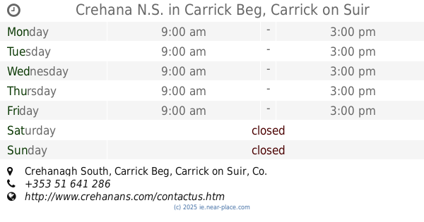
Crehana N.S.
Carrick Beg, Carrick on Suir
School
read more
2.088 km
Comeragh College
Tinvane, Carrick-On-Suir
School
read more
3.301 km
Rathgormack National School
Carrick-On-Suir
School
read more
4.37 km
mohober n.s.
Ballyneale National School, Carrick-On-Suir
School
read more
4.37 km
Janes Montessori
Ballyneale National School, Carrick On Suir
School
read more
6.198 km
Kildalton Agricultural College
R698, Banagher
School
read more
7.165 km
Rathgormack National School
R678, Rathgormack
School
read more
7.695 km
Clonea Power National School
Clonea Power
School
read more
9.703 km
Portlaw National School
Portlaw
School
read more
12.091 km
Scoil Mhuire National School
Mooncoin
School
read more
13.338 km
Colaiste Cois Siuire
Mooncoin
School
read more
13.788 km
Killurney National School
Ballypatrick, Clonmel
School
read more
16.064 km
Waterford Montessori School
St Belindas Parish Hall, Newtown
School
read more
16.281 km
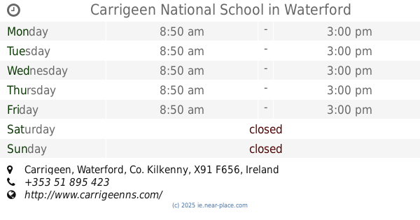
Carrigeen National School
Carrigeen, Waterford
School
read more
17.505 km
Mariki
Tuitestown
School
read more
19.538 km
Kilmacthomas school waterford
3, Bawnfune
School
read more
📑
all categories
Accounting
Administrative area level 1
Administrative area level 2
Airport
Amusement park
Aquarium
Art gallery
Atm
Bakery
Bank
Bar
Beauty salon
Bicycle store
Book store
Bowling alley
Bus station
Cafe
Campground
Car dealer
Car rental
Car repair
Car wash
Casino
Cemetery
Church
City hall
Clothing store
Colloquial area
Convenience store
Country
Courthouse
Dentist
Department store
Doctor
Electrician
Electronics store
Embassy
Establishment
Finance
Fire station
Florist
Food
Funeral home
Furniture store
Gas station
General contractor
Grocery or supermarket
Gym
Hair care
Hardware store
Health
Hindu Temple
Home goods store
Hospital
Insurance agency
Jewelry store
Laundry
Lawyer
Library
Light rail station
Liquor store
Local government office
Locality
Locksmith
Lodging
Meal delivery
Meal takeaway
Mosque
Movie rental
Movie theater
Moving company
Museum
Natural feature
Neighborhood
Night club
Painter
Park
Parking
Pet store
Pharmacy
Physiotherapist
Place of worship
Plumber
Point of interest
Police
Political
Post office
Premise
Real estate agency
Restaurant
Roofing contractor
Route
Rv park, camping
School
Shoe store
Shopping mall
Spa
Stadium
Storage
Store
Sublocality
Subpremise
Supermarket
Synagogue
Taxi stand
Train station
Transit station
Travel agency
University
Veterinary care
Zoo
sublocality level 1
↑