School nearby Carrigeen NS CoderDojo
Ireland
School nearby Carrigeen NS CoderDojo
Carrigeen NS CoderDojo
Corluddy, Co. Kilkenny, Ireland
contacts phone
:
+353
website:
zen.coderdojo.com
Latitude:
52.2705019
, Longitude:
-7.214529
larger map & directions
read more
nearest School
70 m
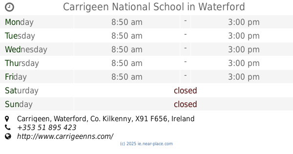
Carrigeen National School
Carrigeen, Waterford
School
read more
153 m
Carrigeen Community Playschool
Carrigeen Parish Hall, Carrigeen
School
read more
3.099 km
Colaiste Cois Siuire
Mooncoin
School
read more
3.154 km
Coláiste Cois Siúire (second level school)
Filbuckstown
School
read more
4.248 km
Kilmacthomas school waterford
3, Bawnfune
School
read more
4.327 km
Scoil Mhuire National School
Mooncoin
School
read more
4.57 km
Waterford Montessori School
St Belindas Parish Hall, Newtown
School
read more
4.682 km
Gaelscoil na Déise
Waterford
School
read more
4.752 km
Waterford Educate Together National School
Waterford Educate Together N.S. Carrickpherish Rd
School
read more
4.908 km
Waterford Childcare Centre
Unit 607, Northern Extension,, Industrial Park, Waterford
School
read more
5.582 km
St Joseph Girls National School
Greenville
School
read more
5.625 km
Ballyduff National School
Ballyduff National School, Ballyduff West, Ballyduff
School
read more
5.788 km
St Saviours National School
Ballybeg, Waterford
School
read more
5.846 km
Scoil Mhuire Butlerstown
Kilronan, Kilmanahan
School
read more
6.041 km
Our Lady of Mercy Secondary School
Ozanam Street, Waterford
School
read more
6.129 km
Adult Education Centre, Ozanam Street
Ozanam Street, Waterford
School
read more
6.183 km
Meánscoil Mhuire Na Trócaire
Ozanam Street, Waterford
School
read more
6.353 km
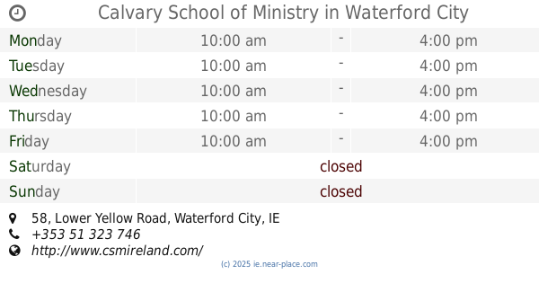
Calvary School of Ministry
58 Lower Yellow Road, Waterford City
School
read more
7.381 km
St Angela’s Ursuline Secondary School
Ballytruckle Road, Waterford
School
read more
7.513 km
Saint Martin's School
Ballytruckle Road, Ballytruckle, Waterford
School
read more
10.078 km
Slieverue Primary School
Waterford
School
read more
10.155 km
Slieverue N.S.
via Waterford
School
read more
12.167 km
Fenor National School
Fenor, Tramore
School
read more
13.119 km
Freedom Surf School - Bilingual Adventure Education Centre
Freedom Surf School- Bilingual Adventure Education Centre, The Gap, Riverstown, Co Waterford
School
read more
16.287 km
Kilmacthomas Montessori
Old Road, Kilmacthomas
School
read more
📑
all categories
Accounting
Administrative area level 1
Administrative area level 2
Airport
Amusement park
Aquarium
Art gallery
Atm
Bakery
Bank
Bar
Beauty salon
Bicycle store
Book store
Bowling alley
Bus station
Cafe
Campground
Car dealer
Car rental
Car repair
Car wash
Casino
Cemetery
Church
City hall
Clothing store
Colloquial area
Convenience store
Country
Courthouse
Dentist
Department store
Doctor
Electrician
Electronics store
Embassy
Establishment
Finance
Fire station
Florist
Food
Funeral home
Furniture store
Gas station
General contractor
Grocery or supermarket
Gym
Hair care
Hardware store
Health
Hindu Temple
Home goods store
Hospital
Insurance agency
Jewelry store
Laundry
Lawyer
Library
Light rail station
Liquor store
Local government office
Locality
Locksmith
Lodging
Meal delivery
Meal takeaway
Mosque
Movie rental
Movie theater
Moving company
Museum
Natural feature
Neighborhood
Night club
Painter
Park
Parking
Pet store
Pharmacy
Physiotherapist
Place of worship
Plumber
Point of interest
Police
Political
Post office
Premise
Real estate agency
Restaurant
Roofing contractor
Route
Rv park, camping
School
Shoe store
Shopping mall
Spa
Stadium
Storage
Store
Sublocality
Subpremise
Supermarket
Synagogue
Taxi stand
Train station
Transit station
Travel agency
University
Veterinary care
Zoo
sublocality level 1
↑