School nearby Klub Muzik
Ireland
School nearby Klub Muzik
Klub Muzik
Crobally Lower, Tramore, Co. Condado de Waterford, Irlanda
contacts phone
:
+353 87 957 7661
website:
klubmuzik.ie
Latitude:
52.1680191
, Longitude:
-7.1403349
larger map & directions
read more
nearest School
406 m
Naíonra Philib Barún
Gaelscoil Philib Barún, Crobally Upper, Tramore
School
read more
445 m
Gaelscoil Philib Barún
1 Springmount, Tramore
School
read more
497 m
Saffron Yoga
Tramore Landfill and Civic Amenity Site, 2, Riverstown Business Park, Tramore
School
read more
725 m
Freedom Surf School - Bilingual Adventure Education Centre
Freedom Surf School- Bilingual Adventure Education Centre, The Gap, Riverstown, Co Waterford
School
read more
745 m
The Meeting Place
Upper Branch Road, Tramore
School
read more
789 m
Ard Na Ghleanna Childcare Service
Glen Road, Árd Na Groí, Tramore
School
read more
797 m
Tramore Educate Together N.S.
Tramore Health Centre, Pond Road, Tramore
School
read more
848 m
Glór Na Mara Primary School
Convent Hill, Tramore
School
read more
914 m
Star of Sea Pre School
Convent Hill, Tramore
School
read more
914 m
Glor na Mara Pre-School
Convent Hill, Tramore
School
read more
942 m
Tramore Surf Lifesaving Centre
Tramore West, Tramore
School
read more
1.059 km
Paddy Power
Turkey Road, Tramore, Co Waterford
School
read more
1.238 km
Ladybird Preschool
Moonvoy Bridge, Crobally Upper, Tramore
School
read more
1.507 km
Tramore Babywearing Meet & Sling Library
Tramore West, Tramore
School
read more
1.513 km
Ardscoil na Mara
Summerhill Rise, Tramore
School
read more
1.533 km
Tiny Tots Community Playschool
Tramore
School
read more
1.934 km
Holy Cross School
Ballycarnane, Tramore
School
read more
1.985 km
Sunny Days
Elm Park, Tramore
School
read more
2.623 km
Dunmore East Sea School
Woodview, Drumcannon, Tramore
School
read more
6.157 km
Fenor National School
Fenor, Tramore
School
read more
6.278 km
Holy Cross National School
Newtown Road, Tramore
School
read more
8.432 km
Saint Martin's School
Ballytruckle Road, Ballytruckle, Waterford
School
read more
10.219 km
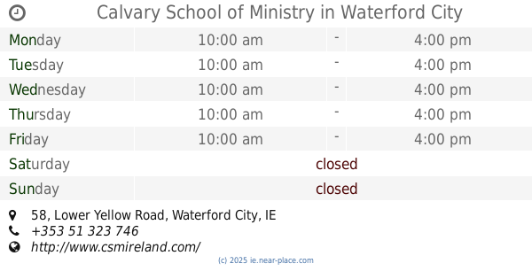
Calvary School of Ministry
58 Lower Yellow Road, Waterford City
School
read more
10.298 km
Our Lady of Mercy Secondary School
Ozanam Street, Waterford
School
read more
16.501 km
Scoil Mhuire National School
Mooncoin
School
read more
📑
all categories
Accounting
Administrative area level 1
Administrative area level 2
Airport
Amusement park
Aquarium
Art gallery
Atm
Bakery
Bank
Bar
Beauty salon
Bicycle store
Book store
Bowling alley
Bus station
Cafe
Campground
Car dealer
Car rental
Car repair
Car wash
Casino
Cemetery
Church
City hall
Clothing store
Colloquial area
Convenience store
Country
Courthouse
Dentist
Department store
Doctor
Electrician
Electronics store
Embassy
Establishment
Finance
Fire station
Florist
Food
Funeral home
Furniture store
Gas station
General contractor
Grocery or supermarket
Gym
Hair care
Hardware store
Health
Hindu Temple
Home goods store
Hospital
Insurance agency
Jewelry store
Laundry
Lawyer
Library
Light rail station
Liquor store
Local government office
Locality
Locksmith
Lodging
Meal delivery
Meal takeaway
Mosque
Movie rental
Movie theater
Moving company
Museum
Natural feature
Neighborhood
Night club
Painter
Park
Parking
Pet store
Pharmacy
Physiotherapist
Place of worship
Plumber
Point of interest
Police
Political
Post office
Premise
Real estate agency
Restaurant
Roofing contractor
Route
Rv park, camping
School
Shoe store
Shopping mall
Spa
Stadium
Storage
Store
Sublocality
Subpremise
Supermarket
Synagogue
Taxi stand
Train station
Transit station
Travel agency
University
Veterinary care
Zoo
sublocality level 1
↑