School nearby Lilliput Childcare Rathdrum
Ireland
School nearby Lilliput Childcare Rathdrum
Lilliput Childcare Rathdrum
Beechlawn, Corballis Upper, Rathdrum Irland
contacts phone
:
+353
Latitude:
52.9232581
, Longitude:
-6.2398786
read more
nearest School
920 m
Butt Poo
7 Parnell Park, Rathdrum, Co. Wicklow, A67 NW58 Parnell Park, Rathdrum
School
read more
1.024 km
Paddy Power
29 Market Square, Rathdrum
School
read more
1.166 km
Avondale Community College
Rathdrum
School
read more
1.166 km
St Saviours National School
Rathdrum
School
read more
4.88 km
Toddlers Haven Montessori Pre-school
Ballygannon More
School
read more
9.578 km
Helena Brennan Porcelain
Unnamed Road
School
read more
9.787 km
Spruce Lodge
Ballyrogan Upper
School
read more
12.93 km
Cole Potterspoint
Ballynacarrig
School
read more
12.979 km
Ashvale Creche
Ashvale House, Ballynerrin Upper, Wicklow
School
read more
13.023 km
Naíonra Chill Mhantáin
1 Graham's Court, Wicklow
School
read more
13.091 km
Tiny Tots Pre School
8A, Merrymeeting, Rathnew
School
read more
13.479 km
Ashford Montessori School
R772
School
read more
14.239 km
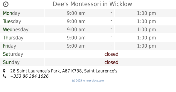
Dee's Montessori
28 Saint Laurence's Park, A67 K738 Saint Laurence's Park, Wicklow
School
read more
14.386 km
Gaelscoil Chill Mhantain
Wicklow
School
read more
14.697 km
Dominican College
Wicklow
School
read more
14.747 km
Holy Rosary Secondary School
6 Crinion Park, Wicklow
School
read more
14.777 km
ST johns senior natinol school
10 Coolgreaney Road, Arklow
School
read more
14.83 km
Glenart College
Coolgreaney Road, Arklow
School
read more
14.989 km
Scoil Naomh Padraig
Bearna Chle, Arklow
School
read more
15.089 km
Blackberry Acadamey
1-, 11 Saint Mary's Road, Arklow
School
read more
15.207 km
Treasures' Montessori Preschool
Dunbur Road, Wicklow
School
read more
15.236 km
Saint Mary's Girls National School
54 Connolly Street, Arklow
School
read more
15.277 km
Smarties Pre-School
18 Glenvale Park, Wicklow
School
read more
15.289 km
St Michael and Peter's Junior School
Saint Mary's Road, Abbeylands, Arklow
School
read more
15.636 km
Carysfort Mixed National School
Yellow Lane, Arklow
School
read more
📑
all categories
Accounting
Administrative area level 1
Administrative area level 2
Airport
Amusement park
Aquarium
Art gallery
Atm
Bakery
Bank
Bar
Beauty salon
Bicycle store
Book store
Bowling alley
Bus station
Cafe
Campground
Car dealer
Car rental
Car repair
Car wash
Casino
Cemetery
Church
City hall
Clothing store
Colloquial area
Convenience store
Country
Courthouse
Dentist
Department store
Doctor
Electrician
Electronics store
Embassy
Establishment
Finance
Fire station
Florist
Food
Funeral home
Furniture store
Gas station
General contractor
Grocery or supermarket
Gym
Hair care
Hardware store
Health
Hindu Temple
Home goods store
Hospital
Insurance agency
Jewelry store
Laundry
Lawyer
Library
Light rail station
Liquor store
Local government office
Locality
Locksmith
Lodging
Meal delivery
Meal takeaway
Mosque
Movie rental
Movie theater
Moving company
Museum
Natural feature
Neighborhood
Night club
Painter
Park
Parking
Pet store
Pharmacy
Physiotherapist
Place of worship
Plumber
Point of interest
Police
Political
Post office
Premise
Real estate agency
Restaurant
Roofing contractor
Route
Rv park, camping
School
Shoe store
Shopping mall
Spa
Stadium
Storage
Store
Sublocality
Subpremise
Supermarket
Synagogue
Taxi stand
Train station
Transit station
Travel agency
University
Veterinary care
Zoo
sublocality level 1
↑