School nearby Our Lady's College Galway
Ireland
School nearby Our Lady's College Galway
Our Lady's College Galway
Presentation Road Irland
contacts phone
:
+353
Latitude:
53.2736787
, Longitude:
-9.0597415
read more
nearest School
146 m
Saint Joseph's Patrician College - The Bish
Nun's Island, Galway
School
read more
195 m
Galway Study Centre
1-, 11 Mill Street, Galway
School
read more
200 m
adult education nuigalway
Nun's Island, Galway
School
read more
313 m
College Language
Bridge Street, Galway
School
read more
328 m
Saint Patrick's School
7 Lombard Street
School
read more
383 m
The Jesuit
20 Raleigh Row
School
read more
395 m
Mean Scoil Mhuire
Newtownsmith
School
read more
419 m
Galway Bay Yoga
2 Small Crane, Square, Galway
School
read more
455 m
Mercy Primary School
Saint Francis Street
School
read more
467 m
St. Nicholas’ Parochial School
Waterside, Galway
School
read more
472 m
Clinical Research Facility Galway
Galway
School
read more
490 m
The Jes
Sea Road, Galway
School
read more
508 m
Paddy Power
13 Woodquay, Galway
School
read more
534 m
Colegio De Teresa y Alice
11-, 21 Sea Road, Galway
School
read more
542 m
Mayoralty House
14 Saint Augustine Street, Galway
School
read more
545 m
Ionad na hOllscoile, Áras na Gaeilge
16 Lower Newcastle, Galway
School
read more
639 m
seville house
5-17 Sráid Na nDuganna Nua, Gaillimh
School
read more
668 m
Siobhan McKenna Theatre
20 Lower Newcastle, Galway
School
read more
669 m
Hardiman Research Building
NUI, Galway
School
read more
705 m
Blackstone Launchpad NUI Galway
Blackstone Launchpad NUIG, The Concourse, NUIG,, Galway
School
read more
742 m
Celtic Hair College
1st floor, 4 Eyre Square, Galway
School
read more
747 m
Catholic Legion of Mary
42 Father Griffin Road, Galway
School
read more
779 m
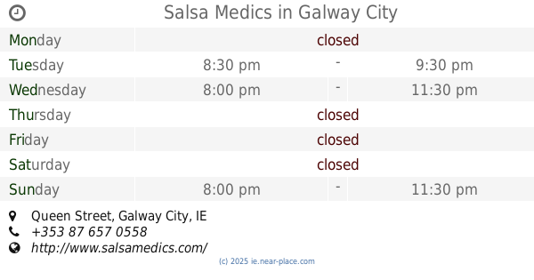
Salsa Medics
Victoria Hotel, Queen Street, Galway City
School
read more
797 m
Westside Community Creche and Preschool
46A Ashe Road, Shantalla
School
read more
936 m
St Josephs Training Centre
Snipe Avenue, Galway
School
read more
📑
all categories
Accounting
Administrative area level 1
Administrative area level 2
Airport
Amusement park
Aquarium
Art gallery
Atm
Bakery
Bank
Bar
Beauty salon
Bicycle store
Book store
Bowling alley
Bus station
Cafe
Campground
Car dealer
Car rental
Car repair
Car wash
Casino
Cemetery
Church
City hall
Clothing store
Colloquial area
Convenience store
Country
Courthouse
Dentist
Department store
Doctor
Electrician
Electronics store
Embassy
Establishment
Finance
Fire station
Florist
Food
Funeral home
Furniture store
Gas station
General contractor
Grocery or supermarket
Gym
Hair care
Hardware store
Health
Hindu Temple
Home goods store
Hospital
Insurance agency
Jewelry store
Laundry
Lawyer
Library
Light rail station
Liquor store
Local government office
Locality
Locksmith
Lodging
Meal delivery
Meal takeaway
Mosque
Movie rental
Movie theater
Moving company
Museum
Natural feature
Neighborhood
Night club
Painter
Park
Parking
Pet store
Pharmacy
Physiotherapist
Place of worship
Plumber
Point of interest
Police
Political
Post office
Premise
Real estate agency
Restaurant
Roofing contractor
Route
Rv park, camping
School
Shoe store
Shopping mall
Spa
Stadium
Storage
Store
Sublocality
Subpremise
Supermarket
Synagogue
Taxi stand
Train station
Transit station
Travel agency
University
Veterinary care
Zoo
sublocality level 1
↑