School nearby St Pauls Secondary School
Ireland
School nearby St Pauls Secondary School
St Pauls Secondary School
Hopkin's Lane, Monasterevin, IE Irlanda
contacts phone
:
+353 45 525 601
website:
stpaulsmonasterevin.ie
Latitude:
53.1424091
, Longitude:
-7.0658921
larger map & directions
read more
nearest School
St Paul's Secondary School
Hopkin's Lane, Monasterevin
School
read more
88 m
St Peters National School
Monasterevin
School
read more
91 m
St peters and pauls secondy school
West End
School
read more
451 m
Barrow mill
Monasterevin
School
read more
451 m
Monasterevin Convent Girls National School
Monasterevin
School
read more
453 m
Scoil Phadraig Naofa
Monasterevin Road, Athy
School
read more
564 m
Bright Eyes Preschool
old grange wood, monastery vintage, Rathangan
School
read more
3.569 km
Griffth Halls Sth. Circular road
Derry
School
read more
3.569 km
Ursuline Thurles
Derry
School
read more
4.564 km
Eduard Locklan
Derry
School
read more
4.687 km
Scoil Bhride, Lackagh
Monasterevin Rd
School
read more
5.073 km
Bambinos Creche
fisherstown ballybrittas, Portlaoise
School
read more
5.642 km
Kildangan National School
Derry
School
read more
10.41 km
Paddy Power
Claregate Street, Kildare Town, Co Kildare
School
read more
10.613 km
Emo National School
Emo, Portlaoise
School
read more
12.373 km
Stables
Unnamed Road, Ironhills
School
read more
14.949 km
Stradbally Montessori Pre School
Stradbally Boys National School, Vicarstown Rd, Stradbally
School
read more
17.4 km
Busy Bees Playschool
Pluckerstown, Kilmeague, Naas
School
read more
17.563 km
St. Mary's CBS
Borris Road, Portlaoise
School
read more
17.713 km
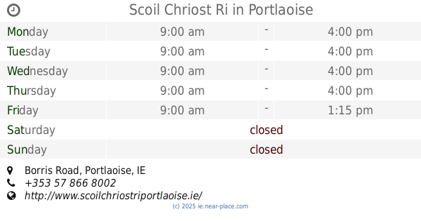
Scoil Chriost Ri
Borris Road, Portlaoise
School
read more
18.426 km
Happy Days Pre-School And Montessori
Borris Little, Portlaoise
School
read more
18.458 km
The Kolbe Special School
Block Road, Portlaoise
School
read more
18.878 km
Holy Family Senior School
Aughnaharna, Portlaoise
School
read more
19.159 km
Mariborough (Church of Ireland) National School
Sumerhill, The Eircode:R32HY24, Downs, Portlaoise
School
read more
19.319 km
Portlaoise ETNS
Downs
School
read more
📑
all categories
Accounting
Administrative area level 1
Administrative area level 2
Airport
Amusement park
Aquarium
Art gallery
Atm
Bakery
Bank
Bar
Beauty salon
Bicycle store
Book store
Bowling alley
Bus station
Cafe
Campground
Car dealer
Car rental
Car repair
Car wash
Casino
Cemetery
Church
City hall
Clothing store
Colloquial area
Convenience store
Country
Courthouse
Dentist
Department store
Doctor
Electrician
Electronics store
Embassy
Establishment
Finance
Fire station
Florist
Food
Funeral home
Furniture store
Gas station
General contractor
Grocery or supermarket
Gym
Hair care
Hardware store
Health
Hindu Temple
Home goods store
Hospital
Insurance agency
Jewelry store
Laundry
Lawyer
Library
Light rail station
Liquor store
Local government office
Locality
Locksmith
Lodging
Meal delivery
Meal takeaway
Mosque
Movie rental
Movie theater
Moving company
Museum
Natural feature
Neighborhood
Night club
Painter
Park
Parking
Pet store
Pharmacy
Physiotherapist
Place of worship
Plumber
Point of interest
Police
Political
Post office
Premise
Real estate agency
Restaurant
Roofing contractor
Route
Rv park, camping
School
Shoe store
Shopping mall
Spa
Stadium
Storage
Store
Sublocality
Subpremise
Supermarket
Synagogue
Taxi stand
Train station
Transit station
Travel agency
University
Veterinary care
Zoo
sublocality level 1
↑