School nearby Strangsmills National School
Ireland
School nearby Strangsmills National School
Strangsmills National School
Strangsmill, Kilmacow, Co. Kilkenny, Irland
contacts phone
:
+353 51 874 474
website:
www.strangsmillsns.ie
Latitude:
52.2933952
, Longitude:
-7.1359039
larger map & directions
read more
nearest School
1.18 km
Hopscotch Day Nursery
Mullinabro
School
read more
3.277 km
Strumming aLong
34 Carn Glas Way, Gracedieu
School
read more
3.436 km
St Joseph Girls National School
Greenville
School
read more
3.582 km
Youthreach
66 O'Connell Street, Waterford
School
read more
3.679 km
Adult Education Centre, Ozanam Street
Ozanam Street, Waterford
School
read more
3.692 km
St. Senan's National School
Greenville
School
read more
3.725 km
Our Lady of Mercy Secondary School
Ozanam Street, Waterford
School
read more
3.755 km
St Marys Boys School
Ross Road, Waterford
School
read more
3.757 km
Scoil Mhuire an Port Mór
Ross Road, Ferrybank, Waterford
School
read more
3.763 km
An Teaghleigh Naofa
Our Lady of Mercy Senior National School, Military Road, Waterford
School
read more
3.766 km
Meánscoil Mhuire Na Trócaire
Ozanam Street, Waterford
School
read more
3.84 km
Ferrybank Parish Hall
Ross Road, Ferrybank
School
read more
3.89 km
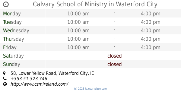
Calvary School of Ministry
58 Lower Yellow Road, Waterford City
School
read more
4.023 km
St stephen's De La Salle Primary School
25 Patrick Street, Waterford
School
read more
4.128 km
Paddy Power
42 Michael Street, Waterford
School
read more
4.299 km
Mount Sion Primary School
Barrack Street, Waterford
School
read more
4.375 km
Manor School
3 Manor Street, Waterford
School
read more
4.635 km
St Pauls Community College
Paddy Browne's Road, Lisduggan, Waterford
School
read more
4.635 km
Saint Paul's Community College
Brownes Road, Lisduggan
School
read more
4.753 km
Head Start Montessori
67 Springfields
School
read more
4.76 km
Slieverue Primary School
Waterford
School
read more
4.775 km
Waterpark
Swiss Cottage, 11 Newtown Road, Waterford
School
read more
4.831 km
Slieverue N.S.
via Waterford
School
read more
5.125 km
St John of God
Passage Road, Waterford
School
read more
5.475 km
Dunmore East Montessori
Avalon, Grange Park Avenue, Dunmore East
School
read more
📑
all categories
Accounting
Administrative area level 1
Administrative area level 2
Airport
Amusement park
Aquarium
Art gallery
Atm
Bakery
Bank
Bar
Beauty salon
Bicycle store
Book store
Bowling alley
Bus station
Cafe
Campground
Car dealer
Car rental
Car repair
Car wash
Casino
Cemetery
Church
City hall
Clothing store
Colloquial area
Convenience store
Country
Courthouse
Dentist
Department store
Doctor
Electrician
Electronics store
Embassy
Establishment
Finance
Fire station
Florist
Food
Funeral home
Furniture store
Gas station
General contractor
Grocery or supermarket
Gym
Hair care
Hardware store
Health
Hindu Temple
Home goods store
Hospital
Insurance agency
Jewelry store
Laundry
Lawyer
Library
Light rail station
Liquor store
Local government office
Locality
Locksmith
Lodging
Meal delivery
Meal takeaway
Mosque
Movie rental
Movie theater
Moving company
Museum
Natural feature
Neighborhood
Night club
Painter
Park
Parking
Pet store
Pharmacy
Physiotherapist
Place of worship
Plumber
Point of interest
Police
Political
Post office
Premise
Real estate agency
Restaurant
Roofing contractor
Route
Rv park, camping
School
Shoe store
Shopping mall
Spa
Stadium
Storage
Store
Sublocality
Subpremise
Supermarket
Synagogue
Taxi stand
Train station
Transit station
Travel agency
University
Veterinary care
Zoo
sublocality level 1
↑