School nearby Yeats College
Ireland
School nearby Yeats College
Yeats College
College Road, Galway Ireland
contacts phone
:
+353
Latitude:
53.276503
, Longitude:
-9.042031
read more
nearest School
28 m
Yeats College
The Grammar School Building, College Road, Galway
School
read more
180 m
St. Senans School Of MUA
H91 YE8F, 34 College Road
School
read more
482 m
Celtic Hair College
4 Eyre Square, Galway
School
read more
482 m
Celtic Hair College
1st floor, 4 Eyre Square, Galway
School
read more
561 m
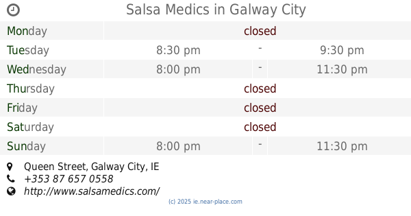
Salsa Medics
Victoria Hotel, Queen Street, Galway City
School
read more
586 m
Teach Mhuire Bohermore Community Pre School
13 St Finbars Terrace, Bohermore, Galway
School
read more
727 m
Paddy Power
13 Woodquay, Galway
School
read more
762 m
Paddy Power
The Huntsman, 162 College Road, Galway
School
read more
787 m
Mercy Primary School
Saint Francis Street
School
read more
787 m
Mercy Primary School
Saint Francis Street, Galway
School
Point of interest
Establishment
read more
795 m
SALI Childcare Services Ltd.
Saint Francis Street, Galway
School
read more
815 m
River position 1
Galway
School
read more
821 m
St. Nicholas’ Parochial School
Waterside, Galway
School
read more
825 m
Mean Scoil Muire
Newtownsmith
School
read more
825 m
Mean Scoil Mhuire
Newtownsmith
School
read more
903 m
Bow Waves Pontoon
Galway
School
read more
928 m
Mayoralty House
14 Saint Augustine Street, Galway
School
read more
952 m
Rosedale School
Woodlands Centre, Old Dublin Road, Renmore
School
read more
957 m
Saint Patrick's School
7 Lombard Street
School
read more
960 m
Performing Arts School Galway
Unit 6 Addley Business Park Liosban Industrial Estate beside First Stop Tyres, Tuam Road, Galway
University
School
Point of interest
Establishment
read more
972 m
Lakeview School
Renmore, Galway
School
read more
972 m
Seeblick Schule
Renmore, Galway
School
read more
994 m
seville house
5-17 Sráid Na nDuganna Nua, Gaillimh
School
read more
1.112 km
College Language
Bridge Street, Galway
School
read more
1.26 km
Claddagh Piscatorial School
Galway
School
read more
📑
all categories
Accounting
Administrative area level 1
Administrative area level 2
Airport
Amusement park
Aquarium
Art gallery
Atm
Bakery
Bank
Bar
Beauty salon
Bicycle store
Book store
Bowling alley
Bus station
Cafe
Campground
Car dealer
Car rental
Car repair
Car wash
Casino
Cemetery
Church
City hall
Clothing store
Colloquial area
Convenience store
Country
Courthouse
Dentist
Department store
Doctor
Electrician
Electronics store
Embassy
Establishment
Finance
Fire station
Florist
Food
Funeral home
Furniture store
Gas station
General contractor
Grocery or supermarket
Gym
Hair care
Hardware store
Health
Hindu Temple
Home goods store
Hospital
Insurance agency
Jewelry store
Laundry
Lawyer
Library
Light rail station
Liquor store
Local government office
Locality
Locksmith
Lodging
Meal delivery
Meal takeaway
Mosque
Movie rental
Movie theater
Moving company
Museum
Natural feature
Neighborhood
Night club
Painter
Park
Parking
Pet store
Pharmacy
Physiotherapist
Place of worship
Plumber
Point of interest
Police
Political
Post office
Premise
Real estate agency
Restaurant
Roofing contractor
Route
Rv park, camping
School
Shoe store
Shopping mall
Spa
Stadium
Storage
Store
Sublocality
Subpremise
Supermarket
Synagogue
Taxi stand
Train station
Transit station
Travel agency
University
Veterinary care
Zoo
sublocality level 1
↑