Atm nearby Ulster Bank ATM
Ireland
Atm nearby Ulster Bank ATM
Ulster Bank ATM
Bandon Road, Garranedarragh, Cork Irland
contacts phone
:
+353
Latitude:
51.8717818
, Longitude:
-8.5223597
read more
nearest Atm
130 m
CashZone ATM
Bishopstown House, Ardarostig, Waterfall
Atm
read more
979 m
Permanent TSB ATM
Permanent TSB, 1, Curraheen Road, Bishopstown, Cork
Atm
read more
1.265 km
Ulster Bank ATM
Ulster Bank, High Street Centre, Bishopstown Road, Cork
Atm
read more
1.382 km
Ulster Bank ATM
Tesco, Wilton Shopping Centre, Wilton, Cork
Atm
read more
1.441 km
Bank of Ireland ATM
Bank of Ireland, Wilton Shopping Centre, Wilton, Cork
Atm
read more
1.708 km
ATM (Bank Of Ireland)
Bishopstown, Cork
Atm
read more
2.237 km
ATM tesco
Sunday's Well, Cork
Atm
read more
2.651 km
BOI ATM
Brookfield Health Sciences Complex, College Road, Cork
Atm
read more
2.678 km
AIB ATM
Ryan's SuperValu, Togher Road, The Lough
Atm
read more
2.682 km
AIB ATM
The Lough, Togher Road
Atm
read more
2.821 km
Bank of Ireland ATM
8 Western Road, Cork
Atm
read more
2.826 km
AIB ATM
Western Road, Cork
Atm
read more
2.967 km
ATM Daybreak
60 College Rd, The Lough, Cork, T12 HW58 College Road, The Lough, Cork
Atm
read more
3.018 km
SPAR ATM
Spar, Pearse Square, Ballyphehane, Cork
Atm
read more
3.116 km
Bank of Ireland
University College, Cork
Atm
read more
3.16 km
AIB ATM
Centra, 10 Denroches Cross, Cork
Atm
read more
3.377 km
Bank of Ireland
Cork Airport
Atm
read more
3.412 km
Bank of Ireland ATM
Lehenagh More
Atm
read more
3.426 km
Bank Of Ireland
Kinsale Road, Cork
Atm
read more
3.548 km
CashZone ATM
Kinsale Road, Frankfield, Cork
Atm
read more
3.856 km
CashZone ATM
Airport Road, Cork
Atm
read more
4.063 km
AIB ATM
Mardyke Bowl, Mardyke Entertainment Complex, Sheares Street, Cork
Atm
read more
4.099 km
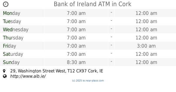
Bank of Ireland ATM
Centra, 29 Washington Street West, Cork
Atm
read more
4.886 km
Centra Atm
184-185 South Douglas Road, Ballinlough, Cork
Atm
read more
4.983 km
ATM in Spar
48 MacCurtain Street, Cork
Atm
read more
📑
all categories
Accounting
Administrative area level 1
Administrative area level 2
Airport
Amusement park
Aquarium
Art gallery
Atm
Bakery
Bank
Bar
Beauty salon
Bicycle store
Book store
Bowling alley
Bus station
Cafe
Campground
Car dealer
Car rental
Car repair
Car wash
Casino
Cemetery
Church
City hall
Clothing store
Colloquial area
Convenience store
Country
Courthouse
Dentist
Department store
Doctor
Electrician
Electronics store
Embassy
Establishment
Finance
Fire station
Florist
Food
Funeral home
Furniture store
Gas station
General contractor
Grocery or supermarket
Gym
Hair care
Hardware store
Health
Hindu Temple
Home goods store
Hospital
Insurance agency
Jewelry store
Laundry
Lawyer
Library
Light rail station
Liquor store
Local government office
Locality
Locksmith
Lodging
Meal delivery
Meal takeaway
Mosque
Movie rental
Movie theater
Moving company
Museum
Natural feature
Neighborhood
Night club
Painter
Park
Parking
Pet store
Pharmacy
Physiotherapist
Place of worship
Plumber
Point of interest
Police
Political
Post office
Premise
Real estate agency
Restaurant
Roofing contractor
Route
Rv park, camping
School
Shoe store
Shopping mall
Spa
Stadium
Storage
Store
Sublocality
Subpremise
Supermarket
Synagogue
Taxi stand
Train station
Transit station
Travel agency
University
Veterinary care
Zoo
sublocality level 1
↑