Cafe nearby Insomnia
Ireland
Cafe nearby Insomnia
Insomnia
131 Leeson Street Upper, Dublin Irland
contacts phone
:
+353
Latitude:
53.3304678
, Longitude:
-6.2515501
read more
nearest Cafe
493 m
Cafe Sol
33 Hatch Street Lower, Dublin
Cafe
read more
632 m
Lock 6 Cafe
Canal Road, Dublin
Cafe
read more
646 m
Insomnia
Fields Terrace, Charleston Road, The Triangle, Dublin 6
Cafe
read more
663 m
Sip & Slurp
67 Charlemont Street, Dublin 2
Cafe
read more
672 m
Butlers Chocolate Café Ranelagh
61 Ranelagh Road, Ranelagh Village, Dublin 6
Cafe
read more
701 m
High Nelly's Coffee House
Ireland, Haddington Road, Ballsbridge
Cafe
read more
710 m
O'Briens Sandwich Café / Bagel Factory
103 Leeson Street Lower, Dublin 2
Cafe
read more
711 m
Coffeeangel PSL
27 Pembroke Street Lower, Dublin
Cafe
read more
719 m
Cafe Sol
46 Baggot Street Lower, Dublin
Cafe
read more
747 m
Peacock Green
Station Bldg, Hatch Street Upper, Dublin 2
Cafe
read more
766 m
Starbucks
1, Harcourt House, Harcourt Street, Dublin 2
Cafe
read more
767 m
Coppa Cafe
15 Ely Place, Dublin Southside, Dublin 2
Cafe
read more
832 m
Bagel Factory O'Briens
16 Harcourt Rd, Dublin 2
Cafe
read more
833 m
Café Sol
58 Harcourt Street Dublin 2, R811, Saint Kevin's, Dublin
Cafe
read more
853 m
The Bird Cage
21 Harcourt Road, Dublin
Cafe
read more
858 m
Grove Road
1 Lower Rathmines Road, Dublin
Cafe
read more
866 m
O'Briens Sandwich Cafe
19 Merrion Row, Dublin 2
Cafe
read more
906 m
Caffè Nero
5 Merrion Row, Dublin
Cafe
read more
915 m
Doughboys
5 Charlotte Way, Dublin 2
Cafe
read more
980 m
Insomnia
77 Morehampton Road, Dublin 4
Cafe
read more
1.011 km
Bar51
Haddington Road, Dublin 4
Cafe
read more
1.079 km
Starbucks
GF1, Stephens Court, Saint Stephen's Green, Dublin 2
Cafe
read more
1.125 km
Meet Me in the Morning
50 Pleasants Street, Dublin 8
Cafe
read more
1.198 km
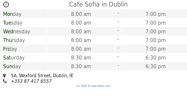
Cafe Sofia
5A Wexford Street, Dublin
Cafe
read more
1.36 km
Insomnia
312 Rathmines Road Lower, Dublin 6
Cafe
read more
📑
all categories
Accounting
Administrative area level 1
Administrative area level 2
Airport
Amusement park
Aquarium
Art gallery
Atm
Bakery
Bank
Bar
Beauty salon
Bicycle store
Book store
Bowling alley
Bus station
Cafe
Campground
Car dealer
Car rental
Car repair
Car wash
Casino
Cemetery
Church
City hall
Clothing store
Colloquial area
Convenience store
Country
Courthouse
Dentist
Department store
Doctor
Electrician
Electronics store
Embassy
Establishment
Finance
Fire station
Florist
Food
Funeral home
Furniture store
Gas station
General contractor
Grocery or supermarket
Gym
Hair care
Hardware store
Health
Hindu Temple
Home goods store
Hospital
Insurance agency
Jewelry store
Laundry
Lawyer
Library
Light rail station
Liquor store
Local government office
Locality
Locksmith
Lodging
Meal delivery
Meal takeaway
Mosque
Movie rental
Movie theater
Moving company
Museum
Natural feature
Neighborhood
Night club
Painter
Park
Parking
Pet store
Pharmacy
Physiotherapist
Place of worship
Plumber
Point of interest
Police
Political
Post office
Premise
Real estate agency
Restaurant
Roofing contractor
Route
Rv park, camping
School
Shoe store
Shopping mall
Spa
Stadium
Storage
Store
Sublocality
Subpremise
Supermarket
Synagogue
Taxi stand
Train station
Transit station
Travel agency
University
Veterinary care
Zoo
sublocality level 1
↑