Cafe nearby The Coffee Cup
Ireland
Cafe nearby The Coffee Cup
The Coffee Cup
Keenoge Irlandia
contacts phone
:
+353
Latitude:
53.6587997
, Longitude:
-6.2637752
read more
nearest Cafe
2.216 km
Sonairte
R150, Ninch, Laytown
Cafe
read more
2.808 km
Nans Cafe
3 Strand Road, Corballis, Laytown
Cafe
read more
2.811 km
Nans Cafe & Cakery
Coast Road, Laytown
Cafe
read more
4.448 km
Anagenic Hair Design
4f The Anchorage, Bettystown
Cafe
read more
4.545 km
Red Rose Cafe
Coast Road, Betaghstown
Cafe
read more
4.627 km
Bistro Bt
9 Seaview, Bettystown
Cafe
read more
5.643 km
Relish Cafe & Foodhall
Unit 4, South Gate Shopping Centre, Colp Cross, Droichead Átha
Cafe
read more
5.658 km
Mint Greene
Grange Rath, Drogheda
Cafe
read more
7.634 km
The Central Lounge
Bridge Street, Balbriggan
Cafe
read more
8.155 km
BB's
Scotch Hall Shopping Centre, Drogheda
Cafe
read more
8.156 km
O'Briens Cafe/Bagel Factory
Scotch Hall Shopping Centre, Marsh Road, Lagavooren, Drogheda
Cafe
read more
8.196 km
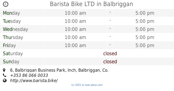
Barista Bike LTD
Balbriggan Business Park, 6, Inch, Balbriggan
Cafe
read more
8.418 km
Genoa Café
40 Shop Street, Drogheda
Cafe
read more
8.478 km
Copper Kettle
1 Peter Street, Drogheda
Cafe
read more
8.506 km
Esquires Coffee House
13 West Street, Drogheda
Cafe
read more
8.544 km
Starbucks
2 Peter Street, Drogheda
Cafe
read more
8.564 km
Cafe Lemonade
Matthews Lane South, Drogheda
Cafe
read more
8.581 km
Sage & Stone
Newlanes House, The Farm, Duleek
Cafe
read more
8.723 km
Jaffa Group
25B Magdalene Street, Drogheda
Cafe
read more
8.735 km
Drogheda Soup Kitchen
Dolan's Corner, Sunday's Gate, Drogheda
Cafe
read more
9.087 km
Costa Coffee
Drogheda Retail Park, Donore Rd, Drogheda
Cafe
read more
10.425 km
Paws Ardgillan
Ardgillan Demesne
Cafe
read more
10.893 km
Ardgillan Castle and Demesne
Balbriggan
Cafe
read more
11.019 km
Subway
Courtlough
Cafe
read more
13.168 km
Red Mountain Open Farm
Corballis
Cafe
read more
📑
all categories
Accounting
Administrative area level 1
Administrative area level 2
Airport
Amusement park
Aquarium
Art gallery
Atm
Bakery
Bank
Bar
Beauty salon
Bicycle store
Book store
Bowling alley
Bus station
Cafe
Campground
Car dealer
Car rental
Car repair
Car wash
Casino
Cemetery
Church
City hall
Clothing store
Colloquial area
Convenience store
Country
Courthouse
Dentist
Department store
Doctor
Electrician
Electronics store
Embassy
Establishment
Finance
Fire station
Florist
Food
Funeral home
Furniture store
Gas station
General contractor
Grocery or supermarket
Gym
Hair care
Hardware store
Health
Hindu Temple
Home goods store
Hospital
Insurance agency
Jewelry store
Laundry
Lawyer
Library
Light rail station
Liquor store
Local government office
Locality
Locksmith
Lodging
Meal delivery
Meal takeaway
Mosque
Movie rental
Movie theater
Moving company
Museum
Natural feature
Neighborhood
Night club
Painter
Park
Parking
Pet store
Pharmacy
Physiotherapist
Place of worship
Plumber
Point of interest
Police
Political
Post office
Premise
Real estate agency
Restaurant
Roofing contractor
Route
Rv park, camping
School
Shoe store
Shopping mall
Spa
Stadium
Storage
Store
Sublocality
Subpremise
Supermarket
Synagogue
Taxi stand
Train station
Transit station
Travel agency
University
Veterinary care
Zoo
sublocality level 1
↑